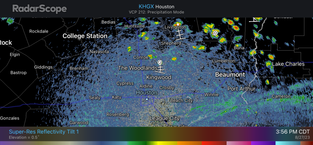
Good afternoon. As expected, it’s an absolute burner out there today. Houston’s official weather station at Bush Intercontinental Airport has already reached 108 degrees as of 4 pm CT, which is 1 degree short of the city’s all-time heat record of 109 degrees. (We matched that record high on Thursday, you may recall). It’s now a race between temperatures and approaching rain showers.
In Friday’s forecast we mentioned the possibility of some late afternoon showers and thunderstorms developing on Sunday, associated with a weak boundary. We are now starting to see those showers forming north of the Houston metro area, and they should gradually move southward into the region throughout the evening hours. Areas where precipitation falls will see drops in temperature associated with rain-cooled air.

To set expectations, these showers will be very hit or miss. Lucky locations will pick up a few, quick tenths of an inch of rain, whereas other observers will look longingly as the dark clouds and see little, if any precipitation. At this point it looks like the stronger storms are more likely to develop north of Interstate 10, but areas all the way down to the coast at least have a puncher’s chance of seeing some shower activity.
We are entering a brief period where rain will be possible, essentially this evening through Tuesday morning, before a weak front brings some drier air and shuts the door on rain chances for awhile. We’ll have the full story on the forecast ahead in our post on Monday morning, but just wanted to jump in on a Sunday afternoon with a heads up about the rain chances this evening. Good luck out there!


Ty Eric. It’s scary hot out there.
🌬❄❄❄ to all
I don’t know Eric, those showers to the north of Harris County look mighty feeble, though there are some stronger ones to the northwest and northeast. Perhaps the gap will fill in. Also, I see it reached 109 at 3:55PM at Bush airport; perhaps we will make it to 110.
Any rain is great rain. I am going to bale hay from my front yard soon it is so dry.
Although now my little weather radar predictor says it will die off before it gets to us….dang it.
Common sense and experience says it will die out before it gets here.
Please…. I am a true believer in native American lore if there are any tribal members reading this please do a rain dance or a ritual and pray for rain I know I’m not native American but I am praying for rain desperately!
I’m part Eastern Cherokee and did do a rain invocation one year and half of SW HTX flooded. Not doing that again
Ann I love your heritage! I swear not five minutes after I posted we got a shower in cut n shoot!!! Yay! LOL…. Remember the nursery rhyme, rain rain go away come again another day all the children want to play. There’s a reason why they sing it that way if not you’re right they probably would be a massive drought!
Ann, maybe if you did half an invocation?
Just a thought….
Do you remember Summer 2021?? I remember Storm o Clock, the daily thunderstorms that would push into Houston every afternoon. It didn’t go above 100 once not even August. I remember many days in the 80s and low 90s, lots of cloudy skies, and even days with stratiform rain. That summer felt like a paradise. It also gave me a false impression of what summer really is like here.
Not seeing much action on radar this seems optimistic post! Hoping I’m wrong I can’t imagine it raining here in the next week or longer…
Hi 👋🏻 – radar not loading on SCW App
😊
Uninstall/Reinstall and it’s fixed
“So you are telling me there’s a chance”- Lloyd Christmas from Dumb and Dumber
Technically 2% is a chance, I guess 😣
Oooh boy!!!! At the east side seeing some POUNDING storms!!!! It looks like a hurricane out here!!! The storm was forecasted to weaken quickly onced it reached the metro but it maintained its intensity. Hope you win many drops too!
Let’s not overlook the bright side of this drought; no mosquitoes!! I can’t remember a Houston summer without constant attacks every time I was in my yard….so there is that….
Am I the only one who finds it incredibly annoying when Houston weather people say “north of I-10” but really mean College Station, Huntsville or Lufkin? I live in the Heights which is actually in Houston north of I-10 unlike Bryan and Lufkin which is two hours away. They constantly talk about rain “north of I-10” which is where this rain happened and was nowhere near Houston. Is Lufkin part of Space City? Nope. Houston wx people should use different phrasing for where rain will really be because “north of I-10” can’t be a 150 mile range. It’s extremely frustrating to constantly hear there’s rain “north of I-10” when they really mean B/CS or Lufkin! That is NOT Houston nor the Houston metro area.
You certainly sound like someone that lives in the Heights.
Sounds like someone with knowledge of geography who is annoyed by the pervasive lack of same in local media. It bugs me too and I’m a long way from the Heights.
Hey guys! I hope everyone is doing well today. I have a couple questions, I read on the NHC website that the “Front” that came through was possibly going to stall right over our area. First, is this a possibility & if so, should we be concerned that a storm could form and come this way?
Oh and thanks in advance for yall’s help!
Thursday last week, and then yesterday, we had enough rain to create drop splotches on the car.
lower high temps are pleasant, but we need rain more.