Maybe. The very worst of it is, at least.
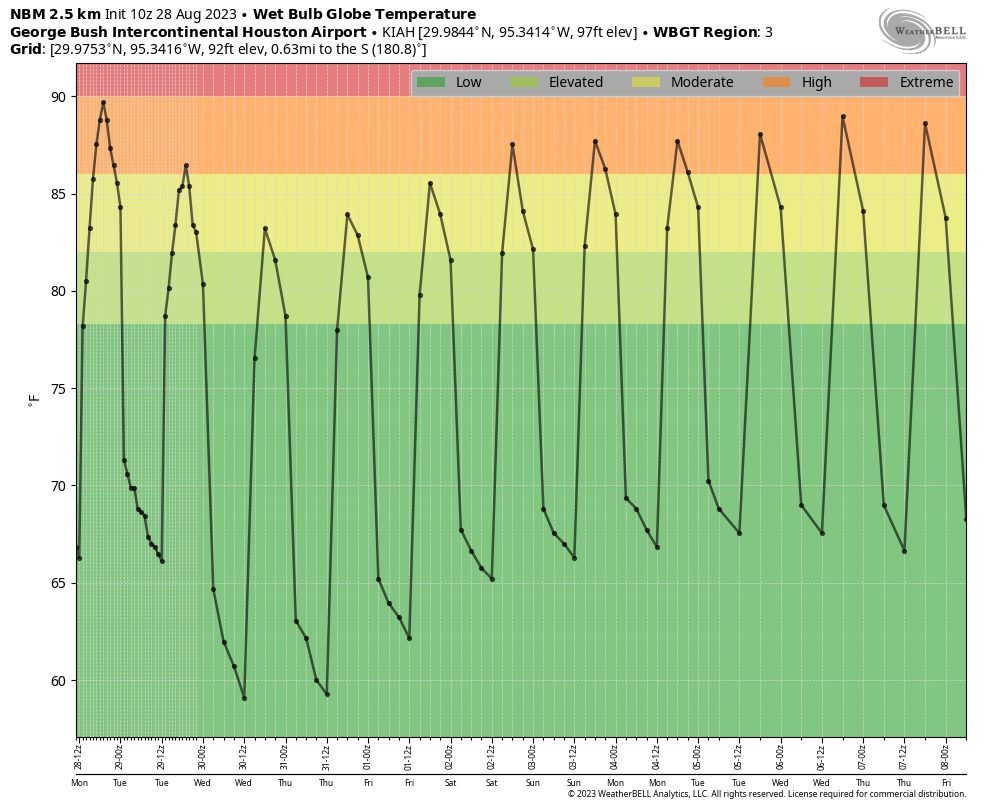
But first, let’s recap the story of this summer so far. From mid-June onward, Houston has recorded some of the very hottest temperatures on record, with July ranking as the city second warmest July (behind only July 2022), and this August on pace to be the hottest August in 150 years of records. For example this month, on Thursday and again on Sunday, Houston matched its hottest temperature of all time, 109 degrees. It has been non-stop brutal.
I am not going to sit here and predict that we’re done with 100-degree days. But I do feel reasonably confident that we’re done with the absolutely scorching days of 105-degree plus temperatures that we’ve experienced of late. Houston will now return to a somewhat more “normal” summer in terms of temperatures. Still quite hot, but probably not extremely hot.
Monday
A very weak front has moved down into the region and more or less stalled along the coast, and it should eventually bring some drier air behind it. Skies today will be partly sunny for much of the region, with high temperatures in the upper 90s to 100 degrees. There will be a decent chance of showers later today for areas along and south of Interstate 10, perhaps 40 percent, but don’t expect accumulations over more than a tenth of an inch of rain, or two. Chances further inland are probably less than 20 percent.
Tuesday
As the front pushes all the way off the coast, this should help to limit high temperatures in the upper 90s. Skies will be mostly sunny with light northerly winds. There is perhaps a 10 percent chance of rain for coastal areas, and virtually no chance further inland. Lows on Tuesday night will drop into the 70s in Houston, with some readings in the upper 60s possible for far inland areas. This is a small promise of what’s to come (hopefully) in a few weeks with the season’s first real front.
Wednesday
This should be the driest day, in terms of low humidity. Still, with clear skies and drier air, we can expect high temperatures near 100 degrees for much of the area. The good news is that evening temperatures will cool off more quickly with the drier air.
Thursday and Friday
We’ll start to see humidity levels coming back up some, but these days still shouldn’t be oppressively humid. Look for highs in the upper 90s to 100 degrees, with sunny skies and no chance of rainfall.
Saturday and Sunday
The weekend looks hot and mostly sunny, with high temperatures in the upper 90s to 100 degrees. Some rain chances will return to the forecast as air moisture levels rise, and we could see the sea breeze spark some activity. For now, call it a 20 percent chance of rainfall each day.
Next week
Next week should bring more of the same weather, with highs most likely in the upper 90s (cannot rule out some 100 degree days) and rain chances on the order of 20 to 30 percent as the sea breeze kicks up. The bottom line, I think, is that extreme summer is going away for a while, to be replaced by a-bit-hotter-than-normal summer. I think that’s OK after what we’ve been through?
Tropics
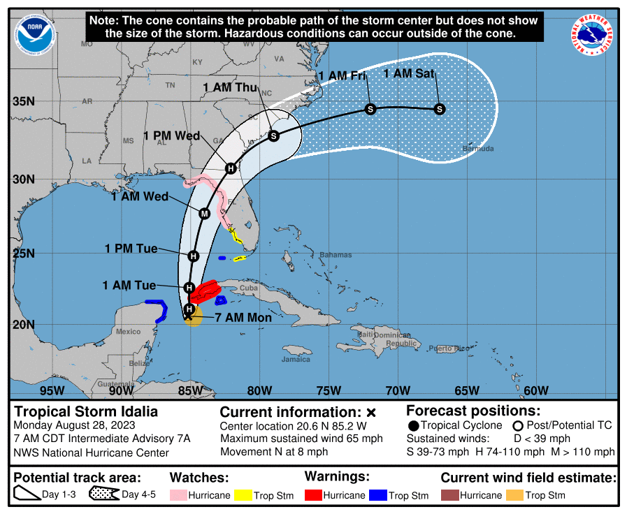
The Atlantic tropics are sizzling right now with a major hurricane in Franklin, and Tropical Storm Idalia. The latter is the bigger concern, as Idalia will menace Florida as potentially a major hurricane later this week. We’ll have full coverage, as usual, on The Eyewall website.


The radar looked so promising last night! We only ended up getting a few drops, a light show, and some serious winds.
Hopefully we get some more rain soon, before we enter stage 3 water conservation for the Houston water supply.
Nuttin’ here last night, folks.
But just as expected, the heat ridge diminishes just in time for the peak of hurricane season.
We can’t win here.
We got a nice monsoon up in Conroe last night, the entire north sky looked dark and then we had 10-20 minutes of near sideways rain followed by lighter stuff for hours (I went to bed before it ended). Ground is still wet!
Braggart!
The rain forcefield was activated again last night with seemingly every storm disappearing upon reaching the beltway.
Also, it’s sad to admit, but high 90s with moderate humidity sounds amazing. Just seeing the weather app without a triple-digit high felt like a relief.
According to my rain guage, Harpers preserve received 1.5 inches of rain late yesterday.
😉 Well in Alden Bridge in The Woodlands around 7 pm last night, their was an alien liquid descending from the sky. Thought I also saw some quickly moving, bright flashing lights above. As soon as it hit the concrete, it boiled. Our trees were bending over to drink it before it completely boiled off. 🙂
“But I do feel reasonably confident that we’re done with the absolutely scorching days of 105-degree plus temperatures that we’ve experienced of late. Houston will now return to a somewhat more “normal” summer in terms of temperatures. Still quite hot, but probably not extremely hot.”
I’ll take it. It’s something at least…no rain for us last night. Again. That makes 51 days (and counting) without any rainfall.
The word “a while” in this sentence: “that extreme summer is going away for a while,” scares me. 🙁
Okay, so, Ghost concert at the Woodlands on Saturday. Will I die from the heat? We’ll see. Rock ‘n roll! Thanks Eric and Matt!
…words, not word. duh. Also, no rain in Montrose last night. Come on, sea breeze, I’m counting on you.
I had no idea Ghost was coming! I just got into them so I think I will check them out this weekend.
Do it!! 🖤🤘🏻
Greenway Plaza area (near Central Market) we had a nice cooling shower from about 8:15-9:15. I went out and walked in it, and it was lovely.
We had some really heavy gusts of wind in Pearland late last evening–enough to knock over a ~50 lb potted aloe plant, which hasn’t happened this summer until now. No rain though.
I’d be curious to see a comparison of average Houston household electricity usage between June and now versus last year during the same period. I’m sure it’s a common complaint, but I’ve had abnormally large electric bills. I have too many new variables this year to do a comparison of my own usage, unfortunately.
My back fence in Clear Lake got crushed by a massive tree branch sometime last night. Got no rain but plenty of wind I guess.
It rained for a few hours last night north of Conroe. It was glorious! I’m less depressed with all this miserable sun and heat. I think I can make it to “fall” now.
It is going to take more than a front to produce any meaningful rain. The ground is too dry to support it. Sorry to say we need a low pressure system to move in. Does not need to be a TS. The only thing a front will do is dry us out even more.
Even deep SE Texas and Louisiana recorded110°F+ temps! Namely, Beaumont/Port Arthur (Jack Brooks), Orange, as well as Alexandria and Lafayette in Louisiana.
The “nothing to see here it’s always hot in Texas in summer” people have been pretty quiet lately…
Right? The hottest August in 150 years! No, it’s not your normal Summer…
The fast moving cool front was so welcoming.No rain but it was a moment of refreshing cool air pushing the hot air back.Thank you SCW crew for at least being honest with your weather updates.I know like science it’s not excate,but again thank you.
Not sure if this is true but apparently it hit 112 at the Bay City airport yesterday. It didn’t get near that hot anywhere else along the coast. It was 107 at the angelton airport so I am questioning the accuracy of that reading. I wonder if there may be something wrong with the Stevenson screen that is allowing solar heating to cause a false reading at the Bay City airport temperature gauge.
I think there are inaccuracies there. Same with La Porte’s apparent 113F, given how industrialized the area is with manufacturing, refineries, etc.
Seems like several of the SCW comments gallery will be at the ghost concert. See you there! Heavy metal….hope it doesn’t rain. Hahaha
nemA! See ya there!
Interesting that this post says that Sunday had a high of 109. I’ve seen elsewhere that the maximum on Sunday was 106 from one source, and 108 from another. Different temperature stations?
Has there ever been a dome of nice weather over Houston with mild temperatures an no humidity for about two months? Doubt it.
Nope lol. Now we have had October and November be mostly nice low humid weather before but there still were some nasty days in between. The fall of 1999 brought one of the biggest stretches of clear sunny low humid days in this area. Unfortunately that led to severe drought conditions. There is always a drawback somewhere.
If you recall, we had a very nice stretch of spring weather earlier this year. It was just about ideal weather around Houston, with mild temperatures and an optimal amount of rainfall from March all the way until early June. One of the nicest Springs weather-wise that I can remember. Anyone else remember back that far?
Then around June 10, the furnace kicked on, and it hasn’t shut off since.
Still no rain in Cypress. I think I actually cried last night.
Ana, had you been a Greek Goddess your tears could have soaked all of us. That’s what they usually do in Greek mythology.