Good morning. Today marks the autumnal equinox, when the sun shines directly over the equator. Put another way, for the northern hemisphere today is the first day of fall. Alas, it will not feel like fall outside, but rather the dead of summer. In fact, Houston faces five more very hot, August-like days before the first real cool front of the season arrives on Monday, ushering in drier and at least moderately cooler air.
For the last few years we have dubbed the first day it really feels like fall in Houston as FALL DAY. This year that will probably be Tuesday or Wednesday. Along with our partner Reliant Energy, we thought it would be fun to celebrate Fall Day and host our first-ever in-person event with me, Matt, Maria, Lee, and Dwight. Please join us on Sunday, October 2 between 10 a.m. and noon at the Houston Botanic Garden for a fall festive meet-and-greet with activities for kids and adults. Admission is free. Look for more details soon.
Thursday
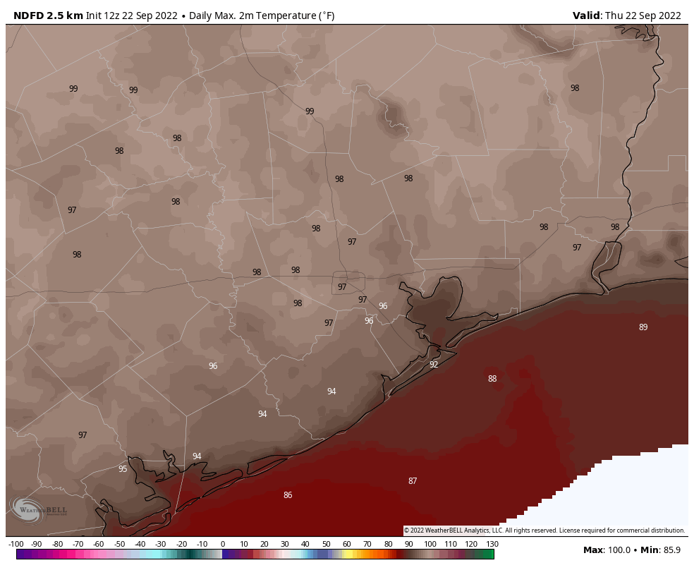
High pressure will peak over the region today, and accordingly we’re going to see very warm temperatures with highs generally in the upper 90s. A few locations well inland may hit 100 degrees, whereas the coast will reach the low 90s. Skies will be sunny, with rain chances right at zero percent. Winds will be light, generally out of the north, at 5 to 10 mph. Lows tonight will drop into the mid-70s.
Friday
This will be another hot and sunny day, with highs perhaps 1 or 2 degrees lower than Thursday.
Saturday and Sunday
The weekend will see continued hot and sunny conditions, but as the high pressure ridge starts to back off we can expect to see highs dropping into the mid-90s for most of Houston. There is perhaps a slight chance of showers by Sunday afternoon, but I would not bet on it.
Next week
Monday will be hot again, but after then we’re anticipating the arrival of a cold front that will bring drier and cooler air into the region. Days are still going to be plenty warm, with ample sunshine and dry air helping to keep daytime highs in the upper 80s to perhaps 90 degrees. But nights should cool off fairly quickly as the sun goes down, and lows drop into the 60s. With dewpoints in the 40s and 50s for several days it will feel noticeably different. Rain chances stay low.
The tropics
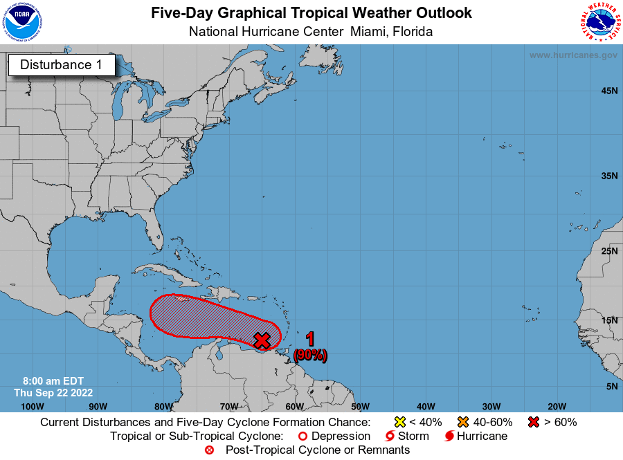
There is a lot going on, including a significant storm headed to Canada in the form of Hurricane Fiona, but for the continental United States all eyes are on a tropical wave known as Invest 98L. The system has yet to show significant organization as it is being affected by strong wind shear, but there is high confidence that this will become a tropical storm, and then probably a hurricane, over the next several days as it moves into the central and the western Caribbean Sea.
After that time there remains some uncertainty on the track forecast as 98L likely turns to the northwest into the Gulf of Mexico. Over the last 24 hours the premiere US forecast model, the Global Forecast System, has brought 98L closer and closer to Texas before it makes landfall in Louisiana about 10 days from now. See below for the latest GFS forecast, which is far enough out that it is probably worthless. I am sharing it for illustration purposes, however.
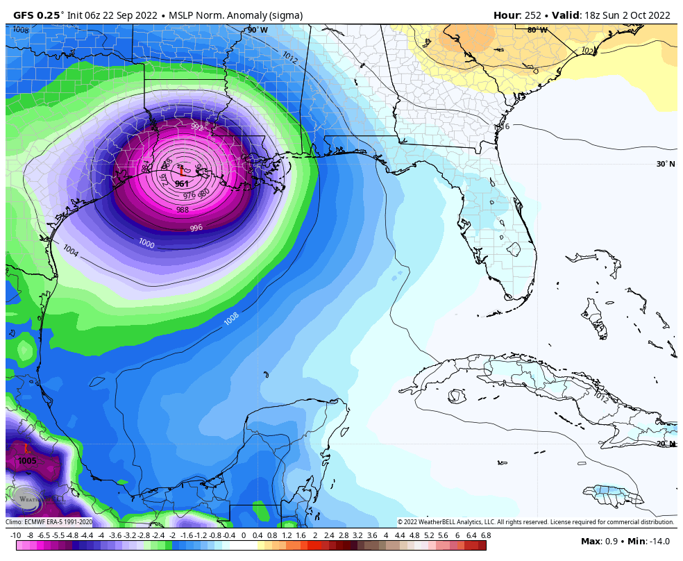
Under this scenario Invest 98L misses a “trough” that would allow it to move north early next week, and it continues to drift into the central and western Gulf of Mexico before ultimately turning north. In this case we would be watching the system for a long time. While this is certainly possible, at this time I do not consider this a likely outcome.
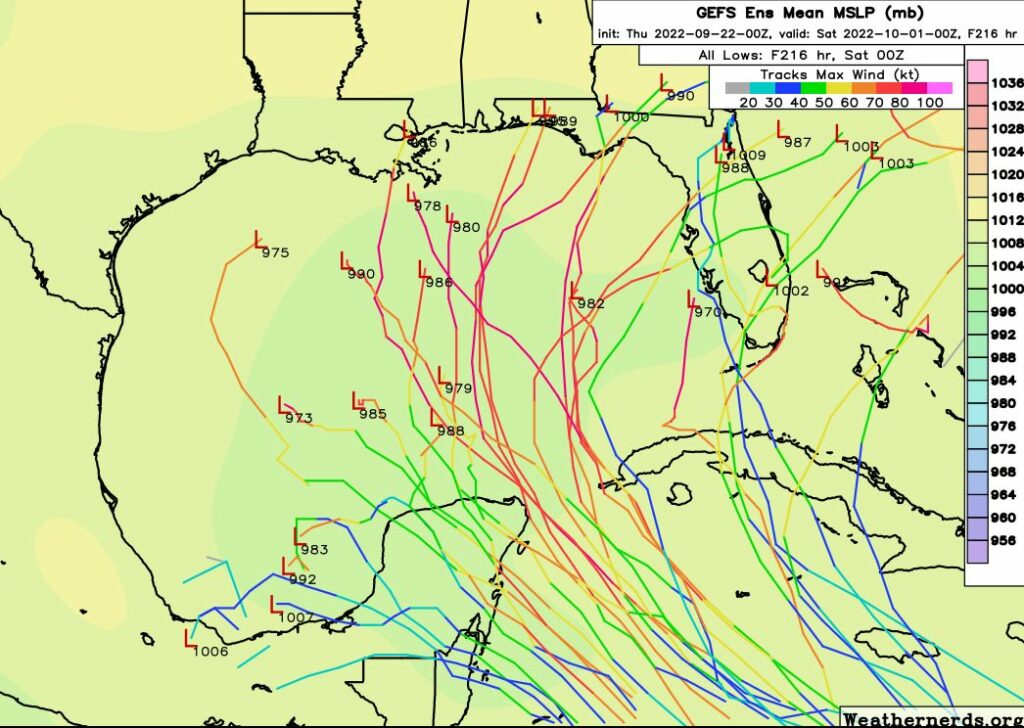
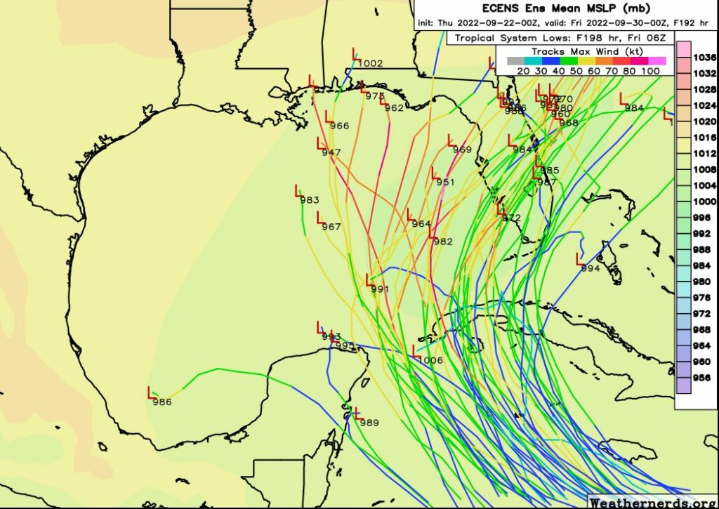
Why? Because the reality is that the GFS model’s operational run is a significant outlier at this point. The vast majority of model guidance, including many members of the GFS ensembles (shown above) and the European model (shown below), keep 98L in the eastern half of the Gulf of Mexico.
Our confidence in a track forecast should improve during the next 24 to 48 hours as the global models ingest data gathered by hurricane hunters, and the center of Invest 98L starts to form. Until that time expect a fair amount of uncertainty, and we’ll accordingly continue to watch it closely.


Astrologically the equinox is on the 23rd
https://www.archaeoastronomy.com/
Awaiting the first “should I cancel my flight” post……
And the specific timeframe question: “My flight arrives in Houston at 10:00 PM. Will my drive home be affected between the hours of 10:35 and 11:15?”
100% chance of darkness, with higher chances of intermittent light, particularly near the urban center.
My flight arrives in Orlando in 12 hours and will be there through early October. While the forecast won’t change my plans, it would be nice to know whether I need to focus on having someone prepare my house in Houston or thinking about prepping for a storm in Orlando. I am aware there’s nothing solid yet so we’ll just continue to monitor SCW from the house of mouse
The real question is “Should Katy Evacuate?” LOL
Yes, Mike. At perzactly 10:58:37.
Exactly! The “please think for me” posts are cued up!
Ha – I am flying out of IAH on October 2nd, so I have to admit I had the ‘I hope this doesnt mess with my flight’ thoughts. Nothing to do but wait and see.
When a ‘cold front’ means 90 degrees, I know it’s time for us to pack up.
The GFS has been having a horrible year, let’s hope that continues!
what about Katy?
Katy is DOOMED, should have evacuated 5 days ago.
Katy folks: EVACUATE.
People who have followed Eric since he started tracking weather are divided into two camps on the Katy reference: they hate it and wish it would go away, or they hope it never dies. I happen to be in the latter group.
Thank you, Eric.
Hi guys. Not receiving notifications when the daily post is dropped in the morning. I running most current iOS update, my settings have not changed. Please fix. Thanks, and love these posts y’all churn out daily. Keep up the good work!
I’ve been getting my app notifications every day. The issue is on your end.
Are you on iOS 16.0.1 or 16.0? Because I am and I haven’t received a single notification from SCW since I updated.
Doug, I’m updated to 16.0.01. No notifications after iOS update to 16.0. My settings have not changed, as I checked them. It seems whenever there’s an iOS update, it’s incompatible with whatever version SCW is running at that time…until SCW runs an update. Just thought I’d let the guys know. You and I have the same issue it seems.
Nope, Ash. It is not.
Are you in Katy? I’d get out now.
Several outlets have been saying “Climatological effects favor storms staying East of TX at this point in the season”. What are these effects and are they at play for this system?
Seems like for the last couple days the models have been trending west.
To be honest, I am really starting to get worried about the GFS (and the GEFS) western shift, despite the Euro holding on to their east Gulf/Florida prediction. And in this post the 00z GEFs is used instead of the newer 06z more western shift.
I think Texas and definitely Louisiana could be more likely possibilities than what people are saying.
“See below for the latest GFS forecast, which is far enough out that it is probably worthless…The vast majority of model guidance, including many members of the GFS ensembles…and the European model (shown below), keep 98L in the eastern half of the Gulf of Mexico.”
This is why the public needs to take one forecast model with HUGE grain of salt. It is also why Space City Weather and Dr. Levi Cowan (Tropical Tidbits) provide such a great service.
The moment I heard of the tropical wave in the Caribbean I thought about Space City Weather (SCW) daily updates. I feel confident at this time that SE Texas may be spared the worst of this storm but it bears watching. Like so many others I depend on SCW for weather updates so please keep the updates coming.
Eric and Matt, you use graphics from Weathernerds.org all the time. The two models they show (ECMWF and GEFS both show this mess heading into Florida. One to the panhandle area and one to center part of the state. What say you about this? I am assuming it is just too far out to trust anything yet.
Yeppers, let’s watch that uncertainty Closely. Uhh… wait- … Is it actually Possible to Watch Uncertainty? Now That’s something I’d like to see. Far Out, man. You’re kinda like, blowing my mind; like Wow, you know?