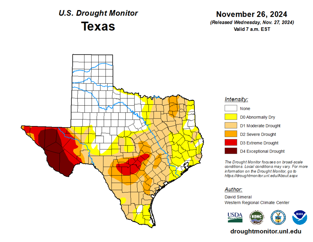
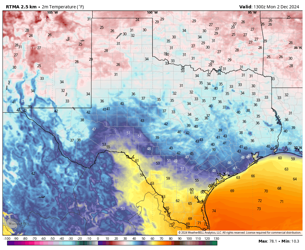
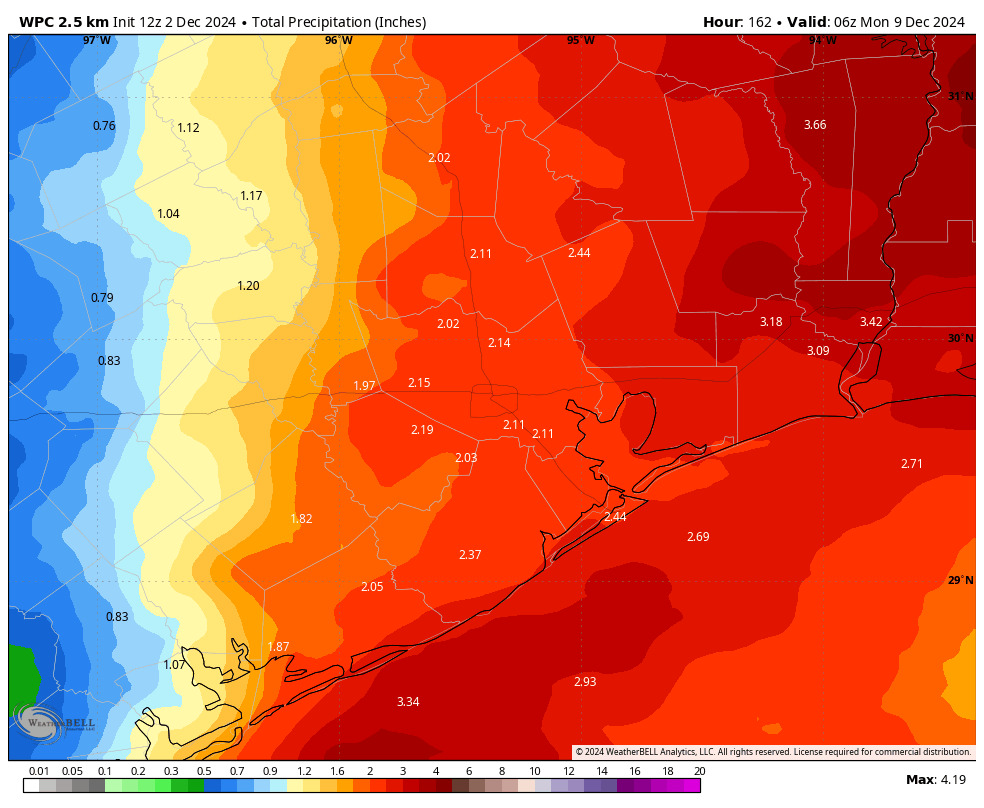
In brief: Parts of our area are continuing to see a moderate drought after a dry second half of November. Relief is coming this week in the form of light to moderate showers, although I have some concerns that the rainfall could continue into the weekend. Also, today is the very last day of our annual fundraiser!
A reemerging drought
The second half of November saw little to no rainfall for our region, and so we’ve continued to see drought conditions develop for parts of our region. As of last Friday, a majority of the Houston area fell into “abnormally dry” conditions, whereas western parts of the region including Waller, Grimes, and Brazos counties are experiencing a moderate drought. In short, we could use some rain.

The good news is that we’re going to get some rain this coming week. Although the jury remains out about how much, I expect most of the region to see at 1 to 2 inches. A couple of concerns that I’m watching are that the higher totals should be on the eastern half (rather than the western half where the rains are most needed). And there’s a chance of showers this coming weekend, when I know there are lots of holiday activities planned. We’ll be keeping a close eye on the weekend forecast for you.
Final thoughts on 2024 fundraiser
I want to tell you something: It is not easy for me to ask for financial support for Space City Weather. It is not something that is comfortable to me. However, as Space City Weather has grown, it has become a second full-time job, and there are a lot of expenses that go with running a small business. Additionally, the annual fundraiser means that we don’t have to seek out lowest-common denominator advertising, and we can offer readers a streamlined and clutter free experience. And when we release new versions of our app, there is no tracking or junk attached. It’s just the good stuff.
All of that to say: Thank you with a warm heart to everyone who has supported us so for this year. And if you’d still like to make a contribution or buy merchandise, you have a few more hours to do so right here.

Monday
Today will be sunny and cool, with high temperatures in the upper 60s. Winds will be light, generally from the northeast. We’re going to have one more chilly night, with temperatures dropping into the 40s in Houston, with possibly some upper-30s in outlying areas. Skies will be partly cloudy tonight.
Tuesday
A few clouds should keep highs a bit cooler on Tuesday, perhaps topping out in the mid-60s for most locations. This is probably our last chance for consistent sunshine until next week. As the overall flow turns southeasterly, we’ll see a warmer night on Tuesday with lows in the 50s. There will also be a slight chance of some rain after midnight, although any showers will be very light.
Wednesday
This will be a warmer and somewhat more humid day, with high temperatures in the low 70s. The combination of warmer air, more moisture in the atmosphere, and a coastal low pressure system will have drive increased rain chances on Wednesday and Wednesday night across the metro area. To be clear I don’t anticipate any real flooding issues, but of the region will likely pick up between 0.5 and 1.5 inch of rain. Lows on Wednesday night may only fall to about 60 degrees.
Thursday and Friday
There is some question about the weather toward the latter half of the week. Highs on Thursday will probably reach about 70 degrees, with mostly cloudy skies and a decent chance of mostly light rain. The question is whether a front makes it all the way to the coast on Thursday or Thursday night. I think it will, but I’m not ready to make that call for sure. If the front does make it, look for highs in the low 60s on Friday, with a modest chance of rain showers.

Saturday, Sunday, and beyond
I think conditions look mostly OK for any holiday activities on Saturday, but I’m not ready to write any forecasts for this weekend in permanent ink. Highs on Saturday will probably be somewhere in the 60s, with mostly cloudy skies and perhaps a 1-in-3 chance of rain. Sunday may be a bit warmer, with a somewhat higher chance of rain. That is all dependent on whether a front makes it Thursday, and the timing of an upper-level system that will bring some healthier rain chances into the area on Sunday or Monday.
Speaking of Monday, it could be the day that brings a stronger front through, and finally clears us out. At some point early next week the skies will clear and we should start to see some cooler nights in the 40s. But again, the forecast remains pretty fuzzy at that point.

I have to admit, I am genuinely suprised but Houston just escaped receiving its warmest November on record by the hair of its chiny chin chin. The average mean at Bush airport this November was 69.3. The warmest November on record was 1965 at 69.4. I don’t know about you but I sure could feel the difference.
Even though the 1965 November averaged very slightly above this November, The days were significantly warmer this past November. Our nights averaged cooler this Novmeber vs 1965. That is the only reason we didn’t crush that record this year. The coldest night during November of 1965 was 48 degrees.
Great info, Joseph! I always learn cool stuff from you 🎅
🌬 ❄📯❄📯❄
Good to know thank you! 👍👍❄️⛄️
We actually tied for second with 1927 at 69.3. For Galveston it was the warmest November on record at 72.2. Which is rather concerning because the urban heat island effect in Galveston is mitigated by the surrounding water.
That is because water temperatures are much warmer than normal across the entire Gulf due to the background warming of Earth. This is why nighttime temperatures have been averaging warmer and warmer across the entire Gulf states. Warmer waters evaporate more water, which creates higher amounts of water vapor. Water vapor is the most potent greenhouse gas on Earth, which prevents temperatures from cooling off as much at night. It’s not just urban areas experiencing rising temperatures. Rural areas are warming as well.
Interesting stats. I would note, however, that in November of 1965 Houston’s “official” weather station was still in downtown Houston. It wasn’t moved to IAH until 1969.
Yes that is true. This was the warmest November by far I believe for Bush airport.
I thought the Houston Weather Center moved from downtown Houston to Hobby Airport from about 1933 and stayed until 1970 and then moved to Bush Airport in 1970.
It’s saddening how we are relying on major cold snaps to not reach a top 10 record warm month, this first week of December looks stable and cool fortunately, but I’m not holding my breath just yet.
At this point of the year its cold fronts. hurricane season is over for tropical systems to help out Don’t know what else you want
Related to the drought…
After getting my 65-year-old pines through last summer’s drought, I discovered this weekend that my largest 50-foot pine is suddenly dying from a pine beetle infestation, weakened by this second round of the drought despite my watering it (albeit I am guilty of not watering it multiple times a week like I did last summer). My arborist said today that they’re seeing a new round of trees dying all over the city, so FYI for anyone who has pines in their yard, keep an eye on them. You’re looking for sudden brown outs of needles and bore holes with leaking sap, and it happens fast. Take down trees that die as soon as you’re able to prevent the beetles moving on to other pines. I’m also seeing a new round of magnolias dying, so keep watering all your trees while we’re rainless if you can.
A great reminder / recommendation, @Heather !!
We have about 40 +- pines on our Magnolia property. We’ve had to remove only one, about 2 years ago, because lightening struck it, and it eventually passed on. (We can’t run around watering all the trees, because we’re on acreage – only water those around the house and barn). We have an old Live Oak tree, huge, estimated to be 70+ years, but sadly, Beryl sliced it in half (vertically).
But you’re spot on … if you have a significant amount of pines, it’s a good idea to have an arborist come out and analyze the trees. This might be a shock to some, but we connect with the team at Texas A&M.
It is no doubt getting warmer and warming faster by degrees here. Of much more concern is the DRY. Down 41” of total rainfall from normal at HOU since 2020. Much more needs to be said of this…a weather cycle or what.
There does seem to be a cycle. If you look at the preceding 5 year period (2015-2019 inclusive), IAH recorded roughly 67″ of total rainfall ABOVE normal, with all five years experiencing above average annual precipitation.
It’s probably just bad luck of the draw with all of the upper air and surface currents being positioned at the wrong place and at the wrong time. I often fear that we are entering a similar pattern to what we experienced in the 50s. I don’t know about Houston but for every station across Matagorda and Brazoria County, 3 of the top ten driest years on record were in the 1950s.
A warming world can also cause droughts to occur more often, making them more intense and longer lasting. High-pressure systems grow stronger and sit over the same regions for longer periods of time on average, especially during the summer. The jet stream has been shifting further north and staying there longer on average than it used to, which is what keeps high-pressure ridges stuck over the same areas for so long. The hotter temperatures evaporate moisture out of the soil even quicker, which results in more rapid and intense droughts not just in Texas but globally.
Now, we have obviously always experienced intense heatwaves and terrible droughts throughout history, but they are happening more often and lasting longer than ever before in recent decades on a global scale. In our region, the worst heat waves back in the day would last a few days, maybe a few weeks, but not 3 and 4 months in a row like in 2011 and 2023. So, unfortunately, it looks like we will probably see droughts more often, along with other extremes, like heatwaves, floods, etc as we go further into the future. It may be more than just a cycle, I’m afraid.