In brief: Happy Fourth of July! We have hot and sunny weather on tap for the holiday to celebrate the birth of America, and Friday will be hot as well before rain chances increase due to the movement of Hurricane Beryl into the Gulf of Mexico this weekend. It still appears as though the system will track well to the south of Houston, with the only major impact being the potential for rain.
Thursday
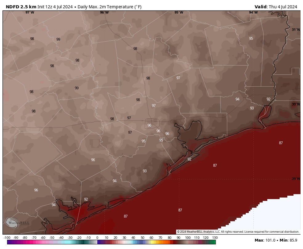
High pressure will remain in place for a couple of more days, and that means mostly sunny skies and soaring temperatures in early July. Look for highs today in the upper 90s for much of Houston, away from the coast, with generally light southerly winds. There will be about a 10 percent chance of showers this afternoon along the seabreeze. By the time of fireworks this evening, temperatures will still be in the upper 80s, at least. Lows tonight will only fall to about 80 degrees.
Friday
Another day a lot like Thursday.
Saturday and Sunday
The forecast for the weekend and next week is predicated on the outlook for Hurricane Beryl, discussed below. Our confidence is increasing in this forecast, but it is possible there are still some subtle changes. Anyway, skies should be partly sunny on Saturday, with perhaps a 50 percent chance of light to moderate rainfall. Temperatures still have a chance to hit the mid- to upper-90s for some inland locations. Sunday will see partly to mostly cloudy skies, with highs in the low- to mid-90s. There is, again, a healthy chance of light-to-moderate rainfall.
Next week
The remnants of Beryl, and tropical moisture from another disturbance, should bring mostly cloudy skies and lower temperatures for much of next week. Daytime highs probably will be in the range of the upper-80s to lower-90s. Each day will have a medium to high chance of rain, with the potential for tropical downpours. In terms of rainfall accumulations, I’m not seeing any extreme signal that will lead us to issue an alert on our Space City Weather flood scale, but that could change. Overall, I expect much of the area to pick up 2 to 4 inches of rain next week, although that remains a first-order approximation at this point.
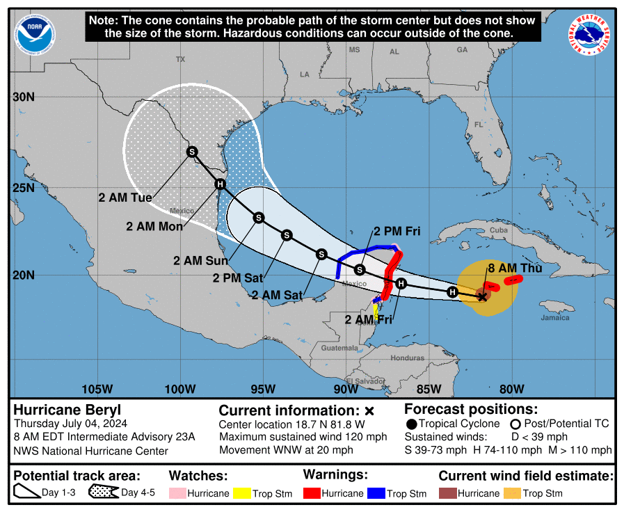
Hurricane Beryl
The hurricane is weakening in the face of moderate wind shear, with maximum sustained winds of 120 mph as of 7 am CT. It will reach the Yucatan Peninsula on Friday, and emerge into the Gulf of Mexico on Friday night, likely as a weak to moderately strong tropical storm. Beryl will then have about two days over the southern Gulf of Mexico to strengthen. Seas are plenty warm, but there will be at least a bit of wind shear. Most modeling guidance brings a strong tropical storm or Category 1 hurricane to the western Gulf coast by around Sunday night. We’ll have to see about that.
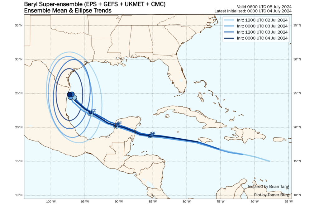
In terms of track, the most likely landfall position remains somewhere within 50 or 100 miles south of the Texas-Mexico border. However, because this landfall remains about four days into the future, uncertainty remains. It is possible the storm could track more northward, and make landfall along South Padre Island or a bit further up the Texas coast; or further south, in Mexico near Tampico. Regardless, for Houston, the primary impacts are likely to be increased rain chances. For more information on impacts to Mexico and Southern Texas, please see our latest updates at The Eyewall.
We’ll continue tracking all of this today, and if anything significant changes we’ll update the site. If not, we’ll see you on Friday morning.

Happy 4th, Space City! Thank you all for all you do to help keep us informed about the weather and much more. 🇺🇸🇺🇸🇺🇸
Happy Fourth to you, Eric! Thanks for the holiday update on this side job of yours!
Glad to hear that we’ll have increased chances for cloudy skies, rain, and a few degrees cooler next week. My wallet thanks you, too.
Alberto was just a depression that went into Mexico and it produced high tides of about 4 ft in low lying areas of Galveston; should we expect the same from Beryl?
Alberto was a tropical storm, not depression. Otherwise it would not have been named.
Thank you for taking time out if your 4th of July to share an update. Have a wonderful Independence Day. 🇺🇲 🎆 🎆
Happy Independence Day everyone at SCW. And what a perfect forecast for Sidewalk Egg Frying day! I kid you not…
https://www.smithsonianmag.com/science-nature/attempting-fry-egg-sidewalk-has-been-summer-tradition-over-100-years-180972556/
Grateful for the SCW team for calm, reasoned weather information. Thanks and Happy Fourth!
Hey! Galveston newbie over here.. super appreciate your non-dramatic straight forward coverage! This mountain girl will be the first to flee in an evac situation… keep us posted! Pretty please 🙂
So thankful for you!
Katie
Happy Fourth!Thank you for what you do!
It looks as though the current track is over the driest part of Texas. Hope they get the rainfall they need.
Please include costal areas – Galveston, Bolivar, etc – in your forecasting. Flooding is a major issue for us. Thx.
Wild guess on my part. “Space City” equals Houston, TX (only).
.
Flooding can be an issue for ANY outlying area – I know, I’ve been in the area for almost 67 years (not all in Houston area). Heck, our Cypress home got flooded by Harvey, and it’s nowhere near the coast!
.
I’d say, pay attention to the “south of i-10” comments 🙂
.
If I were somewhere along the coast (would never be), I’d be checking all weather sources, and act accordingly.
As a 66 year resident of Houston, I Just wanted to comment that so far I think this July has been pretty nice.
Warm but very tolerable. Even at age 88, I have been able to do several hours everyday of outdoor work around our house with no ill effects.
I have been especially impressed by the pleasant evenings. Low humidity and no mosquitos. Almost hard to believe I am in Houston.
Do you remember the summer of 1980?
Something like this:
…quote
June came in like a furnace that year, with the high on June 6 reaching 98 degrees — the hottest it had been since the National Weather Service began tracking data in 1889. But in comparison with what was to come, that reading was just a balmy summer’s day.
The Bayou City’s mercury hit 100 degrees that June 18, said NWS meteorologist Chuck Roeseler. Then, beginning on June 25, came a six-day string of triple-digit temperatures, all of which set records.
Houston’s June high-temperature average is 90.7 degrees. But in June ’80, said Roeseler, the high-temperature average soared to 96.3 degrees.
Things only got worse in July, with two straight weeks of record-setting 100-plus days beginning on July 6. The top July temperature — 104 degrees — was recorded at Intercontinental Airport on three days that month.
… end quote
I get being conservative and not wanting to cause panic, but the chances of this greatly affecting those in the Houston area are being undersold quite a bit.
If you’ve been a reader here long enough, you’ll understand that they’re selling it exactly in proportion to their assessment of what those chances are: in this case, low.
Undersold based on ????
I’ve got the Ventusky app and it’s been interesting comparing it to the National Hurricane Center’s projections. This afternoon they’ve shifted their track from Galveston Bay to Matagorda Bay, with a turn toward Harris County after landfall. I have total confidence in the Hurricane Center’s outlook, but having a totally different scenario to compare it with adds a note of heightened interest that would not be there if I were only seeing their outlook.
They aren’t underselling. They are selling the chances exactly as they are.
We are still too many days out to get worked up over this. The NHC forecast cone barely even reaches this far yet. Last time everyone was piling on them for “overhyping” (really, just not being perfect) with their flood alert before there was enough certainty about the risk. Anyone living here should be prepared with a hurricane stash already.
Let’s check in on the bombastic Bastardi for his take.
Predictions have been controversial for a lot of reasons (justified or not) but all I’ll say, is that regarding what happens with Beryl the next couple of days before, during and after the Yucatan, someone somewhere is going to have egg on their face. Just who or whom that will be is up in the air at the moment, much like the fate of the storm.
I have a connecting flight through houston to Brazil on wednesday. Should I cancel or reschedule?
So what are the chances Beryl could strengthen to a 4 or 5 in the gulf and alter course to directly hit Houston?