Good morning. It’s cool across the region this morning, with lows starting at about 50 degrees. But this is only the beginning of winter in Houston…
Today
The radar is clear this morning, but with virtually no wind and the moist ground, expect some low-lying clouds to persist for a few hours. After the fog burns off we’ll see mostly sunny skies today with high temperatures around 70 degrees—a bit warmer closer to the coast and cooler for inland areas. A weak cool front arrives later today, which will allow for temperatures tonight to again fall to around 50 degrees.
Wednesday
The front will keep temperatures moderate on Wednesday, with partly sunny skies and highs near 70 degrees. Rain showers should hold off until Wednesday night, when there may be a broken line of storms along with, or just ahead of a strong cold front moving through the Houston region. I’m not expecting much accumulation.
Thursday
Low temperatures on Thursday morning will be around 50 degrees, and as the front blows in they’re not going to rise during the daytime hours. As the season’s first real blue norther we’re going to see strong, gusty winds out of the north beginning early Thursday, with gusts perhaps exceeding 30 mph along the coast. The winds should continue for most of the daylight hours. Temperatures will probably fall during the afternoon hours, and lows Thursday night will be the coldest of the season.
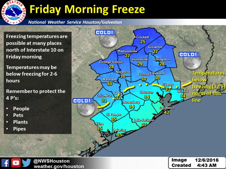
Will it freeze? I’m still betting that enough clouds linger Friday morning to keep most of the Houston metro area just above freezing. Here’s the latest forecast map from the National Weather Service as to their best guess for a freezing line.

Bear in mind this is not an exact science, so if you’re close to the freezing line and concerned about covering plants, it’s best to take precautions. (Note that, despite the graphic above, this weather will not be cold enough to threaten pipes).
Friday
Another very cold and clear day. Look for highs of around 45 (north) to 50 degrees closer to the coast under sunny skies. Lows Friday night will probably be a degree or two warmer than Thursday night—but this depends again on cloud cover. We’ll be watching for a potential freeze on Friday night too. Tis the season!
Saturday and Sunday
After another cold start, Saturday should warm into the low 60s under mostly sunny skies, and moisture will start returning from the Gulf of Mexico later in the day. This should allow temperatures to rise to about 70 degrees on Sunday. This moisture will also bring a decent chance of rain back into the forecast, so if you’re planning outdoor activities on Sunday be sure an account for the possibility of some light to moderate rain (I don’t think heavy rain is in the cards).
Next week
After temperatures warm briefly on Sunday and Monday into the lower 70s, it looks like next week will see highs mostly in the 60s and 50s. Houston appears unlikely to flirt with freezing temperatures again, but the trend toward a cooler December will continue. Winter is upon us.
Posted at 6:50am CT on Tuesday by Eric
Yay! I’m ALL FOR this forecast.
How does cloud cover impact the overnight lows?
During the overnight hours clouds act as an insulator, to some degree, of daytime warmth at the heat. Some heat, instead of being radiated into space, bounces back to the ground.
My mom (God rest her soul) moved here from up north in 2010. One night during her first winter here, I was over for dinner. We were watching the 6PM weather when the OCM said “tonight, clear and bitterly cold with a low of 30.” To which my mom shouted back, “30 degrees isn’t cold!!”.
“Cold” and “Winter weather” are relative terms. We really don’t have “winter” in Houston. Just 7 months of summer and 5 months of non-summer.
True.
This is too tempting to pass up..But should Katy Evacuate due to the cold front?
You’ll need to watch the 6 AM news. My guess is everyone will be told to evacuate to Galveston Island.