Pinch yourself, Houston. It’s July. It’s the beginning of the very hottest time of the year. And remarkably, it’s going to feel somewhat dry outside.
A bonafide front pushed through the region during the overnight hours, and into the Gulf of Mexico. Now we aren’t going to see significant cooling during the daytime with this front—the ground is just too warm, the sun is too high in the sky for too long, and there just isn’t that cool of an air mass over the southern United States during the middle of summer. But what we will see is a northerly flow and significantly drier air. You’ll begin to feel this tonight, and it will be pretty amazing for this time of year.
Tuesday
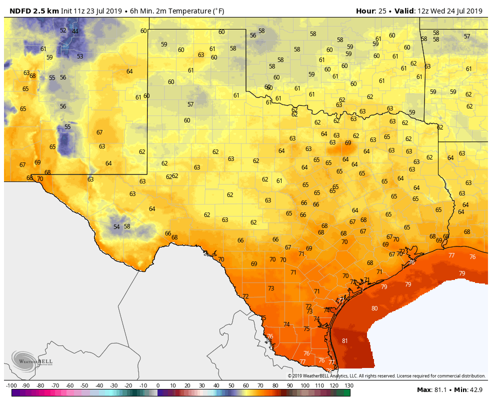
The front blew through with only scattered showers. The high-resolution models had been trending drier, and the bulk of the storm activity remained offshore. The same models are indicating we may see some brief redevelopment this morning between Interstate 10 and the coast, but after that the atmosphere should really begin to dry out. Highs today will be around 90 degrees with partly to mostly cloudy skies. Skies will clear later today or this evening, and lows should get down to around 70 for most of Houston.

Wednesday
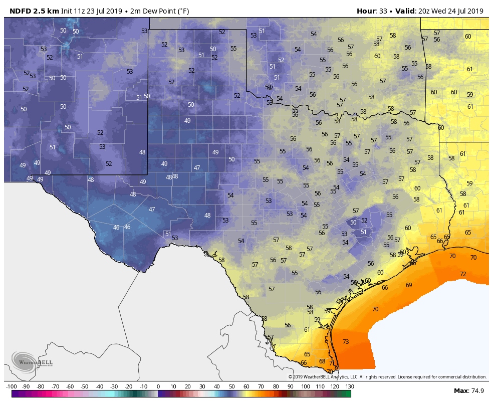
This day will be the pick of the litter. Under full sunshine, highs on Wednesday will only climb to about 90 degrees, and with dewpoints generally in the 50s, it will actually feel like 90 degrees rather than in the 100s. Wednesday night should be the “coolest” and driest of the week, with lows falling into the 60s for inland parts of the metro area, and low 70s along the coast. The record low at Bush Intercontinental Airport for July 24 is 68 degrees, and that may be within reach for the airport. We’ll see.
Thursday and Friday
Conditions will be a little bit warmer, and a little bit more humid these two days, but conditions should still be nice for the metro area. We’re talking low 90s during the day, and low- to mid-70s at night, with lots of sunshine.
Saturday and Sunday
All good things must end, especially the fleeting phenomenon of a July cool front. By later on Friday, onshore winds should kick in, and by Saturday we’ll fall back into a much more typical summertime pattern. Highs this weekend should be in the low 90s, with partly sunny skies, and plenty of humidity. Rain chances will also be on the rise, likely in the 40 to 50 percent chance for the weekend. Accumulations look decidedly modest, however, likely 0 to 0.5 inches for most. This pattern will likely persist into early next week.
Eric, your article in the Houston Chronicle on Chris Kraft was excellent.
Thanks! He was a friend and a mentor to me.
“…This pattern will likely persist into early n̶e̶x̶t̶ ̶w̶e̶e̶k̶ October.” Well, at least we had these few days. Shame it doesn’t happen more often.
Too true … sadly.
“Onshore winds,” “offshore winds.” Meteorologist lingo. It’s kind of like “tornado warning” and “tornado watch.” Yes, if you (the reader) think about it, you can figure out the difference between the two, especially in context. But why have to figure it out? Why don’t they just say “southerly” or “northerly” or “from the south” and “from the north?”
Two reasons: 1) Because the coast runs on a southwest to northeast line here, so it would never be sourtherly or northerly and 2) because the wind seldom blows due north or due south anyway, even away from the coast. Therefore, onshore and offshore are far more accurate terms.
And if you don’t understand the difference between a tornado watch and a tornado warning, you could find yourself quite dead.
The very interesting Chronicle article you co-wrote about Chris Kraft was most appreciated. It reminded me of all the science articles you used to write for the paper. I looked forward to reading them.
Thanks Judith. You can find everything I write that’s space related here:
https://arstechnica.com/author/ericberger/
Including this fond remembrance of Chris Kraft:
https://arstechnica.com/science/2019/07/christiopher-columbus-kraft-nasas-legendary-flight-director-has-died/
I’ve been receiving the Rocket Report since its inaugural launch, it’s really helpful! Same as this site, extremely helpful.
Was hoping for some rain. Time to water the lawn…
Same!
Yep. Back yard is D.E.A.D.
I need to figure out how to sell the rain that’s been falling on mine. Lawnmower stalled three times Saturday because the grass was so thick.
Do I detect a note of irony?
🙂 Wait a minute — weren’t you complaining about zero rain a few weeks ago? 🙂
Sorry, I have to ask… will this cold front keep tropical development from developing in the northern Gulf or at least keep it to the east?
No problem! And in answer to your question, we don’t anticipate development, but if there is it likely will move NE.
Thank you for updating us on the topics. I love the stories you write. Thank you for all your iinsite.
This is what I remember on July 20, 1969. I was 12 years-old and my family was at the St. Christopher’s Church bazaar located about 2.2 miles north of Hobby Airport. Before 1970, Hobby Airport was the weather center of Houston. In 1970, it moved to Bush Airport. The normal Summer highs in Houston was 92 degrees Fahrenheit and the normal Summer lows were 72 degrees F.
It seemed like almost every Summer day there was a 20% chance rain and it seemed to rain almost every Summer day from a few drops to a 15 minute gully washer. It seemed every Summer day the skies were partly cloudy during the day and clear at night. Of course, Houston had a lot more trees and vegetation and less buildings and roads.
On July 20th, In the middle of the afternoon, an isolated thunderstorm must have developed over the area. A brief gully washer followed and a lightening strike knocked out power in the area. When the rain let up, my family left the bazaar.
We arrived home without any power and we were worried we would miss Neil Armstrong stepping on the Moon. Fortunately, the power was restored around 9:30 P.M. and we would be able to see the first steps on the Moon. My Mom and I stepped outside about 10:30 P.M. it was mostly cloudy, but there were breaks in the clouds to see the Moon briefly. I must be mistaken, but I thought the Moon was almost directly overhead at that time.