I don’t want anyone to get the wrong idea. In the big picture, the remainder of August looks very hot. There is just no way to sugarcoat that. However, there are some subtleties in the forecast to keep things interesting, including modestly low humidity today, and a tropical wave in the Gulf of Mexico next week. We’ll discuss all of that below.
Wednesday
A weak front has pushed very nearly all the way to the coast this morning. As we’ve been discussing, this is not an October cool front, so at most we’re seeing some dry air. But as Augusts go, it’s rather nice outside this morning. Much of the area is seeing temperatures in the 70s, with dewpoints in the 50s. This kind of weather isn’t coming back any time soon, so I’d recommend stepping outside to avail yourself of it.
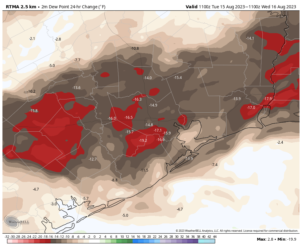
This modestly drier air, alas, will also heat up rather quickly. So even though we’re experiencing a front, most of the area will still reach the upper 90s to lower 100s today. Still, I invite you to walk around and say, “At least it’s a dry heat,” to your friends because we simply don’t get to do that too often in Houston. As for the lower humidity, it will largely be gone by this evening for the southern half of the metro area, and overnight for everyone. So get outside this morning.
Thursday and Friday
I’m afraid we’re going right back to high humidity, daytime highs in the low 100s, sunny skies, and rain chances of about 5 percent or less. So basically, like the weather of August to date.
Saturday and Sunday
The weekend should bring more of the same, with hot weather and mostly sunny skies. If I squint, there might be some 10 to 20 percent rain chances on the horizon for Sunday.
Next week
Well, it’s complicated. We’re still anticipating a tropical wave to develop in the central Gulf of Mexico early next week, and then move westward. Since writing about this, several readers have expressed concern about this wave developing into a hurricane, but there are a lot of reasons why that is unlikely to happen, among them a fairly high forward speed. The National Hurricane Center suggests there is about a 20 percent chance the system becomes a tropical depression over the next seven days, and that feels about right to me. So while we’ll keep track of winds and waves, that should not really concern us much.
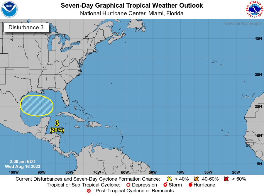
No, this is one of those August systems that is going to bring some beneficial rain to somewhere. The real question is whether that somewhere is Southern Texas and Northern Mexico, the Central Texas coast, or the Upper Texas coast and Louisiana. Now you may be thinking Eric, what do I have to do to make you bring that wave to the Houston area? First of all, I can’t be bribed—except maybe by ice cream. But secondly, the answer lies in the evolution of a potent high pressure system over the Midwestern United States.
The map below shows a rather intense high developing over Iowa, Missouri, Nebraska and Kansas next week. If the high is too strong, it will force the Gulf system south of Houston and Louisiana. If the high is further south than that, then again, it will force the wave south of the Greater Houston area. So we need that high to be a bit weaker, and a bit further north, to really enjoy the benefits of some widespread rainfall on Monday, Tuesday, and Wednesday of next week.
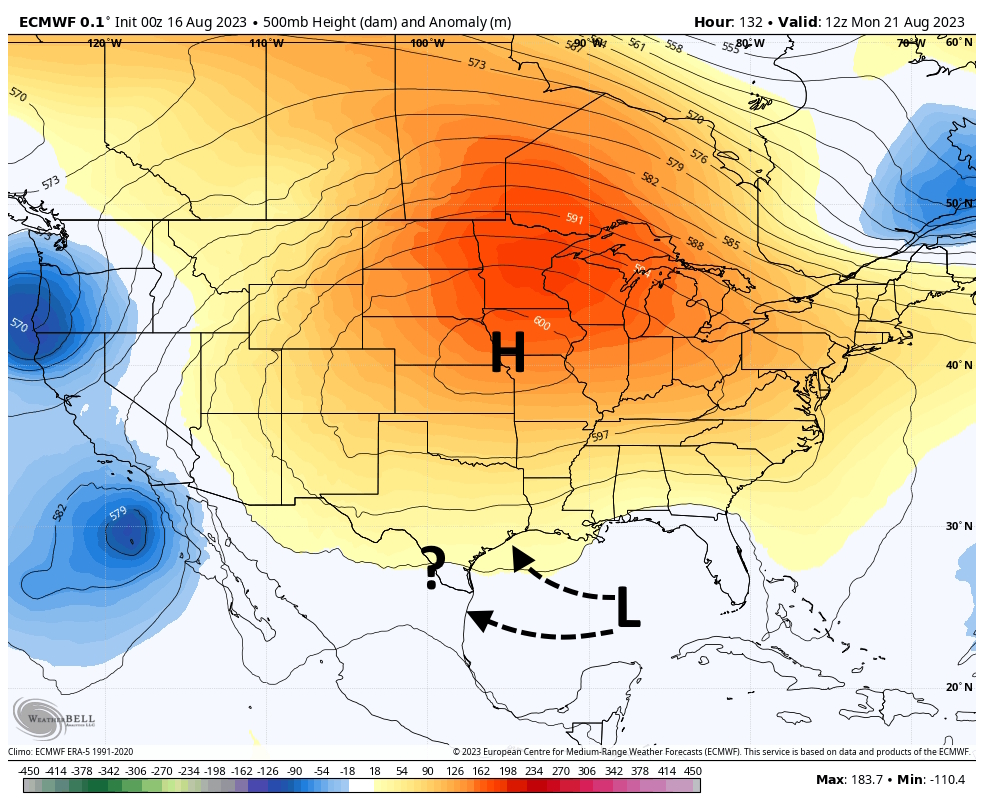
Things could really go either way at this point. From an emotional standpoint, I’m pessimistic that we’re going to get the rain relief we desperately need. It’s been a long, hot, brutal summer, so why should things change now? From a data-based standpoint, there’s a reasonable chance of rain for our region next week. Hopefully the forecast clarifies itself in the next day or two.


WOW! What a shock this morning! This temporary dry air REALLY felt good! Can enjoy morning cup of coffee on the deck! YEEHAW!!
Absolutely! Walking out without a drop of sweat? In August??? But a dream (that came true)!
Also pessimistic, the 58% rain chances at Hobby went down to 39%, and the high for that day went from 94° to 96-98°.
Only got down to 82 this morning, but at least the dew point dropped 13 degrees in an hour. Was able to take a walk at 5:30 this morning for the first time in two weeks.
Now, an August cool front came through and the tail of it is in the Gulf during an abnormally quiet hurricane season. Hmm… that’s how Alicia went from nothing to a Cat 3 in about 2-3 days…
🍦 sounds really good – and a strawberry milkshake 🍓
Most recent GFS and Euro model runs have the ridge holding firm over the central US through next week. We’re cursed.
Models will change throughout the days ahead Martin
6 pints of Jeni’s Splendid ice cream if you can coax that rain to the greater Houston area. My moral perseverance is inversely proportional to the heat index.
I will take it, porch coffee is great right now hopefully we can graduate to beer on the porch in the afternoon. I guy can only hope
We ain’t gettin nothin this month except less humidity for half a freakin day.
Where do I send the ice cream?
Feels wonderful this morning! Played with my kiddo before the bus picked her up and now I’m sitting on the porch with my baby. If only this would last…
Appreciate the detailed honesty and clarity about next week.
I accept your invitation and exclaim, “at least it’s a dry heat today!”
What a pleasure to walk the dog this morning and not be wringing wet by the time we returned home!
It dropped down to 75 in Sweeny this morning with a dewpoint of 63. It felt like heaven. The high was 98 with a dewpoint of 61, which only put the heat index at 99. It was still very hot in the sun, but it was noticeably more comfortable than yesterday. It was horrible yesterday with a high of 105 with a heat index of 115. Bay City airport reached 107 yesterday which broke the all time hottest August temperature ever recorded in Bay City. I reckon this was due to the compressional heating that occurs just ahead of a cold front, but still this is getting ridiculous. I have observed many dead trees in my area recently. I haven’t seen this since 2011, which is insane because the drought this year isn’t near the level it was in 2011 at this time. It must be the relentless heat plus the accumulation of all the weather extremes we’ve had the past few years.
As someone with reverse S.A.D. this summer is awful. I cannot stand the sun anymore and I am praying for 1 cloudy day, some thunder, ANYTHING. It is absolutely depressing.
If the tropical wave becomes a very strong named storm, will it have an exit path, or could the high pressure hold it over Houston for days?
The high will be north of the system, so the system is expected to move westward quickly.