It’s been nearly eight years since the last significant tropical system (Ike) impacted the greater Houston region. So understandably, when NOAA’s National Hurricane Center began tracking the tropical wave that became Hurricane Earl, the region became a little jumpy. Was it, after a record-breaking “hurricane drought” in the Gulf of Mexico, our turn again?
In the end, Earl came nowhere near Houston, instead making landfall as a Category 1 hurricane in Belize. Nevertheless we thought it worth discussing the factors that control the path a hurricane takes, so that the next time a system threatens the Gulf of Mexico we’ll all have a little more knowledge, and perhaps be less susceptible to any hype.
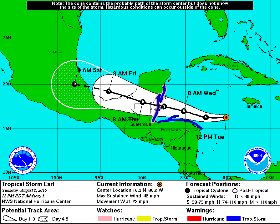
The graphic above is a version of the one we’re all familiar with—it shows the location of then Tropical Storm Earl at the time of the advisory, its projected track and intensity, the forecast cone, and any watches or warnings. Arguably, the most important information in this graphic is the track of the storm, because it (obviously) tells us where the storm is headed, and who will be potentially impacted.
What controls where a hurricane goes?
There are two main forces that control where a hurricane goes—the environment, and something called “beta drift”. The environment around a hurricane is the main force behind the direction the storm goes, “steering” it in one direction or another. The primary environmental steering for storms that form in the deep Atlantic tropics—these are the systems that move off Africa and spin into tropical lows—consists of the east-to-west moving trade winds, which drive storms across the Atlantic and toward the Caribbean and the Gulf of Mexico.
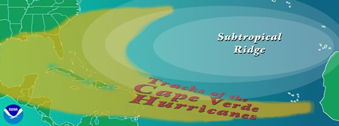
Other environmental factors will also influence storm motion, particularly areas of high pressure and atmospheric troughs that serve as “roadblocks,” preventing storms from encroaching upon the pressure areas. The diagram above shows how the subtropical high (also known here as the Bermuda High) acts to block storms. In the case of Earl last week, as it moved into the Caribbean Sea, a large area of high pressure over the continental U.S. helped prevent the storm from curving up into the U.S. Gulf Coast. It was blocked from doing so, and therefore steered into Mexico.
The other major factor in hurricane tracking is “beta drift”. When a storm begins to spin around an central area of a storm (the eye), it creates a vortex. When this happens, Coriolis force (the force that, in the Northern Hemisphere, deflects atmospheric motion to the right of its path) causes the storm to drift, generally toward the poles. This is why most hurricane paths in the Northern Hemisphere, after they find a weakness in high pressure over the mid-latitudes, begin to curve northward and to the right.
These two factors help us predict where a hurricane will go, with some accuracy. Advancement of forecasting models, computers, and techniques in the last few years have also helped. With that said this is a somewhat simplistic view. As ever with weather, there are many other factors that must be considered with storm direction—strength of trade winds, upper air flow, sea surface temperatures, interaction with land, and others—that cause storms to sometimes take unexpected paths:
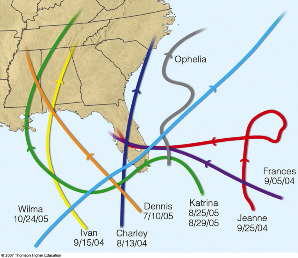
As you can see, storms can vary widely from the classic, northward curve we see most commonly. This is why, when hurricane forecasts are made, we provide the forecast cone around the expected track, in case things change. Even though we can say in somewhat certain terms if a storm will impact Houston or not, it’s always smart to be prepared!
Very informative. Remember Ike well. Also Alicia! Saving this article for future reference. Hoping not to need anytime soon. Yes all we can do is be prepared.
Although there is also the KatyKomplexKoncern — a situation where weak steering currents allow storms to follow an inclination to hit just west of Houston. Extra precaution is required in those cases ….
Very nice review. Thanks. Out of curiosity, what forces made Jeanne so unusual?
Great question! I did a bit of research, and it looks like that steering flow that usually drives the storm weakened for five days, so the storm slowed way down. Without any steering flow, it drifted north, and once the steering flow kicked back in, it looped around and took off toward Florida. Reading the NWS report on Jeanne, I saw that they made a note that “forecasts failed to capture the turn north and subsequent loop”. Something like that is very hard to predict!
This is great information, and without the “hype” we get from many (not all) TV folks. Thanks!
Thanks! Be sure to tell a friend about the site, if you don’t mind.