In brief: March has been fairly warm, and this coming week will bring us some of our hottest weather of the year so far. But that does not necessarily mean spring is over. In fact, next week looks to be quite a bit cooler with the possibility of lows in the 40s for a few mornings.
It’s still spring, right?
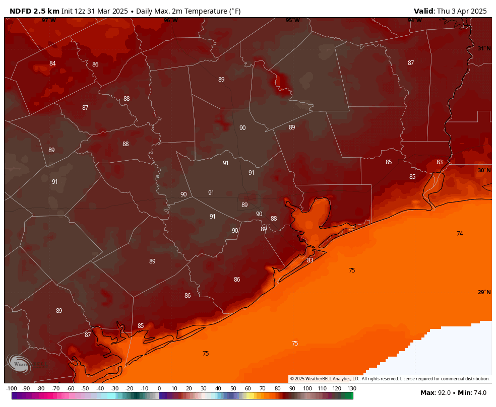
March is drawing to a close today, and by the calendar we are supposed to have two more months of spring. However, this March has been rather warm, running more than 4 degrees above normal. Moreover, this week will see several days with temperatures in the upper 80s to 90 degrees. It might almost feel like summer is at hand. However, we have fairly high confidence in the arrival of a robust front this coming weekend, which will bring temperatures back into line for spring.
Monday
It is rather sticky outside this morning, with temperatures in the low- to mid-70s and dewpoints nearly as high. A very weak front is on our doorstep, and it will slowly sink into the region today, knocking down humidity slightly. Look for high temperatures in the low- to mid-80s with mostly sunny skies. Temperatures tonight will drop into the mid-60s for most of the metro area.
Tuesday
Some fog will be possible Tuesday morning, and as it lifts we should see mostly cloudy skies. This should help limit highs in the lower 80s. The front won’t last long, as we’ll see winds picking up from the east, and then the south later on Tuesday. They may get fairly gusty, up to 25 mph. Lows on Tuesday night will drop only into the lower 70s for most locations.
Wednesday, Thursday, Friday
These should be fairly similar, fairly warm days. Each day should bring partly sunny skies, and warm temperatures. Highs will vary from the upper 80s to about 90 degrees for most locations. We’ll also see gusty afternoons, perhaps peaking at 30 mph for a few hours. Nights will be quite warm, dropping only to about 75 degrees.
Saturday and Sunday
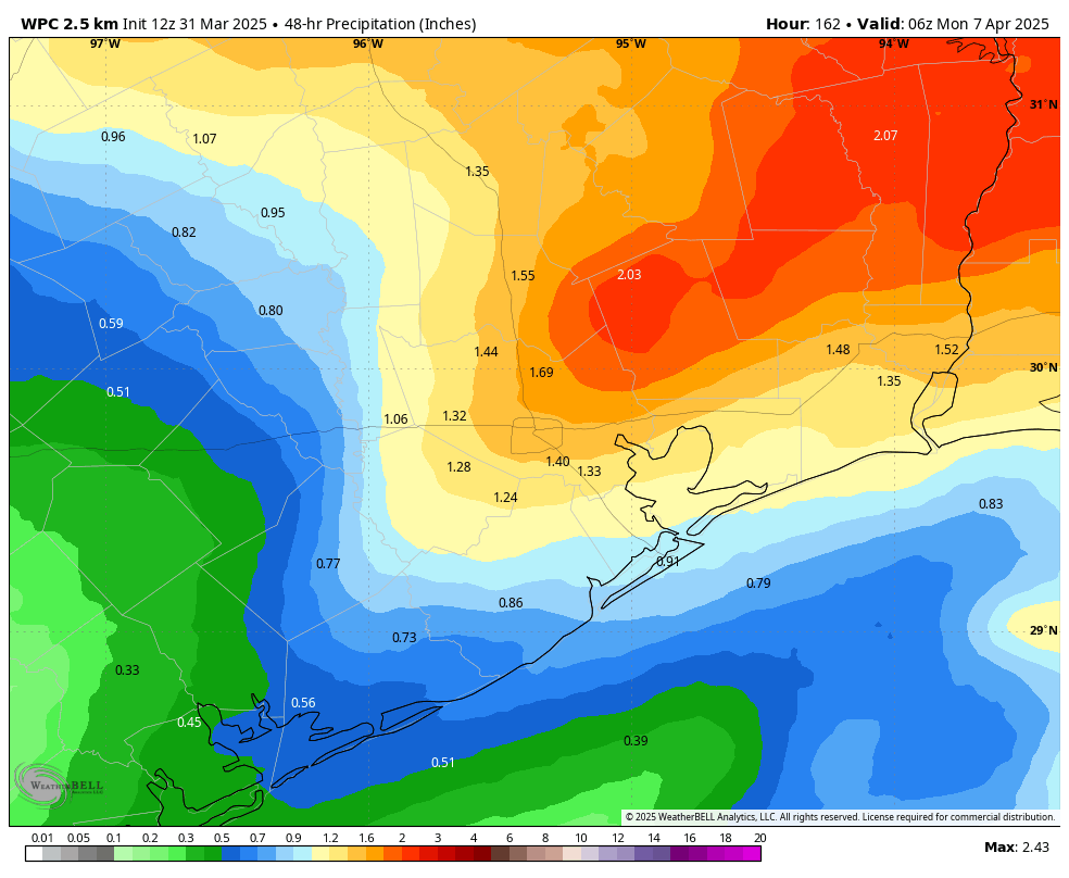
The weather for this coming weekend is somewhat unsettled. Saturday looks to be mostly cloudy, with highs in the mid-80s, as an upper-level low pressure system brings elevated chances of rain into the region. At some point on Saturday or Saturday night, most likely, a stronger front will push through the region. Lows on Saturday night may drop down to around 60 degrees, depending on the timing of the front, and some showers may well linger into Sunday morning. Highs on Sunday should top out in the vicinity of 70 degrees, or so. If you have outdoor plans for Saturday and Sunday, showers and thunderstorms are a concern, but not a certainty. We’ll fine tune things as the weekend gets closer.
Next week
Houston will face a nice slug of cooler weather next week. Although it’s impossible to be too precise this far out, I’m thinking days with highs of around 70 degrees and lows in the 40s or 50s. So yeah, it will be nice to have a chill in the air again for a few days. The cooler weather should hang around for most of the week.

disgusting temps during this time of the year. smh
And I just can’t wait for a July and August full of 10 degrees above normal…you know it’s coming.
This is our climate now
Hockey Stick…………..
I sure am glad we’re not further east – those poor folks will have nothing but back to back storms for the next several months.
Some spring weather will be nice, maybe the last chance to wear a light jacket or sweater for a while.
We’ll see how we fare with the weekend’s weather for the 70.3-mile Ironman in Galveston! Hopefully the rain can hold off for a good amount of that day!
Eric/Matt — thank you for the Sunday update on potential storms. Can y’all address the NOAA limitations/how that impacts forecasting potentially strong storms that don’t materialize (as happened yesterday), or not forecasting ones that do? Thank you.
Noticing a trend. “October has been fairly warm” “November has been fairly warm” “December has been fairly warm” “January has been fairly warm” etc
Eric has a subscription to ensembles. I swear there was no storm this weekend on early last week’s freebie GFS or ECMWF. Very interesting to see that. He called this weekend 7 days ago! I don’t think it’s data gaps – You have to pay for weather if you want the inside scoop – which is fine. The irony comment on Houston balloon launchings yesterday (there have never been any) and the gallery comments was very funny! Good radar tech is the answer for protection. The trouble with the “cap” is if it breaks – wowser 😅
Hopefully you don’t feel different regarding paying for premium services vs free come hurricane season
Like I’ve said before…no one, no one, except the Canadian product ICON, had Beryl coming here. I am absolutely positive we will have plenty of hurricane coverage for free. It drives ads after all.
I remember Matt/Eric saying that ICON was not a top tier model and has frequent inaccuracies. And a random hit doesn’t vouch for it.
And ICON is German, not Canadian, run by DWD. If you’re going to tout something, do it right.
No one said anything about Houston radiosonde balloons yesterday.
NWS is a public service for the greater good, and it’s not ‘fine’ to monetize people’s safety by withholding vital info for money.
You need a better hobby.
J and W: Why are people so nasty on here? I am simply saying that not every missed forecast is the result of a cut. Also people are already paying for extra weather info that free service doesn’t provide. Just make it better, not less.
It’s pretty sad that Eric is having to assure us that spring will return because summer has arrived in early April 🙄
The March strat warm is finally going to bring us some chilly air.
I seem to be the only one happy about these mid 80 days. It’s not unbearably hot, but warm enough to swim. Am I looking forward to summer and the pool feeling like bath water? No. But me and the kids were getting bored of the cold weather. Its only fun if there’s snow lol.