In brief: In today’s post we look at our warm-ish start to April, and how we’re going to turbo-charge that this week before a nice front arrives this weekend. We should be back to seasonal temperatures then, but we’re still trying to read the tea leaves as to whether it will rain with the front.
Warm April nights
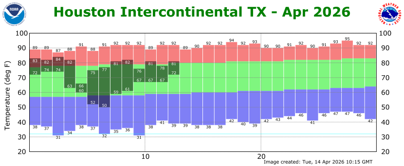
So far April is off to a pretty warm start, with an average temperature of 71.4 degrees, a little more than three degrees above normal. But where we have really felt this is with our nights, which are typically in the upper 50s through the first half of April. However, we’ve been mostly in the 60s and 70s. We’re not close to setting any monthly records (through the first two weeks, our average and average minimum temperatures are not in the top 10 warmest of all time). But we are going to take the warmer-than-usual temperatures we’ve seen during the first half of April and super-charge them this week before a front returns us to seasonal conditions this weekend.
Tuesday and Wednesday
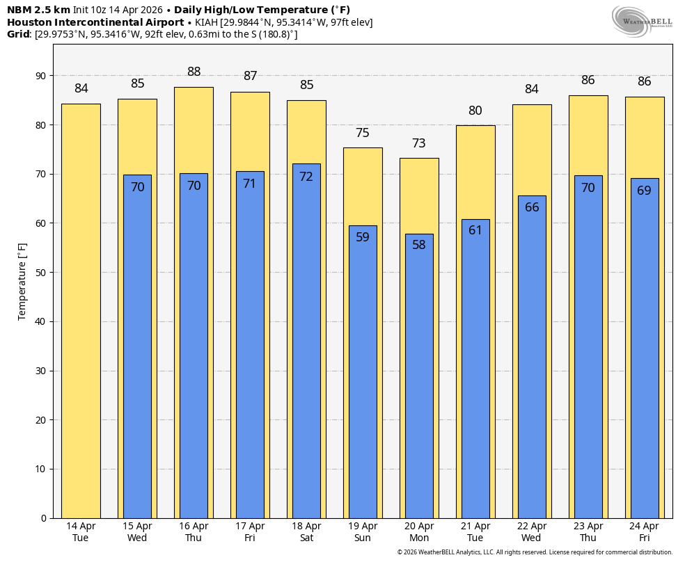
These days will both be similar, with a strong southerly flow (winds gusting up to 25 mph during the afternoon) bringing warm air and temperatures into the region. Expect highs in the mid-80s with partly sunny skies and plenty of humidity. Overnight lows will drop to around 70 degrees in Houston, with slightly cooler conditions for outlying areas. Although there is plenty of moisture in the atmosphere, a capping inversion will likely suppress any shower activity.
Thursday and Friday
I expect both of these days to see a little more sunshine, and accordingly I suspect our daily temperatures will push into the upper 80s (although probably not all the way to 90 degrees). Overnight lows remain warm and muggy, and those gusty southerly winds will continue. Rain chances, still, remain near zero with the possible exception of areas along and north of Highway 105.
Saturday and Sunday
The weekend will bring some cooler and drier air in the form of a front. But when? Right now I’m thinking Saturday evening is the most likely time. Assuming that’s the case—and to be clear, we are not locked in yet—Saturday should be another warm and fairly humid day with highs in the 80s. I do expect more clouds and a slight chance of light rain during the morning and early afternoon. At some point during the afternoon or evening a line of showers and possibly thunderstorms should drop down from the northwest along with the front. At this point I’m not seeing any signal for severe storms or heavy rainfall (a dry frontal passage is also still possible). This front should push Sunday morning’s lows down to around 60 degrees. Highs on Sunday look to be in the 70s, with lower humidity and partly (to mostly?) cloudy skies.
Next week
I think we’ll see overnight lows, possibly in the 50s, persist through Tuesday morning before we warm up again some, probably back to around highs in the lower to mid-80s by mid-week. Rain chances appear low before next weekend.
