Labor Day may have come and gone, but that doesn’t mean we’re going to see an immediate end of summer-like weather. As long-time Houston residents know, the first half of September can often feel almost as warm as August. That’s why, when we get to this point we’re often pretty desperate for the first real cold front of the season, and this year is no different.
Probably the most simple way to define the first “real” cold front is when temperatures fall to 65 degrees, or lower, on or after Sept. 1. This generally weeds out rain-cooled days and anything that isn’t a genuine front. When we do this for Houston, the following pattern emerges for the first fall cold front, with an average date of Sept. 18.
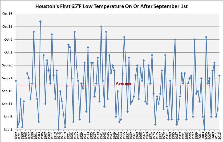
It’s worth noting that, sometimes, the first front does not arrive until early- to mid-October. Let us hope that is not the case this year.
Tuesday through Friday
As noted earlier, we’re going to fall into a summer-lite pattern this week with a mix of moderately high pressures and high atmospheric moisture levels. Essentially what this means is daytime highs in the low 90s, overnight lows in the mid- to upper-70s, and a 20 to 30 percent chance of showers, mainly during the afternoon hours.
Saturday and Sunday
Conditions look more or less the same for the weekend right now, but that could change. I’d expect partly to mostly sunny skies with highs in the low 90s. To some extent our weather could be dependent on Hurricane Newton, which is over the Baja Peninsula, and remnants of which will move into Arizona and New Mexico later this week. But my guess is that we’ll remain more or less in this summer lite pattern.
Next week
Forecast models have gone back and forth with the chances of the first “real” fall cold front arriving next week, sometime between the 12th and 15th. This would be a few days early, but about the time we might genuinely hope for that first front.
About 30 of the European model’s 50 ensemble members show a moderate to significant front coming through. So that equates to perhaps a 60 percent chance of getting a nice front through during the first half of next week. I am so ready.
What are you guys thinking about 92L’s chances of development?
Very disorganized, and most likely will stay that way. We’re watching.
Better watch some more, Eric. 00Z CMC sends 92L to Texas as a Tropical Storm in 240 hours!
Lol, OK.
I’m so thankful to God for this change. So humid. I live in New ORLEANS, Louisiana. The leaves on my trees have been changing colors and falling to the ground. Which indicates change. I love fall weather. It is a joyful feeling of peace. Everyone seems to be enjoying the coming for Thanksgiving. Football , coolness , crispy feeling in the air . Sweaters, fireplaces and homemade soup. The warm feeling of others. The beginning of Autumn falling into fall. Love it. I was born November 15, 1953. The best time of all Seasons. LULA JEAN WETWISKI.
Is there any truth to the rumor that when the fall cool fronts make it to Houston, the hurricanes don’t? Have any tropical systems hit Houston after we’ve hit that 65 degree mark?
That’s partly true. When we get a couple of cold fronts through that basically closes off Texas from hurricane activity, but it’s far from an iron clad rule.
Do you think that Invest 92 is going to impact our weather?
Very disorganized, and most likely will stay that way. We’re watching.
Is there any potential threat from 92L?
Doesn’t look like it at this time.
Good news – and sorry, hadn’t seen the other questions when I posted.
Love the data, thanks!
A histogram would also be informative, so we can get a better visual sense of the cumulative probability of when that cold front will blow through. Eyeballing the time series plot, it looks like a 90% chance of a break by Oct. 1, based solely on the historical data.
Also, is it just me, or does there appear to be some strong negative serial correlation?
Maybe, it’s hard to tell from this plot alone.
Any chance the last 17-18 months are the wettest ever in Houston? 115 inches in 17 months seems like a good candidate to me…
That is a good question. I will check.
Two questions, please: why the heck do we continue to get so much rain? It’s been a 3 week cycle with evidently more coming. And what do you predict our fall/winter will look like?
1. I think we’ve just seen a few very wet seasons back to back. I can’t think of a single explanation for why we’ve continued to see such periodic, heavy rains.
2. According to NOAA, fall should be warmer than normal, with near-normal rain. Winter will be warmer than normal, with drier than normal conditions. (But I have little faith in seasonal forecasts, to be honest.)
That graph reminds me of the first front of 2011, which came early considering how dang hot that summer was. Probably the most welcome cold front in modern Texas history. Of course, we were back into the 100s the week after, but feeling that stretch of 60s in the morning was amazing.
I agree. That summer is still burned into my memory.
I was beginning to think I was the only one pacing back and forth wanting 92L to DO SOMETHING, preferably get lost…Hermine toyed with me longer than I like…
Is the raw data (dates) behind the front chart avvailable ?
I would like to update for 2014 forward.