One question I’ve noticed from several folks in recent days has been some variant on “is it safe to tend to the garden yet?”
@mattlanza Can I start planning my veggie garden now? No real chance to freeze again, right? #NeedAnotherProjectLikeAHoleInMyHead
— Terri Schlather (@AGirlintheSouth) February 4, 2018
While we’ll probably avoid any sort of serious cold over the next 7-10 days, the advice I’ve been giving people is to give it at least another week or two. There’s a lot of uncertainty in the weather forecast going into mid and late February, and I’m just not convinced we’re completely out of the woods here in the area. Frosts can cause issues; it doesn’t take 20 degree weather to be problematic. On average, Houston’s last sub-32 degree morning is around February 15th. We’ve done as late as April 10, 1973, and, more recently, as late as March 21, 1996. Yes, it can get cold well into March here. As much as we’d love to say yes, go ahead and get busy, it’s probably prudent to just sit tight a little longer if you can. This winter’s surprised us more than once. We’ll keep you posted.
On to the forecast.
Today through Wednesday
After a mild Sunday, we’ll start the week just a bit cooler behind yesterday’s cold front. Look for upper 50s under clouds or lower 60s with more frequent sunshine today. We’ll have more clouds than sun in general, and a few sprinkles or pockets of drizzle could develop this afternoon, especially south/east of US-59. Onshore flow will continue to ramp up tonight. That should mean more clouds, showers, sprinkles, and also some fog around heading into Tuesday morning.
On Tuesday, we’ll have a warm air mass in place, along with increasing Gulf moisture. This should set the stage for scattered showers and perhaps some thunderstorms across the area. I don’t think everyone will see thunderstorms, but there is a chance for some stronger, hail-producing ones, primarily north of I-10 later Tuesday into Tuesday evening.
Expect temperatures on Tuesday to warm from around 60° in the morning to around 70° later. Tuesday night should see the best chance of storms shift a little further north of our area. A cold front will finally approach the area on Wednesday, cutting northwest to southeast Wednesday morning. We’ll start Wednesday probably in the mid 60s, but by midday or so, temperatures will likely drop back into and through the 50s. Plan to dress for two seasons on Wednesday. With the front, expect another round of showers and a chance of thunderstorms in the morning, and a continued chance of showers or some storms through the afternoon.

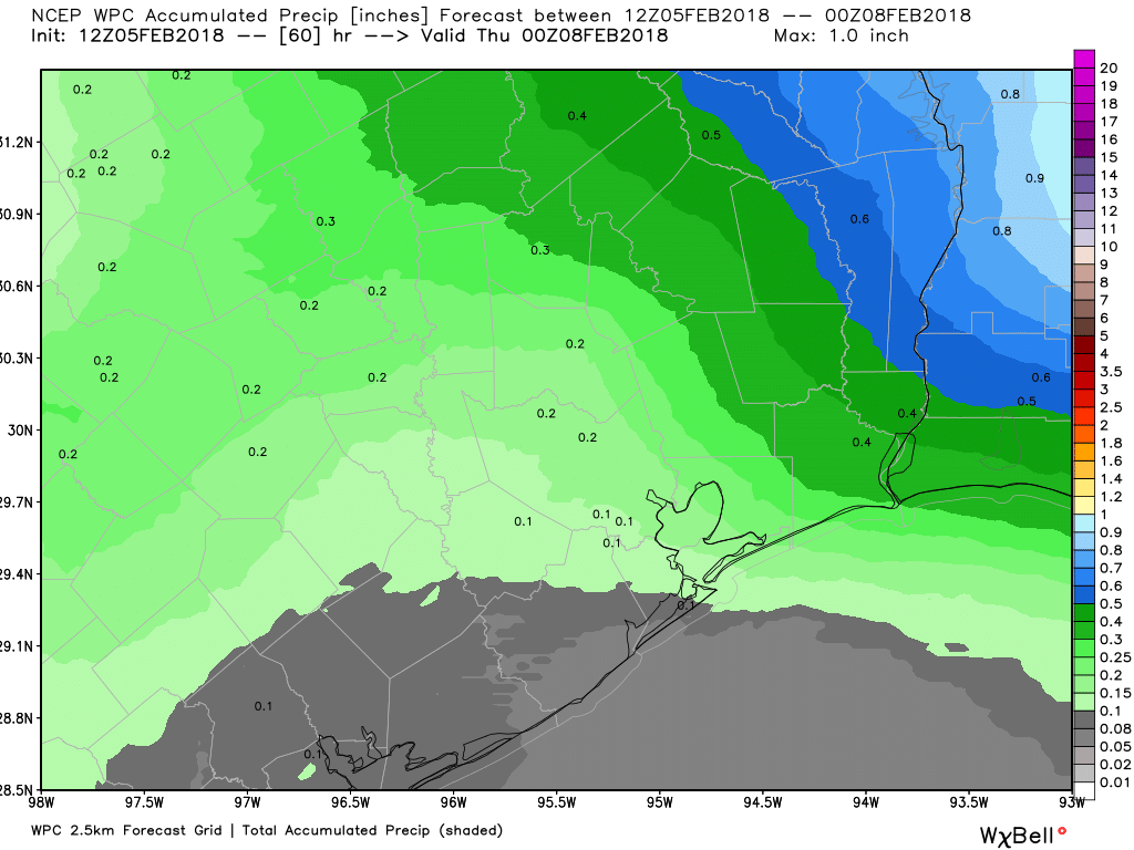
On average, expect a quarter to half inch of rainfall through Wednesday evening. Some areas may see a little more if showers and storms are persistent. As noted on the map above, some areas south of Houston could even see a bit less.
Thursday & Friday
As of now, I expect Thursday to be a pleasant day. It will start chilly, with lower 40s in the morning, warming to the upper-50s or near 60° in the afternoon. We should see a mix of sun and some clouds and a dry day.
Starting as soon as Thursday night, onshore flow resumes. We’ll probably bottom out at some point in the 40s and then slowly rise toward Friday morning. Look for increasing clouds and humidity Friday. With that, at least a few showers, sprinkles, or some drizzle will be possible Friday afternoon with highs in the mid-60s.
Weekend
While we’re still a few days away from nailing down the details, I don’t have the best of news for the upcoming weekend. We should see scattered showers and thunderstorms, probably not all weekend, but at various times both Saturday and Sunday (with a focus on Saturday). Right now, there looks to be a healthy amount of moisture available for showers and storms, so we could also be talking about locally heavy rainfall also. It does look fairly mild though, with temperatures at least in the 60s. We’ll obviously keep you posted as we get closer.

Dear Nature,
STOP RAINING ON SATURDAYS. That’s what Sunday night and Monday are for.
Thanks,
Everyone
I’m over it. I’m ready for heat and dust.
Eric thanks for the gardening direction! And if folks are itching to get started gardening (when it’s not raining) check out a County Master Gardener website like the one for Harris County at hcmga.tamu.edu
I don’t remember who told me when I first moved to Houston, but the advice on starting garden was wait until at least the rodeo had started!
About 5 or 6 years ago we had a blue norther come down about March 5-6, low temps 20-25. If you plant now, keep your frost blankets handy. No frost blankets? Don’t plant now. Also, remember the admonition about soil temperature–lots of summer plants don’t like cold soil, and soil can be too cold regardless of what the air temp is.
This is almost as fun as the stock market!