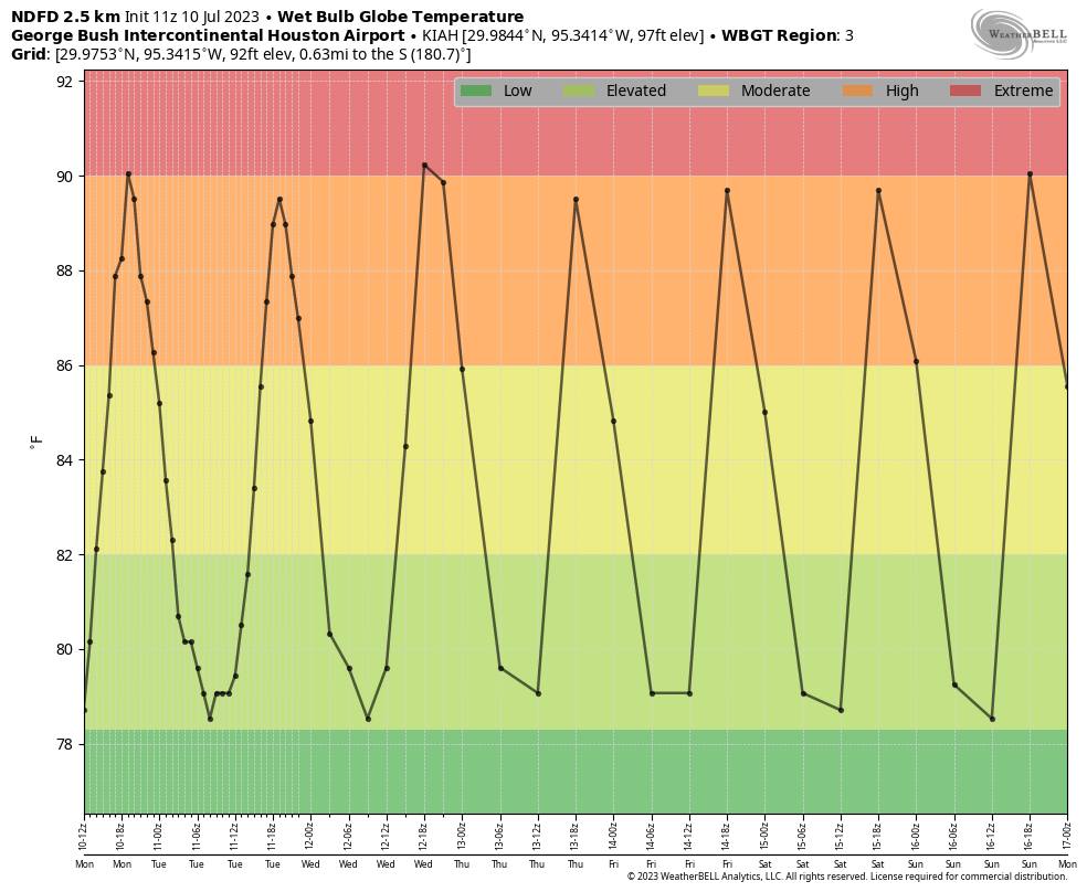
We talk about the heat index from time to time, and this characterizes the heat outside by factoring in both the temperature and relative humidity. This is also the basis for “feels like” temperatures on television broadcasts. But there is another, still more accurate measurement of heat stress if one must be out in the direct sunlight, and this is called the “Wet Bulb Globe Temperature.” It’s a bit of an odd name, but it takes a lot of factors into account, including temperature, humidity, wind speed, Sun angle and cloud cover. Chances are, if you’ve been in the military, you heard of the Wet Bulb Globe Temperature.

The important thing to remember about these temperatures is that anything above 80 degrees requires precautions, and anything above 90 degrees is dangerous if you’re outside for a prolonged period of time. I say all of this because the Wet Bulb Globe Temperature is a good measurement to characterize the extremeness of the heat we’re going to see this week, and the bottom line is that it should not be quite as bad as what we experienced in June. Back then, daily Wet Bulb Globe Temperatures were consistently in the low 90s. This week we will be a few degrees below that. It will still be very warm, with a heat advisory in place for much of the region. But it won’t be quite as extreme.

Monday
That was a rather long introduction for what will be a short forecast as high pressure over West Texas influences our weather for this week and beyond. Expect mostly sunny skies today, with high temperatures in the upper 90s. There is perhaps a 10 to 15 percent chance of isolated showers and thunderstorms this afternoon. Light southwest winds of 5 to 10 mph will provide little relief. Low temperatures tonight will only drop to around 80 degrees.
Tuesday
A similar day, with slight rain chances and highs in the upper 90s.
Wednesday, Thursday, and Friday
Look for highs in the upper 90s to 100 degrees, sunny skies, and warm nights. Each day will be more or less the same as we bake.

Saturday and Sunday
The temperature may increase slightly this weekend, as sunny skies prevail. Hot, hot, hot.
Next week
At this time I don’t foresee too much of a change heading into next week. There are some scenarios in which we start to see a decent chance of rain by around Tuesday or so of next week, but at this point it’s difficult for me to bet against persistent heat as high pressure reigns supreme. Rest assured, we’re looking for any signs of change.


Eric where can I go to find the current WBGT for my area?
Google Wet Bulb Calculator and input the temp and humidity and you’ll get close.
Eric…might WBC be something you continue to include weekly this time of year?
https://mesowest.utah.edu/cgi-bin/droman/meso_base_dyn.cgi?stn=KDWH&unit=0&timetype=LOCAL
Here is a link to Hooks Airport that gives classic Wet Bulb (not exactly WBGT).
Important typo. I think you mean “back in June” instead of “back in July.” for your link in your description under the guidelines chart of various temperatures and rest times.
Eric
I think you meant June instead of July in your hyperlink just above the graph.
Remember that 1980s, “This is your brain on drugs” commercial? With the egg in the frying pan? A WBGT of 95 produces an identical result.
Your explanation on heat indices helps. My home weather station gives me ambient temperature, heat index, and “feels like” temperature. It all can be a bit confusing.
Take at least 45 minutes of breaks each hour…like that’s gonna happen.
And for the love of Dog, please don’t take your dogs out for a walk in the middle of the day and talk to your dog walkers. We (animal professionals) keep talking about it, but I still see people dragging their poor dogs around at midday and in the early afternoon.
I take my dog out at 8 am and 8 pm. Otherwise we’re stuck inside…
sucks how the east is getting all the rain and we are not
Is there a way to obtain real-time WBGT info? Have been reading you for quite awhile and thanks for your and the teams’ efforts!
GWBT is a nice metric if you’re running a crew and want to be proactive on work efficiency and heat exhaustion. But it’s sooo complex. For me, just the standard wet bulb temperature used in engineering calcs for all things having to do with evaporative cooling is fit for purpose. Humans, dogs, and machines. Most of us can read T and RH at will (T should always be read in the shade away from hot pavement, your car temperature indicator is very overstated!) and Omni calcs will give you a wet bulb. Weather.us tracks wet bulb hourly and you can look back 96 hours. It peaks between 4-5P. If over 82F get into shade for sure, otherwise just keep hydrating.
Great info! 😀
Ty 🌻
Also referred to as the Dew Point of the air. Here is a calculator that I found online.
https://www.calctool.org/atmospheric-thermodynamics/wet-bulb
Today our plant issued a level 3 heat advisory even before lunch. We don’t have a level 4.
All the explanatory words will not alter the reality that it is hot, it is going to stay hot and only get hotter in the future. Wet bulbs notwithstanding, it is a misery outdoors.
Last year my temps were running 103-108 every day in June and July. This year in Washington Co, 95-98
Why no mention that it is cooler this year?
You are correct, Jos. July 10, 2022 was 105 in Houston, breaking the record of 101 set in the 90s I think. It WAS hot last year. The July 11 2022 blog is the one that set off 101 comments from the comment gallery because Eric mentioned “climate”. That number of comments was only recently exceeded a few days ago.
NOAA.gov has wet bulb forecasts and there’s a link for local ones. I look at Houston’s there a lot lately. Sorry if it’s already been mentioned -but I have to check this now to see if I’ll let kiddo go to marching band camp daily. At least it’s figured out for me. It’s helpful! -LT
Thank you for these forecasts. I read yours and barely glance at the news. You make it more tolerable . 🙂