In brief: The next 12 to 24 hours will bring the potential for severe weather into the greater Houston region. Impacts include heavy rainfall that may lead to street flooding, damaging winds, large hail, and potentially tornadoes. Please be weather aware.
So far, today, the Houston region has been spared direct impacts from severe weather. The storms have remained well north and west of our area. However, that is likely to change in the next few hours as a line of storms, now impacting the College Station areas, is advancing from the west.
These storms will likely reach the northern half of the Houston area this afternoon and early evening. They will bring all of the threats described above, and may make a mess of the Tuesday evening commute for areas along and north of Interstate 10. Not everyone will experience strong storms, but the risk is there.
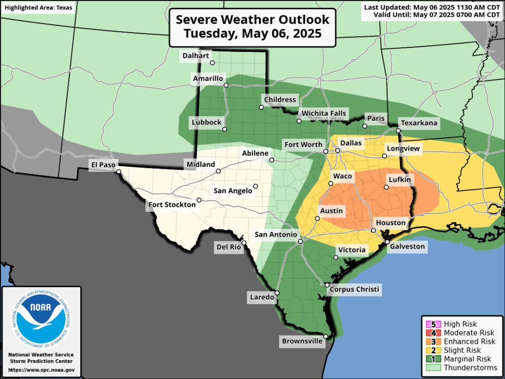
This evening, and into Wednesday morning, these storms will probably spread across the entire region, including into coastal counties. The storms will lose some of their severity tonight, with the loss of daytime heating. This will diminish the threat of tornadoes and hazards such as damaging winds and hail. But the potential for strong thunderstorms and heavy rain will persist.
By Wednesday morning the majority of action will likely have shifted to the coast, or possibly be pushed offshore. Even so, you’ll want to remain weather aware as you get up and about on Wednesday morning.
Just to repeat myself here: Not everyone is going to be bombarded by severe weather, but the atmosphere above our region appears to be primed for storms during the next 12 hours or a little longer. Please remain weather aware this afternoon, evening, and on Wednesday morning.

Fix your stage 2 flood graphic.
if you’re talking about the graphic in the article – that was issued by the National Weather Service and is a stage 2 Severe Weather threat and not a flood threat –
Why is it that the atmosphere is always “primed” in the Houston area, but storms fail to materialize?
I would like to know as well. You can literally see storms dodging around Houston and continuing on their way. When I lived in NYC this happened a lot there, too. Like an invisible force field.
Heat islands
Heat islands is what I used to think. Now I have no idea but the literally seem to go around us. Assuming something with cappinginversions?
It’s gotta be more than just the heat island effect though? When I first moved here to Houston it wouldn’t stop raining. Every couple days there was a downpour. Now it seems so infrequent, and when it does rain, it’s mostly a misting or a sputter
Concrete Jungle.
Thank you, as usual…you are calm, clear and provide guidance.
Why was the “first” round of storms a bust? A lot of busts lately
Ty Eric ⚘
As I type, I’m watching KBTX News (3.1), with Kayleigh T. (meteorologist) reporting the current weather. Seems all the earlier weather concerns are going away. Radar confirms it, as well as some Warnings have been lifted.
We anticipated some severe weather here, but not worried now. Tornado Watch will expire in 15 minutes, and the approaching “storm” should last about 10-15 minutes. Even the trees are motionless 🙂
Out here in Sealy I kept checking the weather and radar late in the afternoon as the line of storms to the west developed and multiple severe thunderstorm warnings were issued, along with reports of golf ball sized hail along I-10 near Columbus. I was anticipating conditions getting a bit hairy when I heard the thunder approaching, but after about 10 minutes of heavy, soaking rain, it just suddenly stopped, even the thunder, which honestly felt a bit weird.
Storm was a bust. Nothing here in Montgomery.
It does appear that Round 1 was a bust, at least for the general Metro Houston/Harris County area. Very similar to last time and it appeared that a cap was in place again based on the way the storms arced around. Round 2 is coming and so far doesn’t look too bad, nothing severe yet. We’ll see about Round 3.
Once again the storms are falling apart before hitting NW Harris co.
Hardly a drop of rain at the northwest loop. Do Houston weather people, including SCW, ever say “maybe we shouldn’t report there will be severe weather in Houston when we’re continually wrong?” We ended an event early because of the “storms” that, of course, never came. Yet again, a bust.
My favorite part is that they never bother to circle back and address what happened in the atmosphere that prevented the rain. A lot of us would really like to know!
you know weather prediction is not 100% accurate, they go by what data is showing on models when they post their outlooks for each day. The issue is modeling this year has not been good which people should be concerned what is causing inconsistency. I hope you don’t do the blame game on them during hurricane season
No blame game, but how about some follow through or follow up? That would be nice. Let’s take some lessons learned from an inaccurate forecast, simply for the sake of education
The models are broken. Eric and Matt simply interpret the data so it’s not their fault. What’s weird is that the models seem to consistently overestimate rain..rarely does it rain more than predicted.
Some sources are indicating that there won’t be a Round 3.
constant failure to materialize any real storms, lovely.
Is this constant model failure the past month or two caused by DOGE, or what? I wouldn’t be surprised if by the end of this whole storm system we get less than half an inch. A few days ago every global model and the WPC were predicting at least 2 inches of rain where I live. And I think where I live is actually doing better than many other parts of town. What really bugs me is that for the past month or two the global model ensembles have been forecasting above average rainfall in the Houston area a week or two out, but then when it gets near the event, the forecasted rainfall evaporates into hardly anything. We have gotten about half as much rainfall as normal over the past 2 months. And now it looks like we will be facing a summer heat dome for the next several weeks once this system moves out!
Why are there so many people whining it’s a bust? You want another derecho?
I apologize if my comments came across as whining. They were meant to be observations. I certainly don’t want another derecho, or any severe weather for that matter.
No, we simply want some decent rain before we enter the next 4 months of hot drought
I understand the value to meteorologists of using modeling in their work. I’m curious if in addition to that whether they also use other “old fashioned” tools like anemometers, barometers etc as well as going outside to see, smell and feel what is actually going on. While I view this site every day, many times can tell the forecast is not correct – at least for my area. The greater Houston metropolitan area and surrounding communities are a very large area to cover weather wise. These guys have a hard time. Let’s face it, no matter what one believes in climate change or not,
mother nature, weather, will do what it’s going to do. Long before the terms global warming and climate change were coined I’ve seen snow in Florida, drought in Seattle, heat waves above the artic circle, fog for a week in Yuma, Arizona, and I suspect these kind of anomolies, no matter the cause are what draws people like Matt and Eric to this field. Weather as nature is unpredictable no matter why or when. Whether pleasant or not it is an expression of the mystery and magic of life and this universe we all exist in. Thank you Eric, Matt and the rest of your team for pursuing your passion and doing your best to predict the unpredictable.
For those wondering, a lot of why the storms never really materialized in the metro area was due to lack of instability. A very large MCS (squall line) to the north of us shielded us from surface heating which underperformed by a bit, farther to the west there was plenty of CAPE (4000-5000 J/Kg) which is why a lot of the storms out west went severe. Lapse rates also underperformed by a bit. Although I do agree it was a forecast bust, spring time weather is very unpredictable and meteorologists such as Eric and Matt are doing their best. The problems at NWS and NOAA certainly don’t help either.
Thanks for all you do over there at SCW!
(Also feel free to correct me if you believe I’m wrong)
Thank you for this thoughtful analysis! That’s all I’ve been asking for.