At least 422* times per winter (*approximately), the question of whether “the polar vortex is coming” seems to come up. The sources are many: Rogue social mediarologists who want engagement, well-intentioned meteorologists who are just trying to explain something but the wrong takeaway gets amplified, not-well-intentioned meteorologists who can’t help themselves, and weather enthusiasts who are misinterpreting model guidance.
We are in one of those phases now, so is the polar vortex coming for us again like it (sort of) did in January?
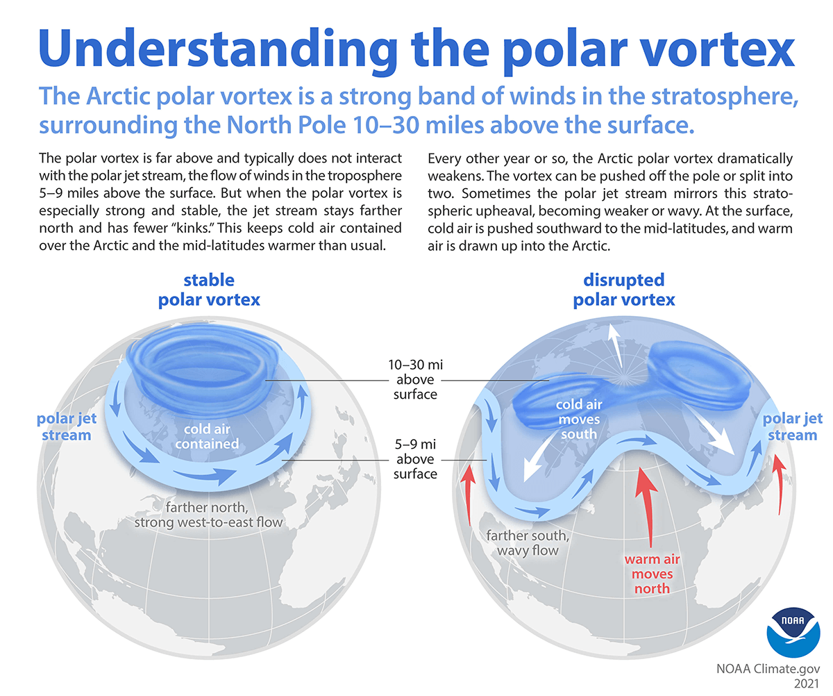
Just to get the science lesson quickly out of the way: Recall that the polar vortex is always there. It’s a permanent feature that typically sits over the North Pole, keeping the hemisphere’s coldest air in the polar region. When we refer to the “polar vortex,” what we’re really referring to is the stratospheric polar vortex, which sits miles above the North Pole but keeps the cold locked in. During the wintertime, every so often something will happen where that cold can be dislodged and dumped into the mid-latitudes leading to cold air outbreaks over the North America, Europe, or Asia. How does that happen? Periodically, you’ll get a warming event in the stratosphere that eventually works downward, first displacing or splitting the polar vortex and then leading to high latitude atmospheric blocking that warms the Arctic and sends cold south. This is what can unleash some of that more noteworthy cold air.
The process is really complicated and fairly often, stratospheric warming does not lead to significant polar vortex disruption. But almost every time there is a warming event, you now hear about it because of what I noted in the opening paragraph.
So what is happening now?
If you look at the forecast weather map today, you can see a pretty anti-winter look in the Eastern half of the country, with very mild air from Hudson Bay south to the Gulf. The West is stormy. Most of the cold is up near Alaska or Siberia and over Scandinavia.
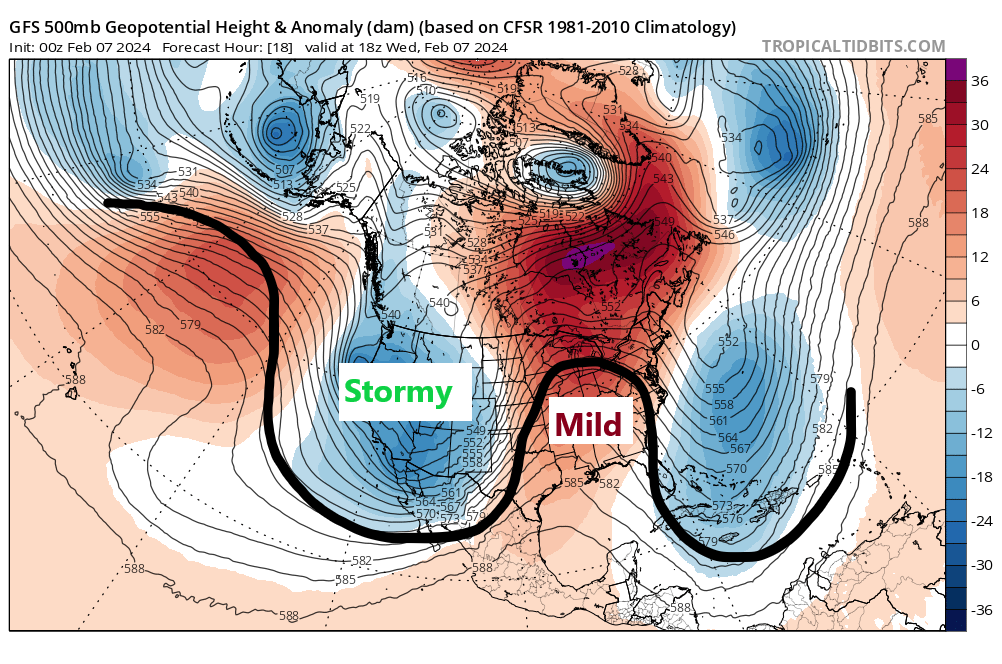
Over the next 10 days or so, this pattern is going to change rather dramatically. The ridging in place from Hudson Bay to the Gulf will weaken. The pretty neutral pattern from Alaska through the Arctic to Greenland is going to block up and warm. This will allow cold to displace back southward into lower latitudes in North America. The real serious cold is probably going to go on the other side of the globe, dumping into Russia and portions of Central Asia. One way to proxy this is to look at the Arctic Oscillation (AO). In a nutshell, the AO is a barometer for high latitude blocking over the Arctic. It’s far more complicated than just using one index to determine the fate of the weather. But in situations like this, it can help.
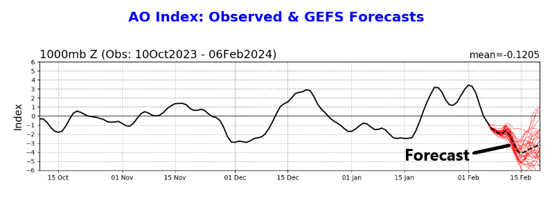
What does it tell us? When the AO is positive, it generally indicates that the Arctic will be cold. It can be assumed most of the time that the polar vortex is sort of in place, in its home over the North Pole. When the AO turns negative, it tends to mean that something has happened in the Arctic that leads to milder conditions and a weaker polar vortex, allowing cold to meander away from the North Pole and toward the populous mid-latitudes. Notice on the chart above that back in mid-January, we had a negative AO, which led to the cold outbreak. Also notice that not every negative AO produces excessive cold! We had a pretty strong bout of negative Arctic Oscillation conditions back in early December, which coincided with Houston’s most recent 80 degree day. We did turn colder after that day, but not excessively so.
Anyway, the AO is forecast to go negative, strongly so around mid-February. This gets a lot of meteorologists’ attention, and justifiably so. It’s a strong signal for strong blocking in the polar region. And indeed, if you look at the Climate Prediction Center’s outlook for days 8 through 14, it shows colder than normal temps forecast over a broad portion of the Lower 48.
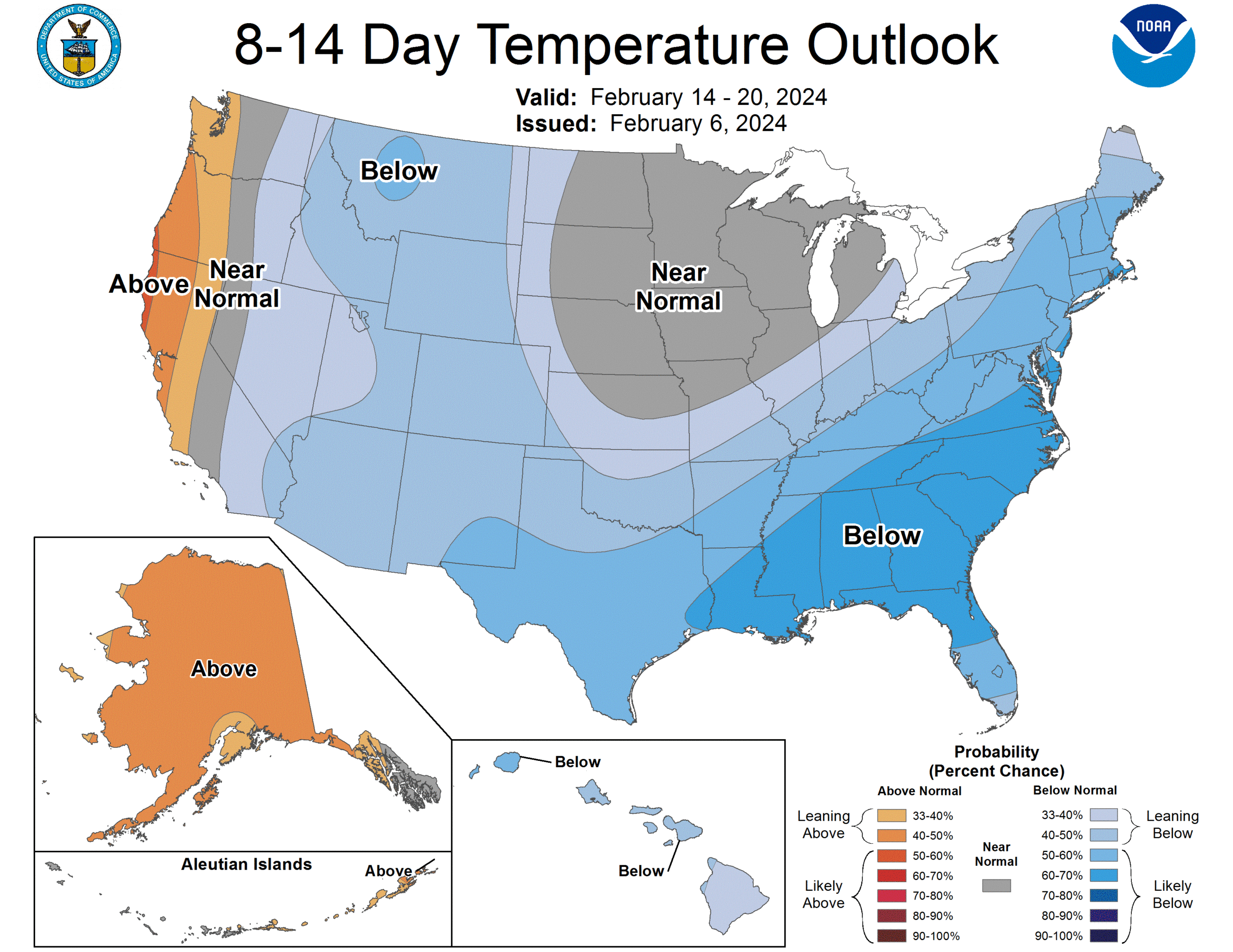
Now, this map is plenty cold for sure. But it’s also moderate confidence. In other words, we’re not super confident in major cold right now. This meteorologist would say we are moderately confident in moderate cold. Frankly, modeling has been a little underwhelming with respect to the cold in mid-February. Some of the modeling that picked up on the ferocity of the January cold early on is not exactly doing so now, though it is forecasting cold. So at this point at least, a repeat of a January 2024-like cold outbreak in Texas seems like a longshot. But it’s going to be cold, and no, we cannot rule out a another (modest) freeze before winter ends.
This setup may be more interesting for the Southeast, particularly with a lot of moisture getting pumped in from California again. If you could perhaps combine some of that moisture into a well-timed low pressure system in the Southeast with some meaningful cold air, we could see some wintry weather in the South or Mid-Atlantic somewhere through late month.

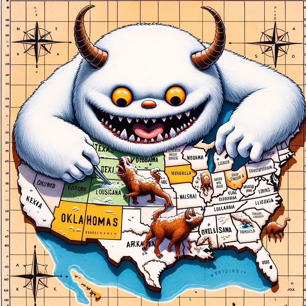
Given the labels on that map, I question ChatGPT’s grasp of cartographics and geography 😀
There also seems to be a fairly major flooding event in northern Mexico.
That tis my favorite part – reflective of disinformation
It’s bad enough that there is one Oklahoma, we don’t need two, and AZ and NM should feel supremely dissed.
AI will not be replacing humans yet.
Hey, Houston weather always has a dip in temps just before the Rodeo, for the trail riders, so may get cool. How cool varies from year to year.
Love that abominable snowman ChatGPT graphic 😛
Interesting. Thanks for the straightforward, understandable explanation
OMG, you guys are great! Absolutely love your graphics!
Keep ’em coming ☺️
🌬 💞💞💞
How about we don’t use AI art
Agreed!
It’s not something we plan to use a lot of, but when given a good opportunity, you have to use an image this absurd.
But I love obviously misinterpreting data regarding something totally outside my field and posting it everywhere on social media…..ooops.
I did like the polar vortex we had in July a few years back – – even more so since I was on vacation in Ohio where it dipped into the upper 40s at night…. slept with the hotel window cracked open. Hey, let’s fill out a requisition for one in August, OK?
Two years ago? Here? In July? Why do I not remember anything at all about this? Heat warped brain, maybe?
Does this also happen over the South Pole?
Yes it does. Same concept, but different impacts because of geography.
It seemed like the GEM had the January cold snap pretty close early on. Way to go eh? Regardless…excellent explanation on PV/SSW/AO and the complexity and their roles. I’m guilty as charged for sometimes jumping the gun…especially on cold air/Winter WX events.
I thought that I was going to loose my peach yield AGAIN this year, but we dodged the freeze here in League City. My tree is in full bloom (thanks to the number of “cold hours”).
I’m begging. PLEASE talk to the freeze gods and put it off for at least another 4-6 weeks. I’ll make y’all a peach blueberry gallette!
Keep up the good work. You are my #1 source for local weather and emergency events.
All I know, is that typically, mid February, we’ll have another freeze. I’ve noticed this for well over 55 years now. There may have been one or two times that it didn’t happen, but for the majority of the years, it has.
Awesome explanation, thank you! Safe to say we may have another freeze…keep an eye on your plants.
This is so fascinating. You guys are awesome!
This is why we usually never start up our new vegetable garden until mid March, because there is always that chance for a late season freeze even in March. Just 2 years ago we had our last freeze on March 13th, 2022. That is fairly uncommon but not unheard of. 5 out of the past 14 years we have had a freeze in March in our region.
Btw some of these years we didn’t see a freeze in February but did in March.
Great explanation in plain English for a non-scientific mind. Thank you.
If you followed Joe Bastardi you would have known about this arctic outbreak weeks ago.
Very well written and described, but it seems that the climate change aspect was left out (i.e. generally understood to be the reason why the vortex has become less stable). I’m not an expert, but I do follow this type of information fairly closely. I know there’s concern about “blowback” from those that see climate change from a political standpoint, but its my hope that respected meteorologists like yourself take the opportunity to explain climate change when an opportunity arises. I know you and Eric have touched on the subject before – I just saw this as another potential teaching moment. Signed, a Space City Admirer
Hi Roger: I’ve actually discussed this with climate scientists and there is not a consensus on the vortex becoming more unstable due to climate change. We try to stick to more firm, well agreed principles like heat and increasing rainfall. We certainly wouldn’t shy away from it. We get blowback for sure, but we both are extremely supportive of mainstream climate science. But in this specific instance (a modest late winter cold snap), it’s simply not really that relevant. We try to pick our battles! You’ll certainly be seeing more on that down the road. Thanks for your support!
Very well stated 👍
Many thanks for the reply and clarification Matt.
I came here for the comments on the AI art 🤔
With all of the billions poured into the fancy radars these days, I firmly believe meteorology was more correct back when AL Roker and Willard Scott simply placed Velcro sun and clouds on the cardboard map…
Meteorology: “The only job you can be wrong 98% of the time, and still get a fat paycheck”. !
The winter vortex comes up in conversation nope just another let’s focus on the most bombastic predictions always. Sad and an untruthful.
Awesome explanation. Thanks so much.