After a wild Labor Day that saw Galveston and coastal communities see upwards of five to ten inches of rain or more, we’re starting with more rain down that way today. But we do have good news for those ready for a break.
Today
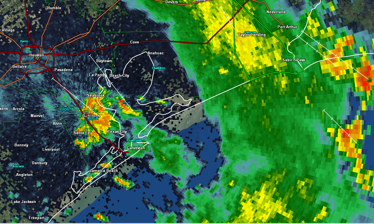
Radar this morning as of showed a narrow band of heavy rain pointed onshore across Galveston Island and the southwest end of the Bolivar Peninsula, now inland as of 5:50 AM to about League City. Additional moderate to heavy rain had prompted another Flash Flood Warning just outside of Port Arthur.

Some of the rain near Port Arthur may try and come a bit west, so folks on the east side of I-45 could see a steady moderate to occasionally heavy rain for a time. Locally heavy rain will continue at times near Galveston, which could cause some relapse in street flooding again. A Flash Flood Watch is posted for the coastal counties through today.
Further inland, including most of Houston, we’ll see a smattering of showers and thunderstorms around the region this morning and afternoon. Look for gradual improvement later today. Clouds and showers will hold back temperatures once again. We only hit 78° officially on Labor Day, our coolest day since the Fourth of July, and only the second time we’ve failed to hit 80 degrees since late April. It feels like it’s been hot forever. Who’s ready for a cold front? We’re looking hard for one, but alas, we don’t see much chance of that happening over the next ten days or so at least.
Wednesday & Thursday
Both days look like a return to more typical late summer weather, with a daily shower and storm chance driven by the sea breeze off the Gulf and daytime heating, so mostly of the hit or miss variety. Any storms will be capable of heavy downpours of course, but coverage should be fairly average for this time of year; a bit less intense than we’ve seen the last couple days. Look for mid- or upper-80s where we see some storms on those days and upper-80s to low-90s in drier locations.
Friday & weekend
With Gordon (see below) passing by to our north, we’ll see a broad onshore flow continue into the late week and weekend. This should mean more scattered showers and storms for that period. Again, hit and miss type stuff, with just a few heavy downpours expected. Otherwise, it should be partly sunny with our typical September lower 90s, or modified pumpkin spice latte weather topped with plenty of humidity. We’ve gotten some questions about being on the “drier” side of Gordon and if that’ll help cool us or dry us out. (Un?)fortunately, Gordon is probably a little too small and too far away to have much impact on our humidity here.
Tropics update: Gordon & friends
The tropics remain very active, and we’re watching a bunch of things. Let’s tick through what’s happening.
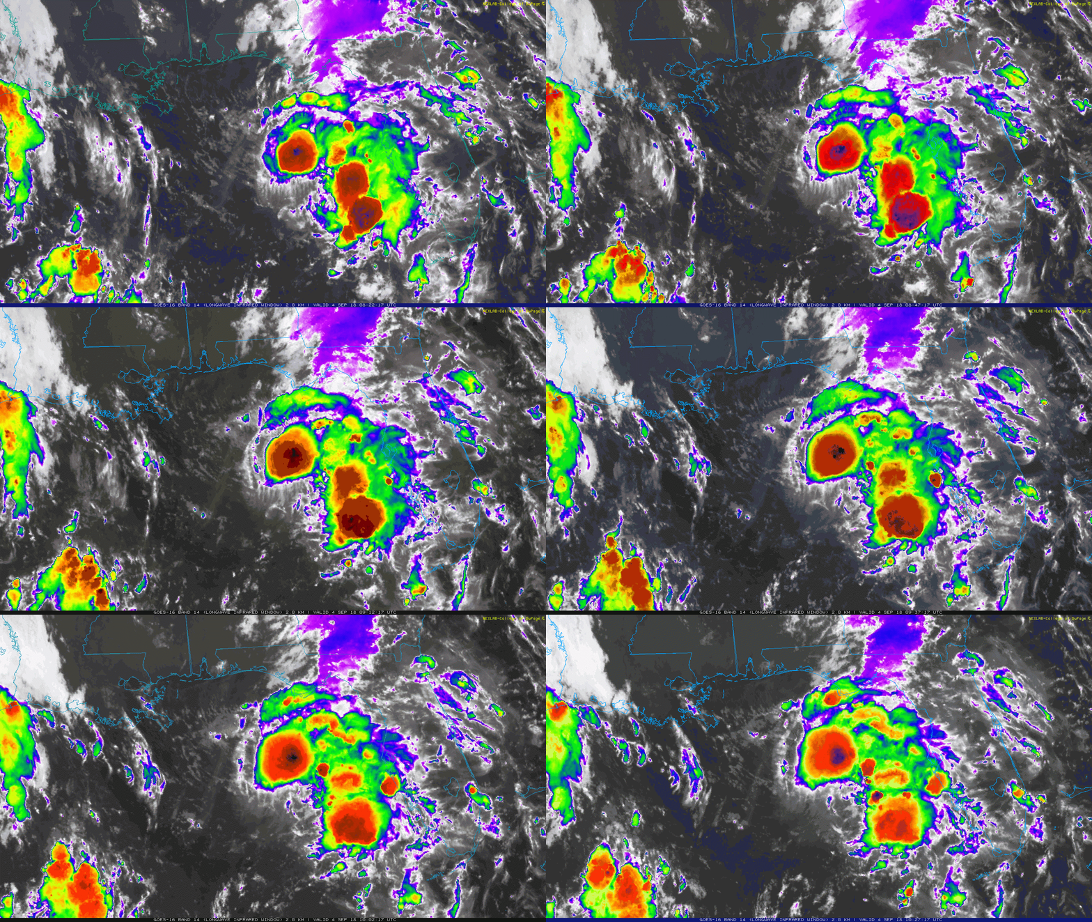
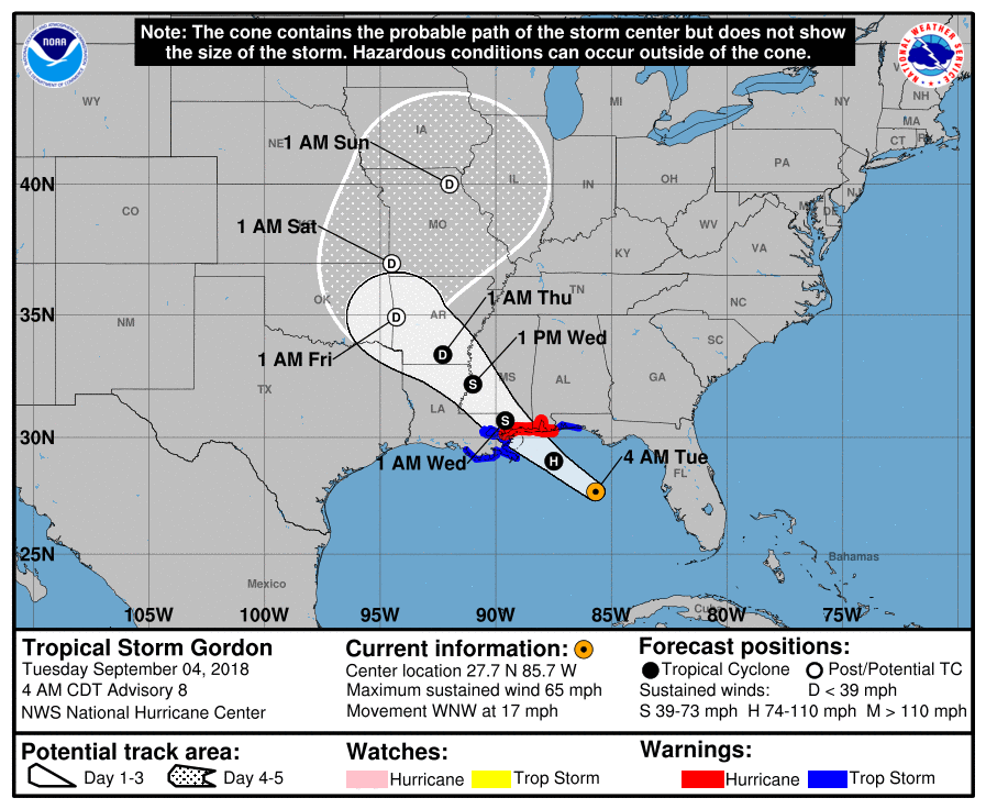
Gordon is a tropical storm still, this morning with 65 mph maximum sustained winds. It’s struggling a little bit due to some wind shear, which has prevented Gordon from achieving its full potential.

Gordon is still expected to briefly attain hurricane strength before it makes landfall, likely east of New Orleans, along the Mississippi coast late today or tonight. Hurricane Warnings are posted east of New Orleans to just west of Pensacola, FL.Tropical Storm Warnings surround that.

Impacts on those locations will be heavy rain and some flash flooding, isolated tornadoes, and probably a 2-4 foot storm surge on the east side of Gordon’s landfall, locally higher. Obviously, tropical storm and hurricane force winds will be possible, especially along and east of where Gordon comes ashore.
Gordon continues to look as if it will pass by well to our north, without any impact to the region. Some good news for us at least.
But behind Gordon, there are a number of systems to watch.
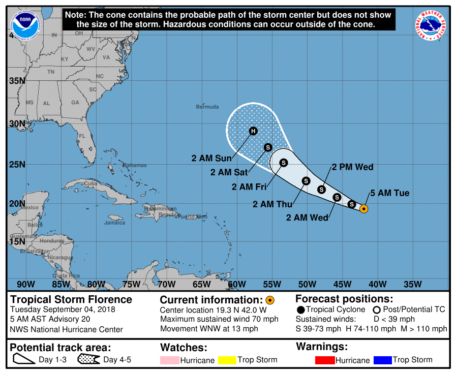
Tropical Storm Florence this morning still has 70 mph winds, but it is expected to weaken a bit over the next few days before restrengthening into a hurricane. As of now, Florence’s track suggests it will likely turn out to sea, but there are a handful of models arguing that there could be a bit of a western turn, bringing Florence closer to the East Coast.

Either way, Florence is unlikely to be of concern to us in Houston. Behind Florence, there is the potential for two more storms in the Atlantic over the next 10 days. The H-storm would be Helene and the I-storm (not a new Apple product) would be Isaac. It’s too early to say where those systems would go, so they aren’t of concern for us today. Eric and I will continue to watch!

Matt: Rob Navias from NASA here….colleague of Eric’s for space coverage. How credible is the GFS model showing a storm right over us here in Houston on Sept. 14? Thank you.
999 mb and fast moving.
Putting it sarcastically, if I had a $1 for every storm it showed over Houston that didn’t materialize, I’d be retired. In all seriousness though, we will need to keep monitoring things in the days ahead, because it wouldn’t be impossible for that to materialize. But that specific solution shown is not worth worrying over. Deterministic models like the GFS are not great tools to use to figure out where storms will go beyond about 3-5 days out.
According to TV/ social media,(few days ago), there was a scenario that had Gordon stalling and dumping a bunch of rain on Houston…Canadian was the only model that had Gordon becoming a hurricane..For a couple of days I was very worried…I knew that these next few days would be a particularly gruesome time window for me to deal with any storm that produced damage.. I would have been executing emergency preparations to protect myself / fur baby / home / property without help..With each day that passed there came more clarity with the forecast, now I’m breathing a sigh of relief..
I wouldn’t be surprised if the TV guys tell us to stay home tomorrow because a tropical storm is hitting Louisiana. Better safe than sorry….
The I-storm…hahaha!! Thanks for starting the day off with a laugh!
Between that and “Gordon & Friends” I was laughing pretty good at today’s report
Last week the disturbance that is now Gordon was only given a 10% chance of development. What happened? Are those early predictions of development of any real value?
They’re meant to be guidance based on the best available data at the time. Like any forecast for a tropical storm or hurricane, it will evolve over time based on changes in the data. There was always a chance it would develop…it just went from a not particularly high chance (but not zero) to a high chance over a couple days. That’s the nature of forecasting tropical storms and hurricanes.
I always took the % chances as what is likely to happen in the next 48 Hours. It is to be expected to increase as time goes on and the storms develop.
NHC has both a 2 day and a 5 day outlook. So you also need to make sure you know which one you’re looking at!
” . . . modified pumpkin spice latte weather topped with plenty of humidity . . . ” I’m dying! 🙂
Yay sun out today Thanks, Matt.
😉 Hopefully, none of us with i-Phones will have to worry about tracking the i-Storm on our i-Weather Apps! I vote that wind shear and cooler Atlantic temps mean i-DEATH for the i-Storm 🙂
Sun out today yay Thanks matt .☺.
What website shows the radar images of the storms in the Gulf and Atlantic? What book would you recommend to better understand the formation and functioning of hurricanes? Thanks.
I personally use tropical tidbits and weather.us, as well as NHC. Hope that helps
Thank you Matt and Eric! You are the ONLY weather I check! Thanks to Reliant for sponsoring such a worthy site! Noticed and appreciated!
Any news or forecast for the first cool/cold front if the season?
We’re desperately searching for it … but no real strong signal yet, sorry.