Starting close to home and working outward this afternoon: Heavy rain to the tune of 6-10″ or more along the immediate coast has caused flooding from Freeport through Galveston to High Island. As of early afternoon, High Island had seen over 11 inches of rain, Jamaica Beach had seen north of ten inches, and Galveston was nearing seven inches so far. This has created waterlogged scenes in Galveston today.
UPDATE: Here’s another look at downtown Galveston – streets around here are flooded, and with the rain not letting up anytime soon it’s only getting higher. Still only knee high at least on me – I’m 5’3. #khou11 #Htownrush #Galveston #houwx pic.twitter.com/cvWY1WaBUP
— Michelle Choi (@MichelleKHOU) September 3, 2018
Business owner working to unclog his drain. Says he’s trying to save the storefront. pic.twitter.com/3RAUOKzfLG
— Josh Marshall (@JoshMarshall_10) September 3, 2018
MEGA TRAFFIC JAM trying to get off the island. Heads up to anyone who needs to leave #Galveston right now. I literally **got out** our our #abc13 SUV, walked along side it, to shoot this video… #snailspace #labordayflood pic.twitter.com/f2K7Q3dmTp
— Courtney Fischer (@CourtneyABC13) September 3, 2018
So what’s to come?
Radar as of 1:30 PM today shows heavy rain gradually diminishing in intensity along the coast and inland.
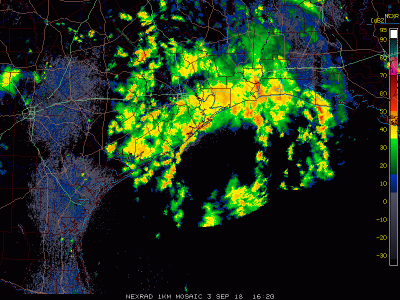
Expect rain to generally wind down here, though some isolated heavier downpours or thunderstorms will be possible into late afternoon. But those would be the exception rather than the rule. Continued residual street flooding is likely to continue in Galveston and generally along the coast.
Tonight
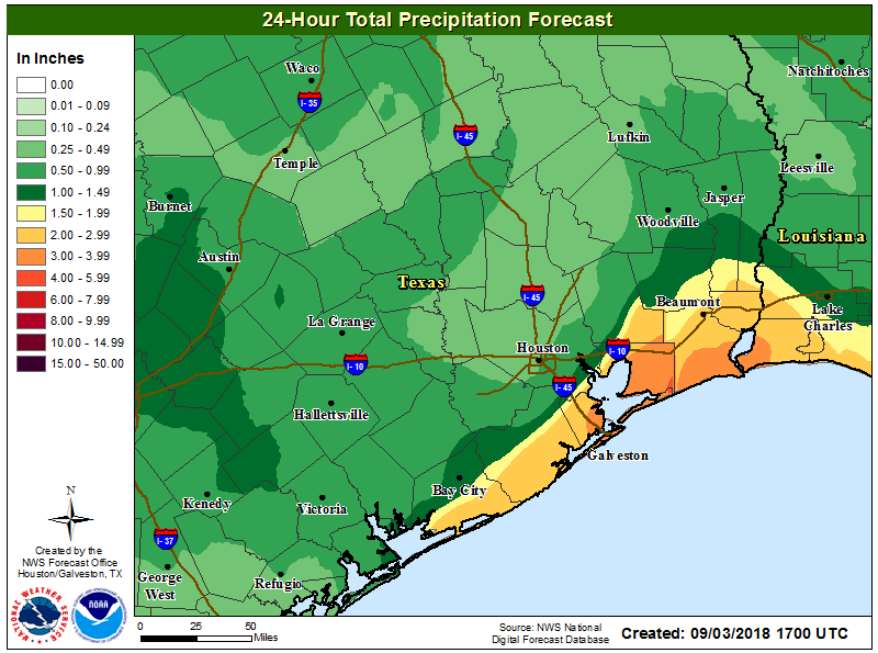
Another round of rain is possible, especially south and east of Houston, so the flooding threat, while perhaps not as great as today, will not quite trend to zero. There’s still a bit of uncertainty in how much rain falls and exactly where, but in general, another inch or two seems possible along the coast, with lesser amounts inland from tonight through tomorrow afternoon.
Things do look to quiet down around here for the middle of the week, though rain chances don’t quite get to zero. More on that tomorrow.

Tropical Storm Gordon
The National Hurricane Center upgraded the potential tropical cyclone to Tropical Storm Gordon this morning. And we may be seeing Gordon show us it wants to become a hurricane before long.
Check out the radar loop this afternoon from off Florida between about 11:25 and 12:25 PM CT.
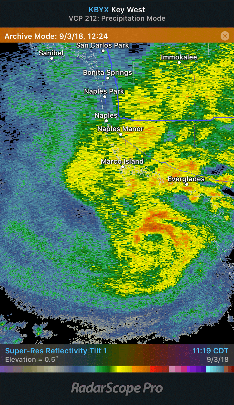
Gordon quickly went from a formidable looking tropical storm to a very ominous one in the course of an hour. You don’t see this very often, at least not this well with the technology we have available to us today. Anyway, look for forecasts for Gordon’s intensity to likely trend stronger as we go through today. Right now, Gordon is presumed to have 50mph maximum sustained winds. The intensity will fluctuate over the next couple days, and again, it’s possible Gordon attains hurricane status at some point.
As of this afternoon, Hurricane Watches are posted from just northeast of New Orleans to the Alabama/Florida line. The forecast track of Gordon hasn’t changed much, and it is still anticipated to track into Louisiana or Mississippi tomorrow night, likely as a high-end tropical storm or (given recent trends) a hurricane.

The latest advisory on Gordon will be released around 4 PM CT, so we’ll get an update then. You can check the National Hurricane Center website for the latest.
As Eric laid out this morning, risks in the Houston area are minimal. We do not expect direct impacts from Gordon here as of now, except for perhaps a little bit of an increase in rain chances late this week. There’s been little no change in expectations since this morning for us. If you have friends or family from New Orleans to Pensacola, it would be wise to encourage them to take Gordon seriously. Impacts there will begin tomorrow and should wind down later Wednesday. We’ll continue to watch and have more in the morning.
Now up to 2″ for the day around Ellington.
Is there a “No Hype” equivalent of you in New Orleans? I’m needing thoughtful analysis of Gordon, but I need a local to New Orleans source, if possible.
I don’t know of any equivalent to us there, but I do recommend following the NWS New Orleans. I know several of the meteorologists there, and they do very good work. On Twitter, I also recommend Kweilyn Murphy (https://twitter.com/KweilynWDSU) and the Times Picayune hurricane reporter, Mark Schleifstein (https://twitter.com/MSchleifstein).
thank you!
Same question, but for Austin?
Nice, slow but steady and much needed soaking rain in Alden Bridge in The Woodlands. No irrigation needed this week!
Thanks Matt, how is the little one?
We’re all holding up great, thank you!
Kudos as always gentlemen for the thoughtful, well-written updates and analysis. Spacecityweather.com, by choice, is literally my only weather news source.
Also many thanks to Reliant Energy for their sponsorship. It is noted and appreciated.
Thank you for reading, Dom!
Will this storm be too far to our east to give us those beautiful pink sunsets we’ve previously seen?
Tough to think it’ll be close enough to give us those. But, given the tropical air mass overhead, I think we might pull out a couple decent sunrises or sunsets this week.
Since we’ll be on the west side of Gordon, can we also expect to see our winds shift out of the north and maybe a little cooler, drier air? Wishful thinking?
Cooler, no…drier, perhaps. The rub this time of year is that if you have a strong enough storm to our east, you can dry out the humidity a bit, but instead of 90-95 and humid, you get 95-100 and not much humidity. Pick your poison, I guess?
Sounds like Gordon will be a non event for us – pretty close to the European model prediction a week ago. In this light, I am a bit concerned about my daughter outside Savannah, GA about a week from now as the model shows a monster storm in her vicinity. Do the other models seem to agree?
Models are very mixed about what becomes of Florence, which would be the one that may get close to Georgia. Honestly, I think it will not get there. But a lot of uncertainty. Just to be fair, as good as the European did when you looked at it, on Friday night and Saturday it took Gordon and brought it to Houston, stalling it for a day or so, dumping a lot of rain. It appears that will be wildly incorrect, so as good a reputation as the European model has among folks, it’s prone to occasionally significant failures from time to time too.
Thanks again for the “no drama” forecasts. You guys put the commercial networks to shame! You guys were with us thru Harvey and we really appreciate everything.
Now, get a cable channel and put some real weather on it!!!
Wunderground.com now has Gordo making landfall as a Cat 1.
I am stuck on Galveston – floods have receded in the Strand area, but AAA isn’t running tow trucks yet. What do you think tonight’s storms will bring to the island?
Tonight’s rains shouldn’t be what we saw last night, but obviously, given how much fell, it wouldn’t take a lot for flooding to start up again. That said, as of right now, another inch or two of rain would be expected, which could lead to mostly minor flooding. And that won’t kick up until after midnight most likely. So water will continue to recede the next few hours.