In brief: The first of several cold fronts will arrive in Houston today, bringing with it a decent chance of rain and possibly a few storms. We’ll warm back up on Saturday before another, stronger front knocks most of Houston into the 30s by Monday of next week.
Wednesday
After an abnormally warm start to the month, Houston will see the first substantial frontal passage of February later today. We can expect a (probably broken) line of showers and thunderstorms to move through the area this morning before noon, from west to east, before drier air moves in from the northwest this afternoon. I don’t expect anything too wild and crazy from the rain showers, but it’s Houston so be prepared for the possibility of some thunderstorms and briefly heavy rainfall. Highs today will crest at about 70 degrees this morning before dropping into the 60s this afternoon, and the 50s this evening.
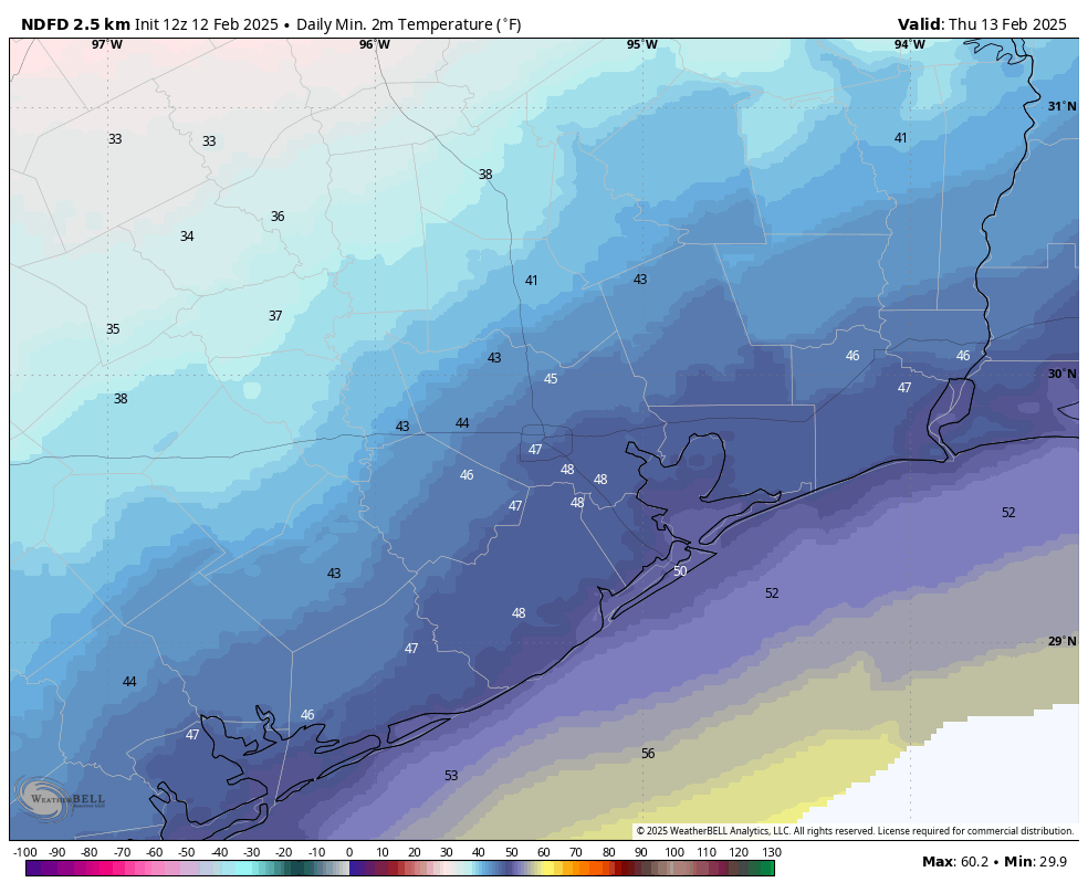
Lows on Thursday morning will fee more seasonable across Houston. (Weather Bell)
Thursday
Lows on Thursday morning will be in the low 40s, and with a chilly northerly flow expect high temperatures to only climb into the mid-50s. We will see mostly sunny skies, however. Lows on Thursday night will drop into the 40s as winds turn more easterly.
Friday
Skies will be partly sunny on Friday, with highs likely climbing into the mid-60s. As atmospheric moisture levels rise we could see a few scattered showers develop later in the day. Friday night looks to be mild, with lows only dropping into the upper 50s or lower 60s.
Saturday
Humidity levels will spike on Saturday, with high temperatures likely pushing toward 80 degrees as we see a surge of warmer air ahead of the next cool front. Although the timing is still a bit uncertain, this front likely moves through on Saturday afternoon or evening, and it should bring a chance of showers and thunderstorms with it. We’ll see about the dynamics for storms, but right now they don’t appear to be overly favorable in the Houston metro area. Lows on Saturday night are likely to plunge in the wake of the front, dropping to about 40 degrees.
Sunday
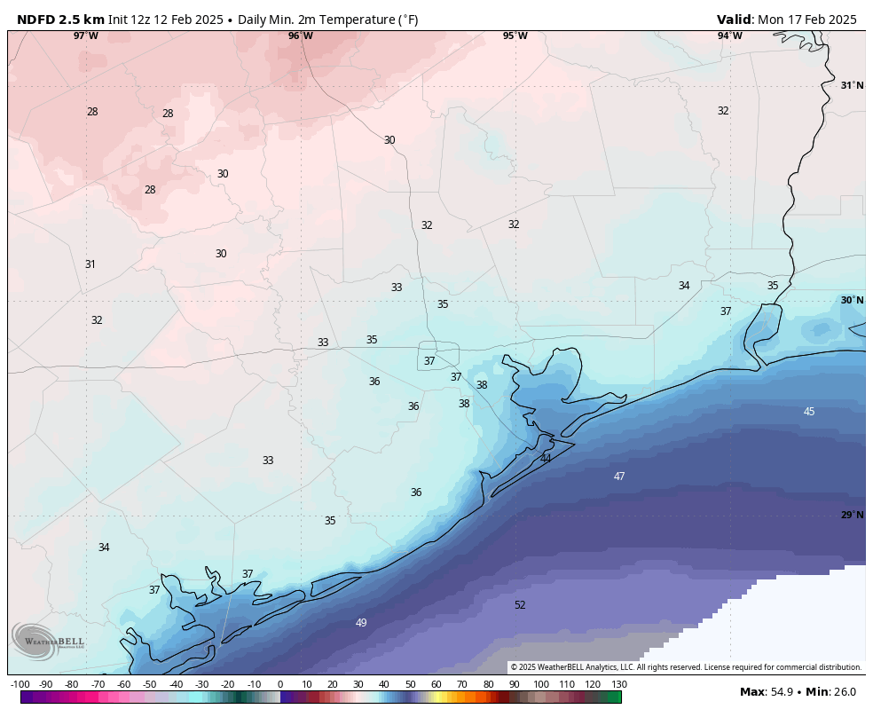
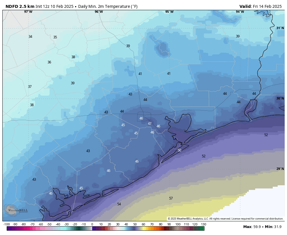
Expect clear, sunny, and cold conditions with high temperatures of around 50 degrees. Lows on Sunday night will drop into the 30s for much of Houston, and we cannot rule out a light freeze for some inland areas.
A light freeze is possible on Monday morning for parts of the Houston metro area. (Weather Bell)
Next week
We’ll be chilly on Monday and Monday night before a warmup next week, followed by what appears to be another fairly strong cold front on Tuesday or Wednesday. This will, once again, bring the chance of a light freeze to Houston by Thursday morning or so. Winter is not over yet.
In brief: Today’s post discusses the likelihood of widespread rainfall today and Wednesday ahead of the first of several decently strong cold fronts. Speaking of which, there’s the possibility of a freeze over the next 10 days, so we don’t advise planting tender plants just yet.
Winter is not over yet
Houston has had an anomalously warm start to February, with an average temperature of 72.1 degrees. This is a shocking 16.2 degrees above normal through the first third of the month. Beginning Wednesday we’re going to enter a cooler, more seasonal pattern. Looking ahead, global models are pointing to the possibility of two stronger cold fronts next week.
The first of these arrives Sunday, and the second possibly by next Thursday or so. One or maybe both of these could drive Houston’s lows into the 30s, and there’s a distinct chance of a light freeze about 10 days from now. I’m not saying it will happen, but it’s definitely possible. So hold off on gardening for a little while longer.
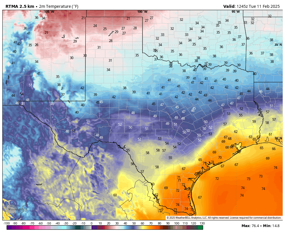
Texas is experiencing all four seasons this morning, in terms of low temperatures. (Weather Bell)
Tuesday
Today is likely to be a fairly wet day. We don’t really have any significant flooding concerns, but streets could pond over amid some of the stronger showers or thunderstorms. The rain will be somewhat scattered this morning before showers become more widespread this afternoon as the atmosphere turns unstable. Showers will likely peak in coverage this afternoon before rain chances diminish somewhat overnight. This won’t be the end of the rain, as we are likely to see another round of showers on Wednesday morning along with the front.
Temperatures this morning are generally in the upper 60s across much of Houston, and they’re going to remain there all day with cloudy skies and the potential for rain. Winds will be gusty, varying from the south, east, and northwest. Lows tonight will only fall into the low- to mid-60s for most locations.
Wednesday
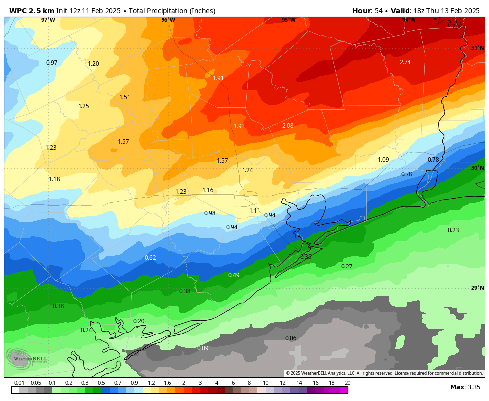
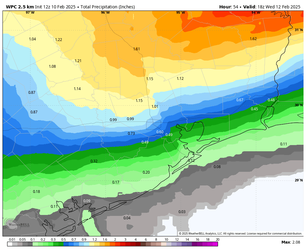
Additional showers are possible on Wednesday morning and into the early afternoon hours, ahead of the actual cool front. Between now and Wednesday afternoon I expect most of Houston to receive 1 to 2 inches of rainfall, although amounts could be a little bit higher for areas well inland, including The Woodlands and points north. Highs on Wednesday will be in the upper 70s for most before drier air moves in during the evening hours. Temperatures will start to fall before midnight, and by early Thursday morning temperatures for most of the area should dip into the upper 40s.
NOAA rain accumulation forecast for now through Thursday morning. (Weather Bell)
Thursday and Friday
These will be a pair of partly sunny days, with highs in the upper 50s to lower 60s. Thursday will see gusty, northerly winds and Thursday night will be quite chilly, in the low- to mid-40s. Friday night will be a bit warmer, in the 50s, as the flow turns more southerly.
Saturday
A warmer day, with highs in the mid-70s. We’ll again see the potential for some widespread (mostly light?) showers ahead of the next front. Accumulations don’t look overly impressive, but bear in mind the potential for rain if you’re planning outdoor activities. Colder air likely arrives overnight, pushing lows on Sunday morning into the 40s.
Sunday
Sunshine returns for the second half of the weekend, but with a colder, northerly flow high temperatures will likely be in the 50s. Lows on Sunday night could drop into the upper 30s in Houston, give or take. We’ll see.
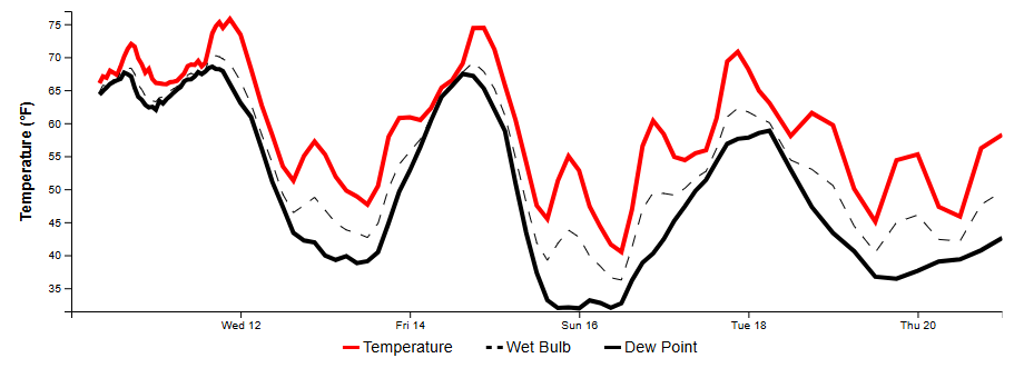
Houston’s temperatures and dewpoints will be riding quite the roller coaster for the next 10 days. (National Weather Service)
Next week
Our roller coaster weather rolls on, with highs by the middle of next week likely rebounding into the 70s. However, most of our guidance points toward a fairly strong front for the second half of next week. This is when I think there’s at least a decent chance to see a widespread freeze in Houston.
In brief: Today’s post looks ahead to when Houston will start to feel more like winter again (the answer for most of us is Thursday morning). Additionally, with the potential for significant budget cuts on the horizon, we discuss how NOAA and the National Weather Service provide considerable value.
The value of the National Weather Service
There has been a lot of talk about cutting the US government via the “Department of Government Efficiency,” which is ostensibly assessing the performance of each US agency to improve its output. There are a lot of strong feelings about the actions of this body, spearheaded by Elon Musk, and it is beyond the scope of this website to judge its value. Suffice it to say we believe there is bloat in the US government that ought to be addressed, but at the same time US agencies provide valuable services, and most civil servants are trying to do the right thing.
This morning I want to write a few words about the value brought by the federal government’s weather and climate agency, NOAA, in general; and one of its organizations, the National Weather Service, in particular. We strongly believe that NOAA and the National Weather Service provide tremendous value to American taxpayers that cannot easily be replicated by private companies—most definitely including Space City Weather.
NOAA collects an extraordinary amount of data about our planet’s atmosphere and oceans every day. They send hundreds of weather balloons into the skies. They have a vast network of buoys and weather stations. They operate state-of-the-art radars. When there is a hurricane, NOAA and its partners operate a fleet of aircraft and professionals that fly into the maw of the storm to gather vital data that is used to make warnings, and improve forecasts.
It not only collects this data, but NOAA plays an important role in weather modeling, operating one of the world’s premiere computational forecast systems. Moreover, its high-resolution models are vital to predicting thunderstorms and severe weather on a local scale, as well as the evolution of hurricanes. Matt and I use these high-resolution models every day. And NOAA shares all of this data and information, for free, with the world to improve weather prediction.
During hurricane season, much of the world looks to the National Hurricane Center in Miami for actionable information. But within NOAA there is also the Storm Prediction Center, which forecasts tornado outbreaks and other severe weather; the Weather Prediction Center, which forecasts rainfall amounts; and of course the National Weather Service, which has offices around the country, including one in the Houston-Galveston area. Dedicated meteorologists there provide around-the-clock forecasts and issue life-saving warnings. Matt and I know these people, and they work really hard for all of us.
Local decisionmakers and Emergency Management System officials in every city and county in America rely on local forecast officers for everything from closing roads and schools, to calling for evacuations and or opening cooling centers, and so much more.
So can’t we just privatize all of this? Not easily. Most private weather companies do not collect essential data about our atmosphere or oceans, or issue public warnings. Typically, they provide proprietary forecasts that tailor and fine-tune public information for specific applications beyond the core mission of the National Weather Service. No private company could provide high quality forecasts if not for the data that NOAA freely disseminates.
What about just getting forecasts from the app on my phone? Well, a lot of the weather apps on your phone are serviced by back-end data provided by the National Weather Service (including ours), or the models operated by NOAA. And those fancy radars on your phone telling you when to stay put? Those are operated by NOAA.
The bottom line is that it would be a bad idea to take a hammer and start whacking NOAA and the National Weather Service. If there is bloat, or fraud, or waste, by all means root it out. But if we destroy the core mission of these valuable federal weather services, we will all lose.
Monday
Temperatures this morning are somewhat cooler, with a weak front having pushed into Houston and all the way down to the coast. The key word here is weak, and the front’s impact won’t last for long, especially for areas south of I-10. With that said, temperatures today will generally be in the upper 60s, with cloudy skies helping to keep us on the cooler side. Winds will be out of the east this morning, but should gradually turn southeast this afternoon and evening, and this southerly flow will only allow lows to drop into the low- to mid-60s for much of Houston.
Tuesday
Weather on Tuesday will be warmer and more dynamic. Highs will reach near 80 degrees for much of the area, with mostly cloudy skies. There will be a chance for some light showers on Tuesday morning, with an increasing chance of rain and the potential for some thunderstorms on Tuesday afternoon and evening as the upper atmosphere becomes more perturbed. Rain chances slacken a bit Tuesday night, with lows dropping into the upper 60s.
NOAA rain accumulation forecast for now through Wednesday morning. (Weather Bell)
Wednesday
This will be another warm day, with highs in the 70s to 80 degrees. We’re going to see another chance of showers and thunderstorms ahead of a cool front, which should arrive later in the day. It is not entirely clear how long it will take the cooler and drier air to move down through the area, but Wednesday night will be notably cooler for areas inland of Interstate 10, with cooler air probably coming in for coastal areas later.
Thursday
This will be a notably cooler day, with highs likely topping out in the upper 50s, with a mixture of sunshine and clouds. We can’t rule out a few lingering showers. Lows on Thursday night will probably drop into the 40s.
Lows on Friday morning should finally feel winter-like again for all of Houston. (Weather Bell)
Friday, Saturday, and Sunday
At this point, it looks like we’ll start warming up again on Friday and especially Saturday, with highs climbing back into the 70s by Saturday, with rising humidity levels. Another cold front appears likely to pass through the area on Saturday night-ish, which will push us back into winter-like temperatures on Sunday, with highs likely only in the upper 50s or so. The details on this are a bit fuzzy, but basically Saturday should be warm, and Sunday quite a bit cooler with a better chance for clear skies.
Next week
Our roller coaster weather continues, most likely, with a succession of fronts bringing varying weather conditions from spring- to winter-like. Several readers with itchy gardening inclinations have asked about the likelihood of another freeze in the Houston area this year, and that’s a topic I’ll address in tomorrow’s post.
In brief: Houston’s rinse and repeat of periodic fog and very warm, humid conditions will continue through at least Sunday. Rain chances nudge up a bit next week, and we still suspect a front may eventually, possibly arrive here later in the week. We also dive in further on sea fog today.
More on sea fog
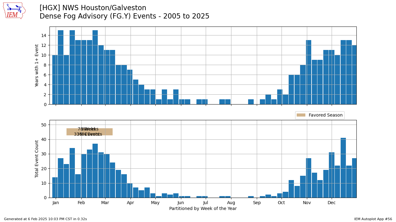
Eric’s talked a lot about sea fog this week, and it remains a pestilence across the coastal waters. Galveston finally broke free of fog for a while late yesterday. But, it’s back now. And if you’re asking yourself whether or not this is normal, the answer is actually yes. February and December are our two biggest fog months in Houston, particularly near the coast. Why? As Eric explained earlier this week, the process of sea fog involves cool shelf waters and warm, humid air crossing over them. In December, it’s a combination of our first cold of the winter, followed by a warm-up. Or it could be driven by non-sea fog, or what we call “radiation fog,” which is just fog that happens over land due to radiational cooling under clear skies at night, not the advective sea fog. The key difference? Radiation fog usually dissipates by mid to late morning. Sea fog may stick around or appear at random points during the entire day.
Over the last 20 years, the frequency of dense fog advisories in the Houston area (bottom panel above) has a double peak, first in December and then again in February through early March. (Iowa State Environmental Mesonet)
February usually marks the transition to spring, and the cold of winter has taken its toll on the shelf waters just offshore. The combination of that first taste of spring-like warmth and the cold Gulf water happens most often between February and early March. Once we get to mid-March, the cold spells usually relax, the shelf waters begin to warm, and the mechanism for sea fog disappears. Thus, the frequency of dense fog advisories plummets.
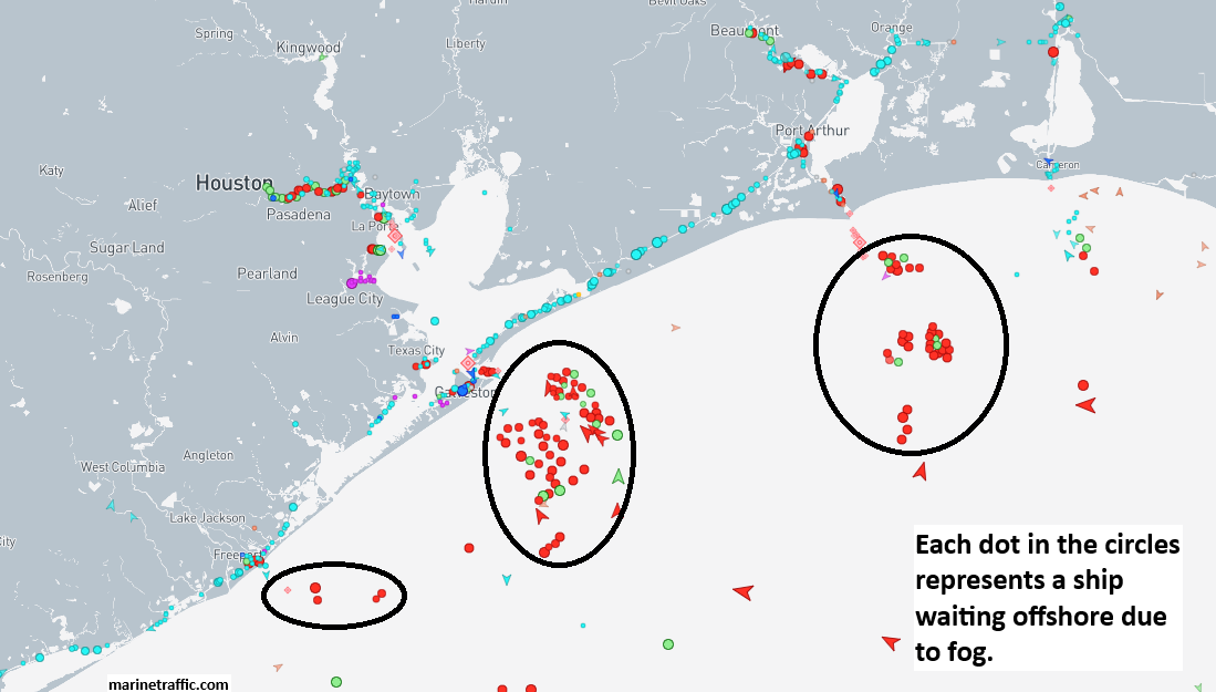
Dozens of vessels are waiting offshore of Texas and Louisiana to come ashore. In addition, many are likely stuck in port too awaiting departure. (marinetraffic.com)
My previous day job role in the LNG industry required some serious fog forecasting chops, and let me tell you, for those operating or running critical businesses in Gulf Coast ports or forecasting for them, these events are full of stress. I have likened the stress of working a one-week fog event to that of the stress involved with forecasting a hurricane. You can click here to view a near-real time ship traffic map. Notice the clusters of ships amassing off the coast? They’re waiting to arrive in ports like Houston, Beaumont-Port Arthur, Sabine Pass, etc. Harder to see are the numerous vessels also “stuck” in port that have to depart. Each day lost to fog can cost companies tens of millions of dollars or more. Stack it up over a week, and you can do the math. It’s a lot of money. No pressure.
Today through Sunday
Does it end? How many more records can we break? This is the 6th warmest four day stretch on record in winter (December through February) in Houston. We’ve averaged about 75.1° so far this week. The record for four days is 76.4° set back in December of 2021. Yesterday was our fourth consecutive record high (83°), breaking 2019’s 82°.
Today’s record of 86° from 2017 seems safe. Clouds and fog should again hold us back a bit, so again look for low-80s for highs. Tomorrow? It may be a tick or two warmer, but the record of 87°, also set in 2017 would appear safe at the moment. Let’s not forget Super Sunday! More of the same. Another day in the low-80s, which is hopefully around the same value as Patrick Mahomes’s passer rating. Fly Eagles, Fly!
As for the fog, look for continued chances of afternoon or early evening clearing at the coast and a bit less inland fog than we’ve seen this week. Still, it will be around, and it will be dense at times, so use caution driving particularly in the morning hours.
Next week
The first attempt at a cold front will actually occur Sunday. The front may sneak into the Brazos Valley or as far south as Huntsville or even Conroe. It won’t severely knock back temperatures, but it could cool things temporarily up that way by 10 degrees or so. It appears that the front retreats back north Monday and Tuesday before maybe finally making a swipe at the area Wednesday or Thursday.
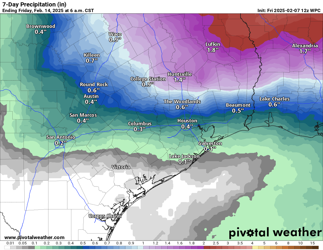
While there are showers and a chance of thunderstorms in the forecast next week, the total rainfall expected in our area is not particularly noteworthy. (Pivotal Weather)
We may begin to see more showers crop up each afternoon starting Tuesday. That could transition into a better chance of showers and storms by Thursday, pending an actual front getting here. I would not get too worked up about rain chances at this time; they don’t look too exciting. Still, we’ll see how the weekend changes affect that story Monday.
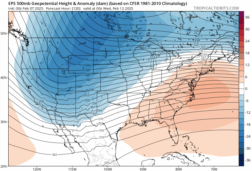
A stubborn, warm Southeast ridge (red and orange over the Southeast) will be battling some brutal cold up in Canada and the Upper Midwest. We’ll probably turn colder at times but probably not to serious freeze-territory. (Tropical Tidbits)
How cold will it get behind the front? Well, at this point, we’re fighting a battle between very, very warm conditions over the Southeast and very, very cold conditions up north. Western Canada looks to get punished next week. The forecast high temperature in Calgary from the European ensemble next Friday is -22 degrees. It may not get any warmer than minus 20 degrees there on a couple days. Will any of that cold get down here? A modified version of it might later next week, but I don’t know that we see even a widespread light freeze at this point. For now, expect a couple rounds of more muted cold here into mid-February with details to be sorted out next week.