Good morning. Houston remains on track for a decidedly cooler and wetter week, with the major question facing us being how much rain the region will receive. For now, I’d expect most locations in the Houston metro area to pick up 1 to 3 inches between now and Friday. The higher end totals, generally, will come near the coast, with lower-end accumulations for inland areas north of Interstate 10.
But there remains a lot of uncertainty as a broad area of low pressure moves westward across the Gulf of Mexico, toward the Texas coast. Given this, the region could see quite a bit more rain, or rain totals could underperform. If you’re wondering about the holiday weekend, sunnier and hotter weather should return by Saturday or Sunday, ahead of the Fourth of July.
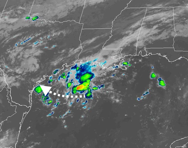
As of Tuesday morning the bulk of the tropical low’s storms are offshore. That will change as it moves closer to Texas this week. (NOAA)
Tuesday
The cool front that moved through on Monday and generated showers and thunderstorms for parts of the metro area has moved offshore, and that’s where the bulk of the rain will fall today. I expect inland rain chances of only about 10 to 20 percent, with slightly higher chances right along the coast. Skies will be partly to mostly cloudy today with highs in the low- to mid-90s, and light northeast winds.
Wednesday
Rain chances start to tick upwards on Tuesday night into Wednesday as the aforementioned low-pressure system in the Gulf of Mexico starts to slowly approach the Texas coast. Still, I’d only peg rain chances at about 50 percent for the coast, with diminishing chances for inland areas on Wednesday. Again, the bulk of the rainfall should remain offshore. Look for high temperatures in the low 90s and mostly cloudy skies, with light northeasterly winds turning easterly.
Thursday and Friday
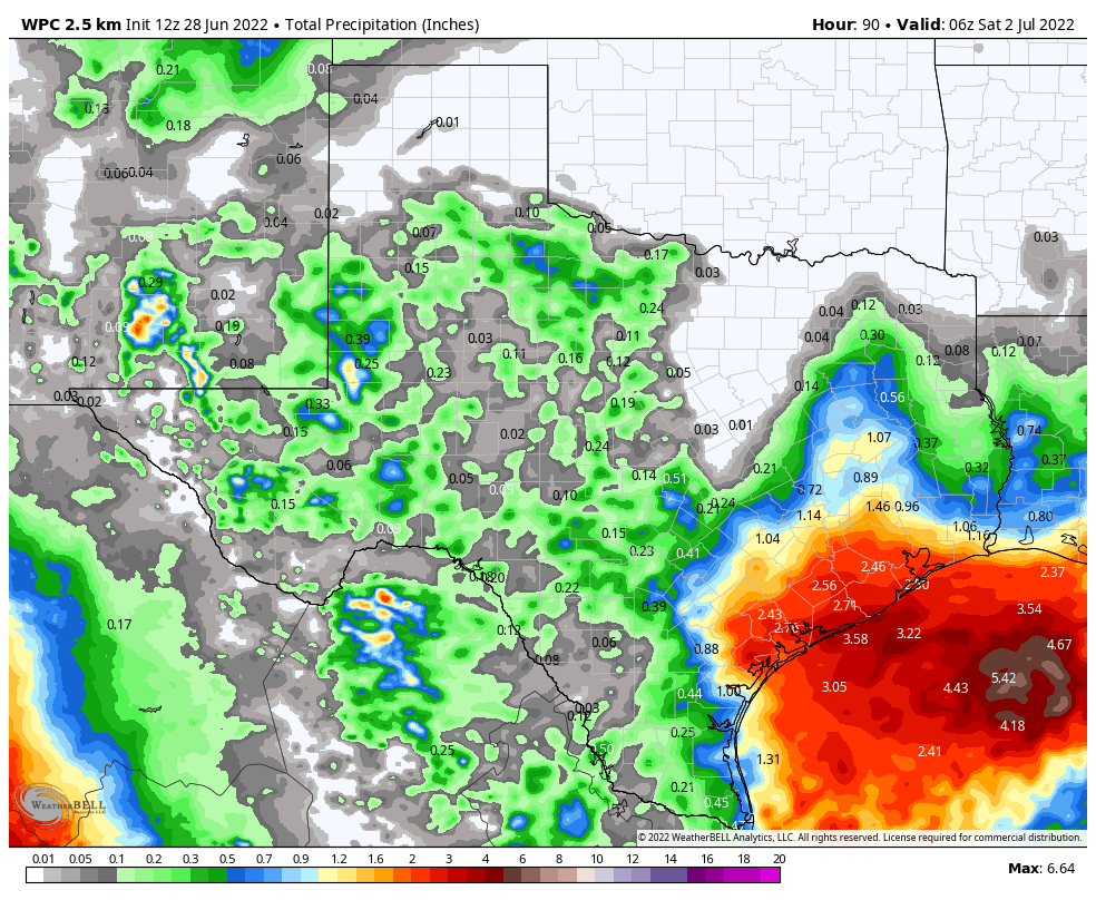
This is when the potential for heavy rainfall will peak. The key questions are where the tropical low pressure system goes, and whether it gets organized into a tropical depression. The low itself is likely bound for the south or central Texas coast. If it organizes sufficiently, this would tend to bring the heaviest bands of rainfall closer to the center of the storm, and south of Houston. If the low remains disorganized, the potential for heavy rainfall would cover much of the Texas coast, including the Houston metro region. As of this morning, the National Hurricane Center is giving the system a 30 percent chance of developing into a tropical depression or storm. Regardless of what happens, we do expect to see at least some precipitation as the upper Texas coast will fall on the eastern, or “wetter” side of the storm. The question, again, is how much.
NOAA rain accumulation forecast for now through Friday. Subject to significant change. (Weather Bell)
High temperatures will depend on the extent of rain, so look for anything from the mid-80s to 90 degrees on both days, with mostly cloudy skies.
Saturday and Sunday
For now it appears as though the low and its attendant rainfall will be largely gone by the weekend, setting up a pair of partly to mostly sunny days with highs in the low- to mid-90s. I’m not ready to rule out rainfall, given the uncertainty over the next couple of days, but chances are probably in the 20 percent range, especially after Saturday morning.
Next week
By the Fourth of July, on Monday, I am reasonably confident that we’ll see mostly sunny skies and highs in the mid-90s. This is fairly typical weather for early July. Such conditions should prevail for most of next week.
Tropics
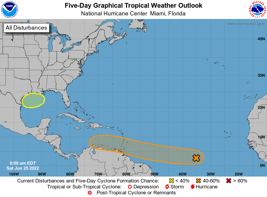
Beyond the Gulf of Mexico there is a lot going on in the tropics for late June, but none of this is a direct threat to Texas. Matt will have a full rundown for you in a tropics update later today.
Good morning. Houston has been exceptionally hot and dry—in terms of rainfall, not humidity—for the last four weeks. Our weather has largely been dominated by more or less intense ridges of high pressure. This week there will be two features driving up our rain chances, and bringing temperatures more in line with the “early summer” period.
The first feature is a cool front that will move down to the coast and stall today. Then, by the middle of this week a low pressure system over the gulf of Mexico should approach the Texas coast. This will bring a fair amount of rain to coastal areas of the state, but it remains to be seen whether the bulk of that rainfall drops over the Houston metro area, or further down the coast.
Finally, a quick note to App users: We have fixed a bug that did not display the latest posts. Please download the latest version to fix this, and thank you for your patience.
Rain accumulation forecast for now through Friday. This is definitely subject to change. (NOAA)
Monday
For a change, skies today will be partly to mostly cloudy, and this should hold high temperatures to the mid-90s. The front will bring scattered showers to areas primarily north of Interstate 10 later this morning and during the afternoon, with the focus shifting to the coast this afternoon and evening. Stronger storms, generally, will be more likely near the coast. I think about 40 percent of the area will see rainfall, with a few isolated areas picking up an inch or so, and most of the rest a tenth of an inch or two. Winds will be out of the west this morning, turning to the northeast after the front’s passage. Lows tonight will drop into the mid-70s.
Tuesday
Skies will be partly sunny on Tuesday, with highs likely only reaching about 90 degrees. Rain chances look pretty low for inland areas, but for locations south of Interstate 10 I think there’s perhaps a 20 or 30 percent chance of rain. Light northeast winds will shift to come from the east.
It is possible we’ll see highs in the 80s by Thursday. (Weather Bell)
Wednesday, Thursday, and Friday
As noted in the introduction, our weather during the second half of the work week will largely be determined by the movement and strength of a low-pressure system over the Gulf of Mexico. There remains only a small chance this system, presently south of Louisiana, will develop into a tropical depression, so the primary weather we’re going to see from it is rainfall. At this time Matagorda Bay seems a more likely bet for the heaviest rainfall than Galveston Bay, but this system will be bringing a lot of atmospheric moisture to the coast, so we will see.
What we can say is that Wednesday, Thursday, and Friday all have the potential for moderate to heavy rainfall, and that chances of this are significantly higher if you live near south of Interstate 10, and even better the closer you live to the coast. I’d guess areas south of Interstate 10 end up seeing 1 to 4 inches of rain this week, and areas north 0.5 to 2 inches. However, this is a dynamic situation and forecasts will change. Highs will range from the mid-80s to 90 degrees depending on cloud cover and rainfall.
Saturday, Sunday, and July 4th
The weekend looks warmer and sunnier, with highs perhaps in the low- to-mid-90s and diminishing rain chances. At this point the Fourth of July holiday looks to be hot and mostly sunny, but there are no guarantees this far out.
There’s a lot of action in the tropics for late June. (NOAA)
Tropics
Beyond the weak Gulf system, there are two other tropical waves worth watching. The area in red, Invest 94L, looks to be bound for Central America. The other wave’s track is less certain, but at this time I don’t think it’s a threat to the Gulf of Mexico either. For now, therefore, our focus will remain closer to home.
We’ve been mentioning the possibility of some elevated rain chances beginning on Monday of next week, and now the forecast is coming into slightly better focus.
A surface cold front will move off the northern Gulf coast into the Gulf of Mexico this weekend, and once there it may find favorable conditions for some kind of development. We think it probably will remain a low pressure system, but there is a chance it could become a tropical depression or even less likely, a tropical storm.
The National Hurricane Center gives the Gulf blob a 20 percent chance of becoming a tropical depression or storm.
Given the steering flow at present in the Gulf of Mexico, and retreating high pressure over Texas, this low-pressure system will most likely track westward across the Gulf. This would bring increasing rain chances to the upper Texas coast, including Houston, beginning later on Monday and through Wednesday. I must stress that at this time these rains look nothing but beneficial for our parched region.
Accumulations are nearly impossible to forecast given the uncertainty at this point, but I’d guess most of the Houston region will receive 0.5 to 3 inches of rain, with a greater likelihood of rain near the coast. By Tuesday the increasing cloud cover should also drive daily temperatures back to around 90 degrees for a couple of days. Eventually this system should move west, clearing our area by later on Wednesday or Thursday.
Houston will see two more days of excessive heat before things start to cool off slightly. (Weather Bell)
As ever, tropical systems are dynamic, so we’ll be watching this closely. If the situation changes, we’ll update you on Sunday. If not, look for our regular post on Monday morning.
App note
We’re aware of an issue with the Space City Weather app in which it is not displaying the most current posts on some devices. Our developer has identified the bug and is working to push out an update soon. Please accept our apologies for the issue.
Good morning! The thermometer topped out at 101 degrees yesterday officially in Houston, which tied the record for June 23rd, last set in 2009. It’s hot, it’s going to continue, but we still think next week will be slightly, if not much improved. More on all that in a second.
The most common questions we have been getting of late are two-fold: “How similar is this summer to 2011?” (the epic drought summer), and “Does a hot June portend a hot July and August?” Let’s start with the 2011 comparison.
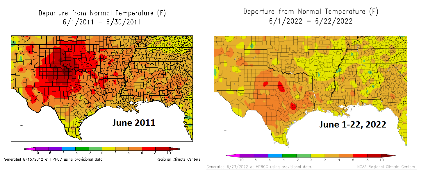
First off, while the drought is not as severe, 2022 has been hotter than 2011. The May 1-June 23 period checks in at an average (high + low, divided by two) of 83.4°, which smashes the record of 81.8° set in 2011 and again in 2018. The difference between 2011 and 2022 at this point is the extremeness of the heat. We are lagging 2011 in terms of warm temperature records set. But the consistency and persistence of stronger than normal heat is ridiculous. Our last below normal day was June 3rd. Depending on exactly how next week shapes up, we should see our hottest June on record this year.
May and June of 2011 featured some more extreme daytime heat across Texas, but this year is seeing more persistent heat, especially at night. (High Plains Regional Climate Center)
Interestingly, 2011 was hotter during the daytimes, but June 2022 is running almost 2 degrees above 2011 at night. And don’t even get me started on Galveston. The Island has set or tied *33* warm low temperature records just since May 1st. These are signals consistent with climate change, urban sprawl, and a very warm Gulf in our backyard.
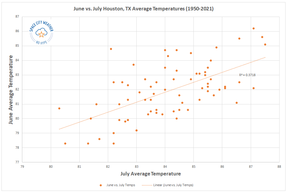
The second question about whether we can derive any insights for the rest of summer based on June’s outcome is a little trickier to answer. In general, what occurs in June has very little in common with July and August outcomes here in Houston. We can see this on a scatter plot, which simply compares the June average temperature on the y-axis with the July average temperature on the x-axis.
Since 1950, the correlation between June and July temperatures has been positive (hot Junes tend to favor hot Julys), but it’s pretty weak.
The chart above shows June vs. July in Houston. A June vs. August or July vs. August chart would not look too dissimilar. There’s definitely a loose correlation (hot Junes do favor hot Julys), but it’s pretty weak overall.
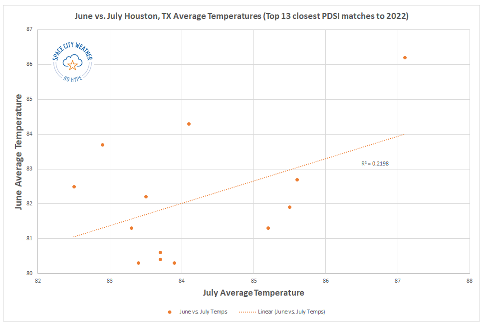
Now, what if we just look at some more significant drought summers. Drought would typically imply a stable pattern, much like we’ve seen this year. So I went back and looked at the Texas averaged Palmer Drought Severity Index (PDSI) by month back to 1950. I parsed out the March through May values and extrapolated out an approximate June 2022 value. In other words, I looked at a drought classification for all of Texas between March and June and found the 13 closest matches to 2022. Does that change the outcome? For July it does, significantly so. Remove 2011 from the sample, and there is virtually no correlation whatsoever.
There is very little correlation between June and July temperatures during years with dry March-June periods.
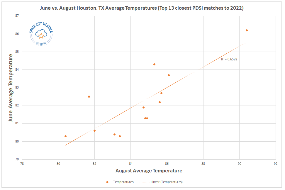
But what of August? That story appears a bit different.
There is some signal suggesting a hot June in a dry year boosts the odds of a hot August, though the sample size is a bit too small to say so definitively.
While there is a very nice correlation showing up here, a sample size of 13 summers feels just a little too small to say anything definitively. In fact, if we again remove the hottest outcome there, 2011, it cuts the R^2 value almost in half, implying a much weaker correlation.
What is the takeaway here? A hot June tells us very little about the subsequent July outcome other than it may also tend to be on the hotter side. A hot June in a drought year may also slightly favor a hot August outcome, but the sample size is too small to say anything with confidence. So, if you are hoping that the rest of summer is not as abnormally hot as June, you do have at least some hope here.
Drought update
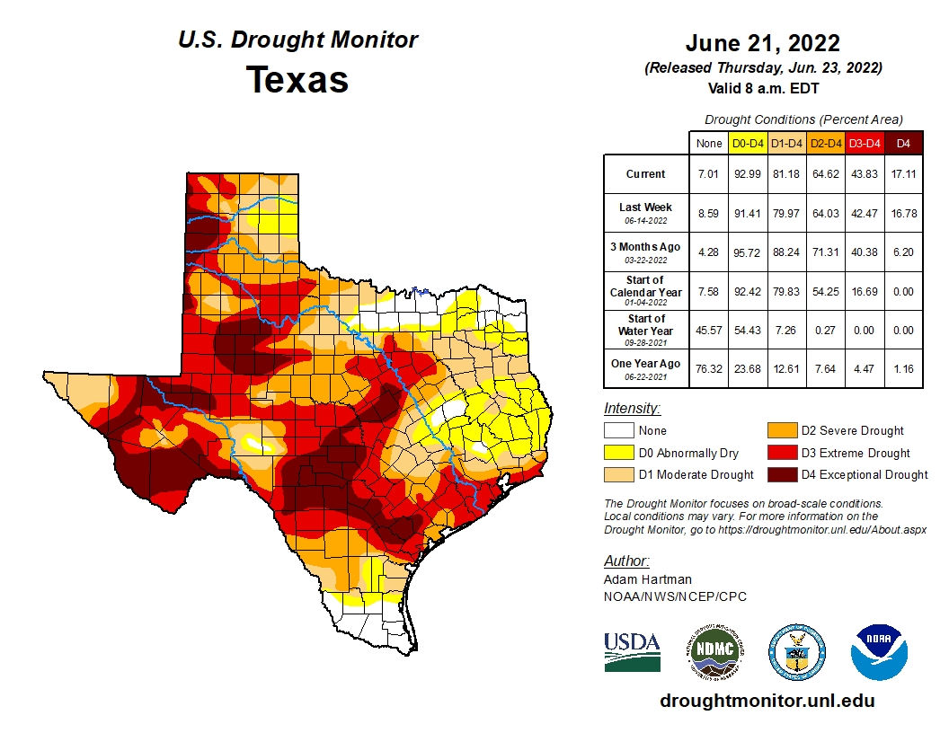
With new burn bans and water restrictions being issued daily across the region, a look at the drought map explains why.
Locally, we didn’t see much drought expansion this week, but the state as a whole continues to trend in the wrong direction. (US Drought Monitor)
The coverage of drought changed little across our area with yesterday’s update, and the southern half of the region remains in D3, or extreme drought conditions. But we continue to receive minimal relief. That may change next week, however.
Today through Sunday
Hot, hot, hot. Look for temperatures near 100° or hotter each afternoon with just the slightest chance for a shower or storm. Morning lows should be in the 70s inland and 80s near the bays and Gulf and perhaps in the Inner Loop. Heat index values should flirt with 105° each afternoon, so please use caution outdoors.
Next week: Ch-ch-ch-ch-changes
As the upper level high pressure system responsible for our scorching weekend escapes westward next week, this will open the Gulf up for daily thunderstorm chances. In any other summer, next week would not look overly impressive. Given how little rain we’ve had, however, just the chance at daily showers returning will likely make a big difference, at least temporarily.
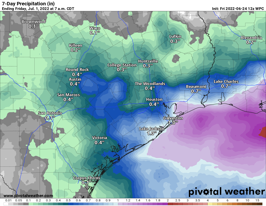
Rainfall between Monday and next Friday morning should average around a half-inch or a bit more south and east of Houston. Higher amounts are likely in spots, perhaps up to 1 to 3 inches. (Pivotal Weather)
I think the highest odds for more widespread coverage of showers will be on Tuesday, Wednesday, and perhaps Friday. We’re looking at something like 30 to 40 percent coverage of showers on average each day, with perhaps a couple days seeing 50 or 60 percent coverage. This means that you probably won’t see rain every day, but most of us will see at least some rain on a couple days. Let’s hope for around a half-inch of rain on average next week, with a few more frequently hit spots picking up 1 to 3 inches perhaps. It won’t end the drought, but it will definitely help.
As a result of the showers and clouds, look for high temperatures to back off into the mid-90s or low-90s most days. Lows should remain in the 70s.
Tropics
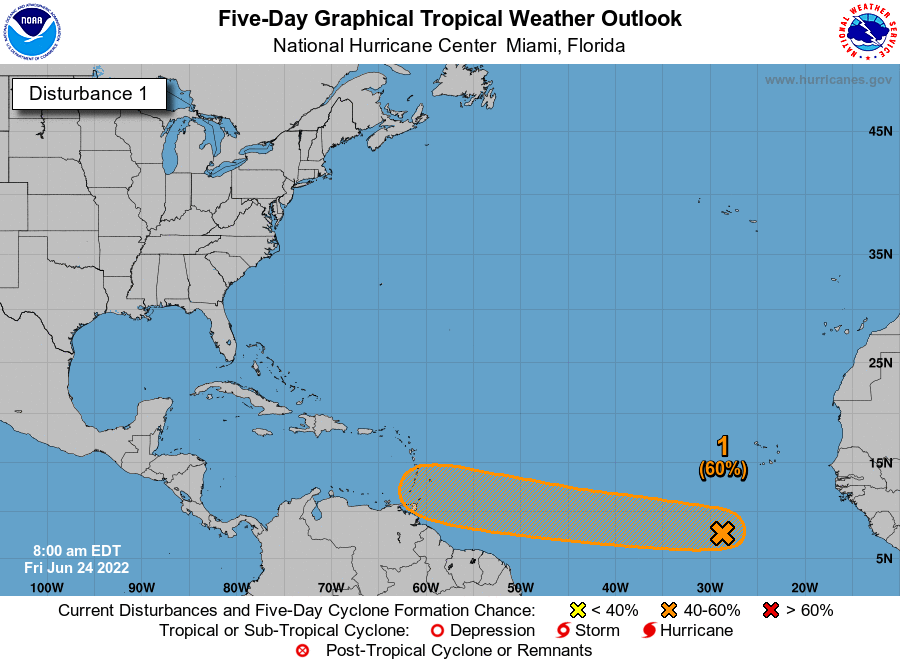
The National Hurricane Center has increased the odds of development of a disturbance in far eastern Atlantic to 60 percent over the next five days.
The odds of an Atlantic disturbance developing into a depression or tropical storm over the next 5 days have increased to 60 percent today. (NOAA)
This is rather far east for a system to develop at this point in the season, so it’s certainly noteworthy. However, from a Gulf Coast-centric perspective, this has a long, long way to go. Initially, my thought is that after next week’s rainy pattern, a hotter, drier pattern is going to attempt to again re-establish over Texas for the week of July 4th, which would be about the time this disturbance makes it into the vicinity of the Gulf. A stronger system would likely turn north before getting here, while a weaker system would likely be squashed by that ridge and forced into Mexico or Central America. So at this point, I don’t view it as something to worry about, but it’s worth checking back in on after the weekend.