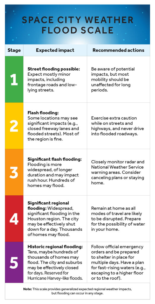
In brief: In today’s post we reveal the new design and content for our flood scale. We have made changes based on research conducted by the University of Houston. Although rain chances will increase later this week, we also anticipate no need to use the new flood scale any time soon.
Updated flood scale
This morning we are pleased to announce an update of our flood scale, which is intended to help guide expectations for people in the greater Houston region when it comes to the potential for flooding. We first introduced our flood scale in 2019, after Hurricane Harvey, and have used it dozens of times since then. But we really did not understand how people were using it.
Now, with the help of some researchers from the University of Houston, we do. A professor of Psychology, Steven Paul Woods, reached out to Matt a couple of years ago, and together they and one of his doctoral students, Natalie C. Ridgely, worked to perform a study of the scale and whether it was effective at communicating risk. Later this morning we will publish a summary of the study, and its results, written by Woods and Ridgely. (Here it is).
As a result of this study, we have made some changes in the structure of the scale to simplify it, and added recommended actions. Reliant provided a cleaner design. What thrills me the most is that this scale was created here in Houston, and improved by local researchers who care about this community just as much as we do. It is by Houston, for Houston.
Our new scale appears below:
Tuesday
Well, we won’t need the flood scale today. With high pressure firmly in place, Houston is going to have one of its hottest days of the year. With sunny skies, look for high temperatures to push into the upper 90s across most of the region away from the immediate coast. Some inland areas may reach 100 degrees. Winds will be very light, from the west mostly. Lows tonight will only drop into the upper 70s.
Wednesday
This will be another hot and mostly sunny day, with highs in the upper 90s. However there will be a couple of subtle differences. One is that dewpoints may drop into the mid-60s across the region. This is not “dry” in any great sense, but these dewpoints are lower than normal for this time of year. So humidity will be lower than we have been often experiencing this summer, especially for inland areas. There also will be a very slight chance of showers later on Wednesday afternoon or evening.
Thursday and Friday
Low pressure stretching across the Gulf will bring increased rain chances into the area for several days. On Thursday and Friday the likelihood of rain will be somewhere between 30 and 50 percent, with low-end accumulations for most. Depending on the timing of rain (if any) highs will vary between the low- and upper-90s, with partly to mostly sunny skies.
Saturday and Sunday
Better rain chances will arrive this weekend, with both days bringing about a 50 percent likelihood of showers. For now we don’t see too much of a risk for really heavy rainfall, and my expectation is that most locations will pick up between 0.25 and 0.5 inch of rain. Since this is summer and tropical rainfall is possible, we’ll be on the lookout for higher totals, but for now this looks more like a splash of rain rather than a deluge. Highs will generally be in the low- to mid-90s with partly sunny skies.
NOAA rain accumulation forecast for now through Sunday. (Weather Bell)
Next week
The first full week of August does not look to be excessively hot. Temperatures probably will be in the mid-90s for the most part, with a smattering of daily showers driven by the sea breeze. Beyond that, we shall have to see.
In brief: Today’s post discusses the historical depths of summer, which occur over the next two weeks. However, while we will see considerable heat the next couple of days, increasing rain chances should help to take the edge off summer heat through the weekend.
Depths of summer
Look, it can be really hot in Houston any time from April through October. And historically we have seen 100-degree weather as early as June 2, and as late as September 27. But the very warmest period of the year, based on climate statistics, comes from July 29 through August 12. This is when the region’s high temperature averages 96 degrees. By August 13, the average high drops to 95 degrees, and by the end of the month we’re down to 93 degrees. So we’re here, at the peak of summer in Houston.
And do you know what that means? If you squint, you can see fall in the distance.
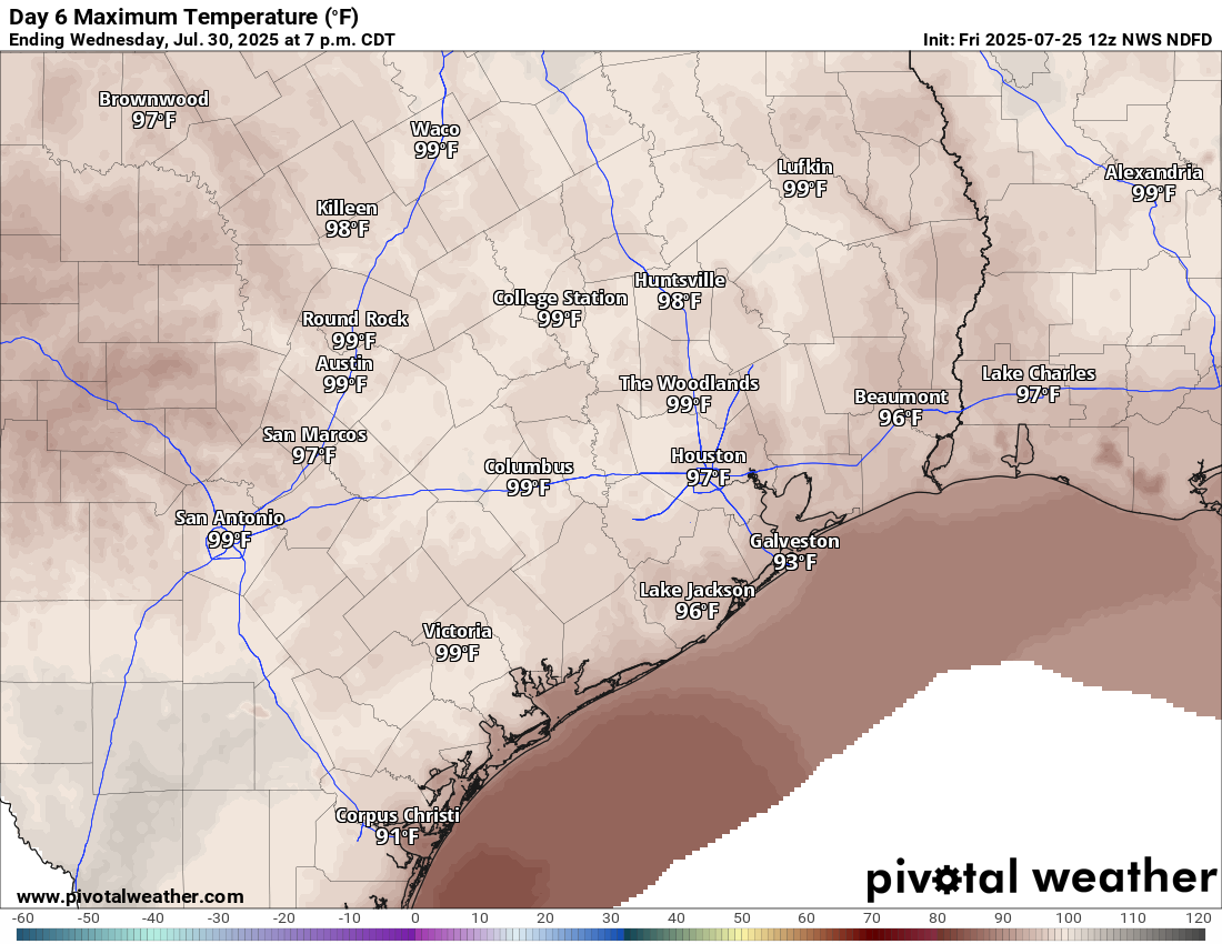
High temperatures on Tuesday may be the warmest of the week. (Weather Bell)
Monday
After several rounds of showers over the weekend, which included some flooding just east of downtown Houston, our weather will now quiet down for a few days as high pressure builds over the area. We will see that in the form of sunny skies today, with high temperatures in the upper 90s for inland areas, and lower 90s for coastal areas. With that said, I would not entirely rule out of a few scattered to isolated showers later this afternoon or evening along the sea breeze. Winds will be light. Lows tonight will be sultry, and in the mid-70s.
Tuesday
This will probably be the hottest day of the week, with sunny skies and high temperatures in the upper 90s for most of the region. However, dewpoints look to be slightly lower, so while the humidity will be high, it may not be oppressive. Rain chances are near zero. Expect another warm night in the mid-70s.
Wednesday
At this point I think high pressure will still largely influence our weather on Wednesday, so we can probably expect mostly sunny skies and highs mostly in the upper 90s. At the same time, we are going to see growing amounts of tropical moisture pooling to our east out over the Gulf, and this will bring higher rain chances during the second half of the week. So maybe we should splash in a low-end chance of a few showers.
Thursday and Friday
Skies will still probably be partly to mostly sunny to end the work week, with high temperatures generally in the mid-90s. However, as low pressure (the risk of this becoming a tropical depression or tropical system is near zero, so we’re not particularly concerned about that) drifts toward Texas across the Gulf, it will bring increased moisture levels into the coast. This will likely yield rain chances of about 30 to 50 percent for both days.
Most of the region should pick up some rain through the weekend. (Weather Bell)
Saturday and Sunday
We should remain in this pattern of elevated rain chances through the weekend, with a 50 percent likelihood of showers each day. At this point I don’t expect the weekend to be a total washout, and there still should be periods of sunshine on both days. But temperatures should be a couple of degrees cooler (some areas may top out in the lower 90s). Overall accumulations look fairly modest. Most of the area may see something on the order of 0.5 inch of rain, but there probably will be higher bullseyes. All in all, for the peak of summer, it won’t be terrible as Houston moves into August.
Next week
I think we will see a continued chance of showers on Monday and perhaps Tuesday before things high pressure asserts a little more control next week. However, at this point I think we’re likely to remain the 90s rather than pushing up into the 100s.
Tropics
Things look very quiet out there for the next week or so, and quite possibly beyond. This is a great position to be in as we edge toward the month of August. Longtime residents will know that the next two months are, traditionally, “go time” for Texas and the tropics. So we will be watching things very closely.
In brief: Periods of rain and scattered thunderstorms will be with Houston today and tomorrow as a disturbance moves in from the Gulf. Then, we will get another round of heat heading into next week, peaking on Wednesday or Thursday.
Today
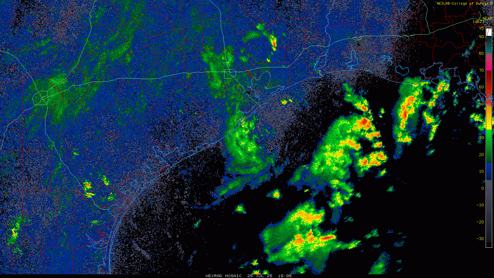
The tropical disturbance with 10 percent development odds that we’ve been discussing all week is on final approach to the Texas coast. The NHC pegs it just south of Vermilion Bay in Louisiana. On radar, we’ve clearly got a few showers across the area. There is a more robust area of rain closer to the disturbance itself that’s moving westward over the Gulf.
Radar loop ending around 7 AM. (College of DuPage)
As the day goes on, look for that area of rain to move toward Galveston and/or Freeport. Inland areas will see quick moving downpours at times. Once the disturbance comes ashore tonight, there could be periodic downpours and even some thunder. Some areas will see little to no rainfall. Other places could pick up a quick inch or so in heavier downpours. I do think coastal areas may see a steadier rain later today, and thus they could see up to 2 inches or so of rain before all is said and done.
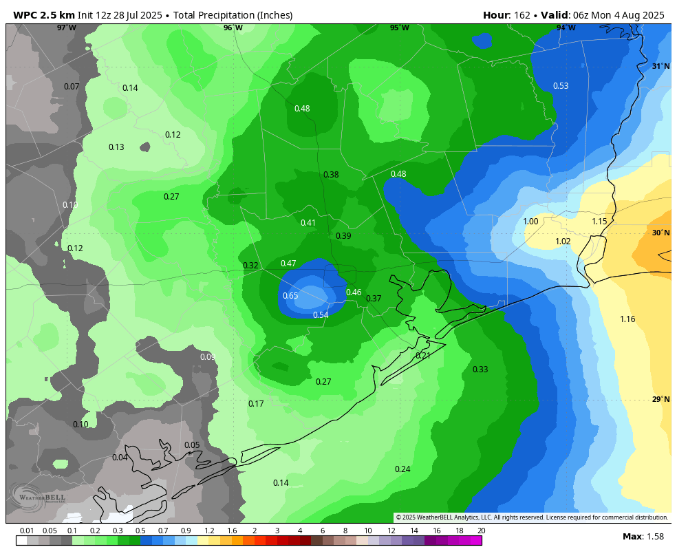
Total rainfall through Sunday evening. Consider the above an “average,” as some areas will see less rain and one or two spots may see a bit more. (Pivotal Weather)
High temperatures this afternoon will struggle and may not even reach 90 degrees in many spots. Look for upper-80s to low-90s (if the sun gets out) and a bit more humidity than we’ve had this week.
Saturday and Sunday
This tropical disturbance is not slowing down for anyone. By tomorrow afternoon, the fingerprint of the disturbance should be past I-35 and into West Texas. We will still see scattered thunderstorms across the area, with an increase in coverage as temperatures warm up tomorrow.
On Sunday, the chance of rain drops even a bit more, but again not to zero. While Saturday will probably top off in the low-90s, Sunday could be in the low to mid-90s.
Next week
So what’s next? First, we’re going to get a surge in heat once more. Houston should peak in the mid-90s on Monday with a chance of a storm, mid to upper-90s on Tuesday, and upper-90s to near 100 degrees on Wednesday and perhaps Thursday.
Forecast high temperatures for next Wednesday show nearly 100 degrees again in spots. (Pivotal Weather)
After Thursday, it almost looks like yet another Gulf disturbance may enter the picture, though this one could be even a bit farther north (possibly over land) than the current one. No real development risk by any means, but we’ll see if this can’t help enhance shower and thunderstorm chances and lower our temperatures to close out next week.
In brief: The Gulf tropical disturbance is unlikely to develop, but it will bring some rain to the area tomorrow and Saturday. We have one more shot at 100 today before a brief break. More 100 chances return next week. Today we also dive into Bush Airport and talk about why it seemed to be such an outlier on Tuesday.
First, the tropics
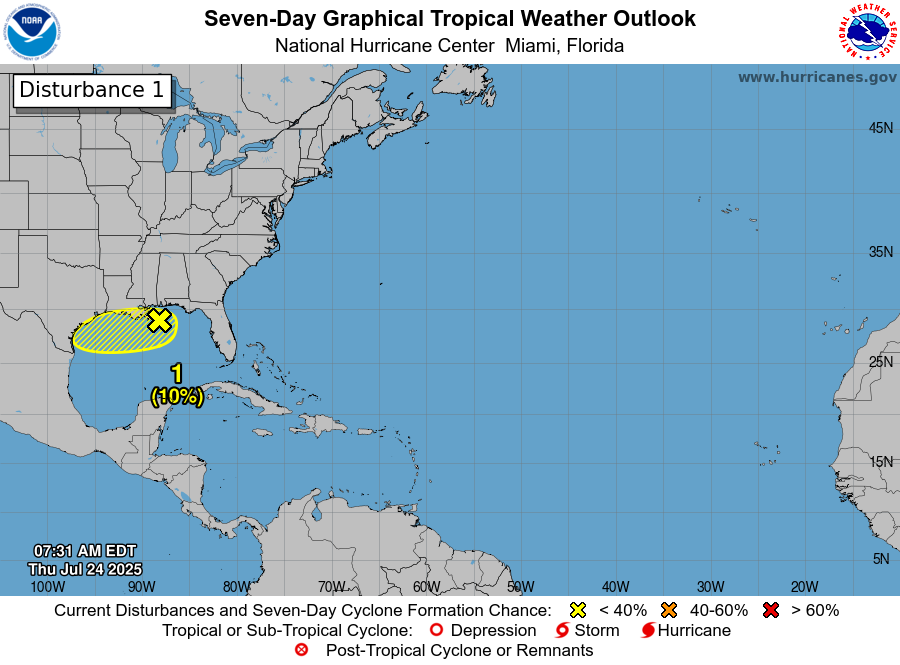
Let’s start quickly this morning with the tropics and on this disturbance we have moving across the Gulf today and into our region tomorrow. There continues to be little to no chance of development with this. For Greater Houston, that means an increase in rain chances tomorrow and Saturday. And even that should be manageable.
Odds of development are 10% or less with this disturbance in the Gulf. (NOAA NHC)
Now, how much rain? Well, Friday will be interesting. It could go one of two ways I think. The first way? The disturbance approaches Texas and we get a solid rain shield offshore, so coastal areas see a fair bit of rain in the morning, with inland areas seeing just a few scattered afternoon thunderstorms. Alternatively, we see a small bit of rain in the morning at the coast and then more numerous showers and afternoon thunderstorms moving southeast to northwest across the region. I am leaning heavily toward the coastal rain outcome, where inland areas see some scattered storms but nothing too widespread. This means folks in Galveston could easily see a couple inches of rain, and more numerous showers and storms may push across Brazoria, Galveston, and Chambers Counties.
On Saturday, we’ll probably see a repeat, except I think storms could be more numerous across the entire region. As we’ve been saying, it should not be a total washout, but you’ll want to have some rain plans in place on both Friday and Saturday if you’re planning outdoor activities.
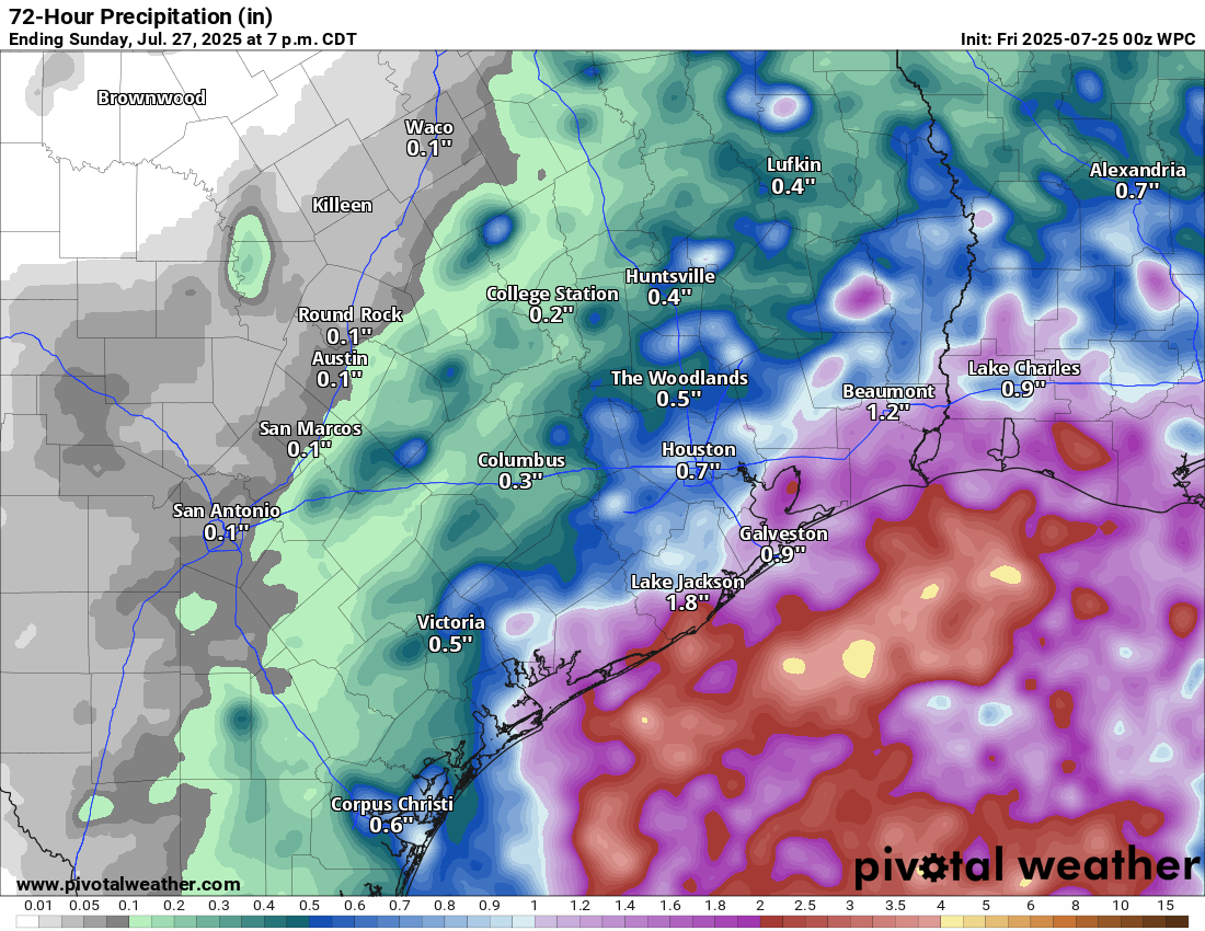
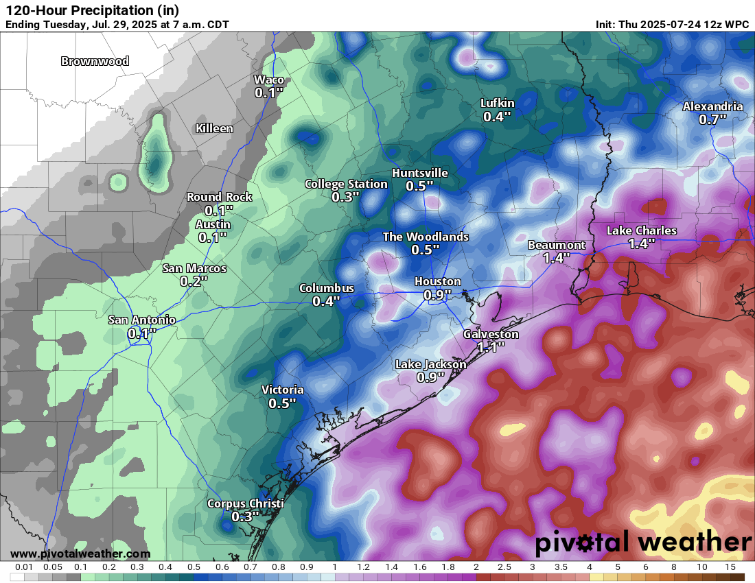
Average forecast rain totals between now and Tuesday AM. (Pivotal Weather)
Rain totals will be on the order of probably 1 to 2 inches at the coast and a gradual trailing off of rain inland down to about a half-inch to inch inside the 610 Loop and less than that farther inland on average. Some areas may see little to no rain. Other isolated pockets, especially south and east of Houston could see 3 to 4 inches of rain.
Next, the heat
We hit 99 degrees yesterday, and we will make another run for 99 or 100 today probably. With clouds and showers around, Friday and Saturday should be substantially less hot. But look for the heat to return Sunday or Monday, and we will be making another run at 100 degrees by Tuesday or Wednesday.
Is the IAH thermometer rigged?
The fun thing about weather is that no matter where you live, if something looks the slightest bit suspicious, people start weighing in with lukewarm and hot takes about why there’s something wrong with a temperature sensor, someone has an agenda and is purposefully fudging data, and on and on. One of my favorites is when Washington, DC gets snow, virtually the entire city gets mad at whoever measures the snow at Reagan Airport because it is obviously too low. In Philadelphia, you get the opposite, the snow totals almost always get yelled at by people for being inflated.
Well, we’ve got ourselves a fun game of this happening in Houston now. On Tuesday, when IAH hit 100 degrees, many people were convinced it made no sense.
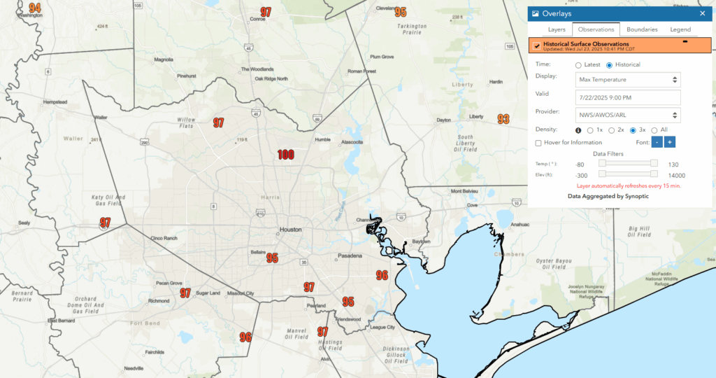
Tuesday’s actual high temperatures from primary weather stations across the area. (NOAA)
And, honestly, looking at that map above, I get it. IAH does stand out. Out of an abundance of caution, the NWS sent their electronics technician out to look at the thermometer at IAH. It was fine. It was reading where it should have been, and there have not been any recent changes near the thermometer. Turns out, it’s just hot at IAH. If you look at the high temperatures on Tuesday from a number of additional weather stations, filtered for most of the clearly bogus values (50s, 110s), you’ll see multiple spots hit 100 degrees.
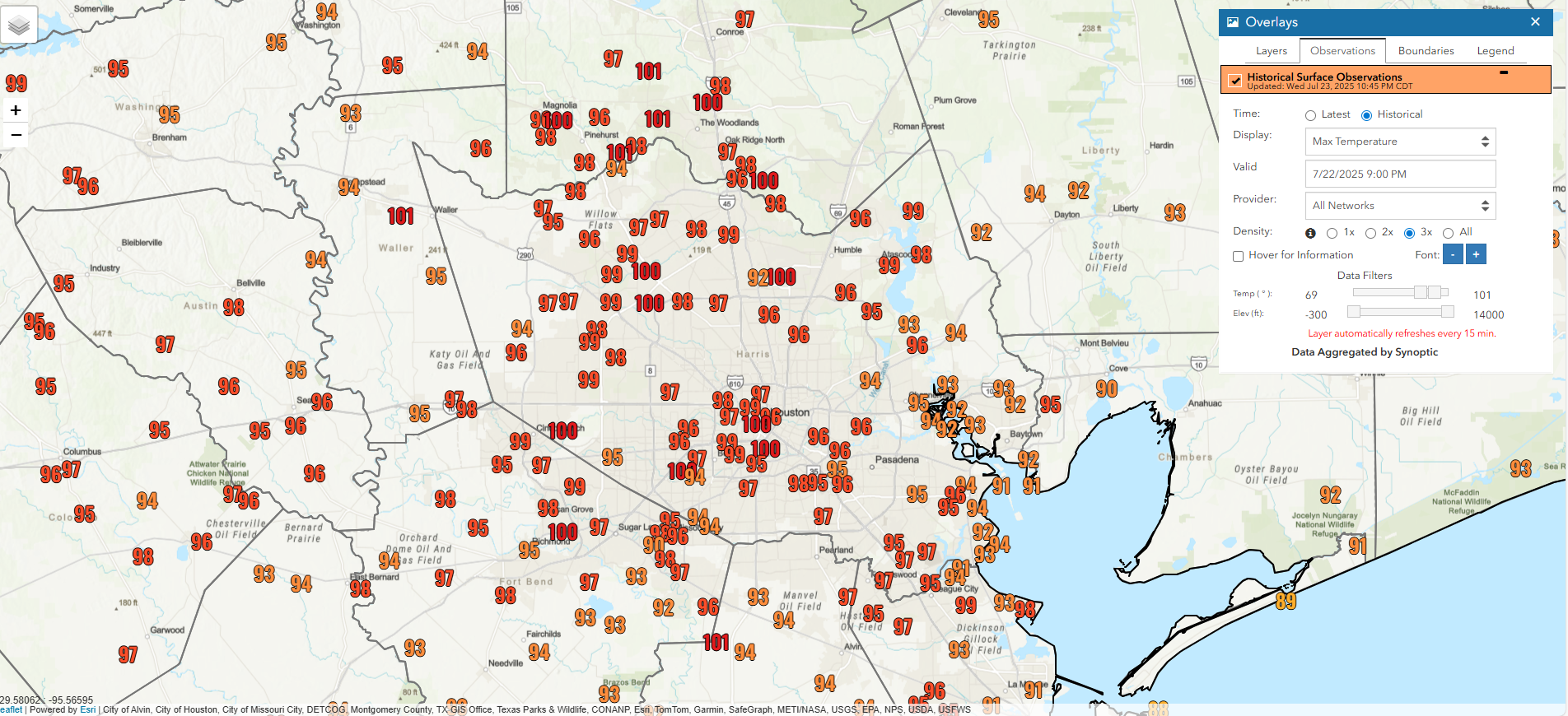
There was quite a variation in high temperatures on Tuesday across the area when you really drill into things. (NOAA)
I’m not going to say that each of these weather sensors is sited perfectly or calibrated perfectly, but based on what I saw from sensors that I trust on Tuesday, I would have expected IAH to top off around 98-99 degrees. So, 100 doesn’t exactly shock me. But it’s definitely at the top end of temps for our area.
So, what is the deal with IAH, and can we trust it as a long-term indicator of our climate? It’s a complex and complicated question to answer. In most cities, historical data did move from essentially the center of town “back in the day” to airports. Official readings are now almost always taken at airports, where no one actually lives, of course.
A few places are unique or have complexities: Think Central Park in New York City; not an airport and a good, long historical data record. In Austin, you get to choose from Bergstrom Airport or Camp Mabry, two locations that can be very, very different during certain events. Downtown Los Angeles has also had a checkered history, with a weather station that has now moved 8 times. The linked article is from 2014, when USC housed the official Downtown L.A. sensor. It now sits on the south side of Dodger Stadium. The next time I visit SoCal, I intend to wear an Altuve jersey, go stand by it, and boo it. When stations like this move, there’s a process called “threading” that occurs. This process is by no means perfect, but it does a fairly good job of ensuring that station discontinuities are accounted for and the extremes we’re measuring against historically are as unified and realistic as possible.
Is IAH a reliable indicator of Houston’s weather history? Ten people will have ten opinions on this, but the reality is that it’s not really any worse than any other spot in the area. Houston is constantly evolving, growing, and changing. IAH isn’t perfect, but I think the important takeaway would be that there’s a difference between being representative of where people live versus being representative of reality at a given point. IAH isn’t a reliable indicator of every neighborhood’s weather history in Houston. But it is reliable as a location for our climatology today. In other words, compare IAH to IAH, not IAH to elsewhere. IAH hit 100 on Tuesday. Compared to previous records at IAH, it was one degree shy of a record high. That doesn’t mean that Sunnyside was 1 degree shy of a record. Or Sheldon was 1 degree shy of a record. IAH was. And since our official records are kept there, “Houston” was. You could make a similar argument about DFW Airport, which keeps Dallas’s official records or O’Hare in Chicago or Logan Airport in Boston.
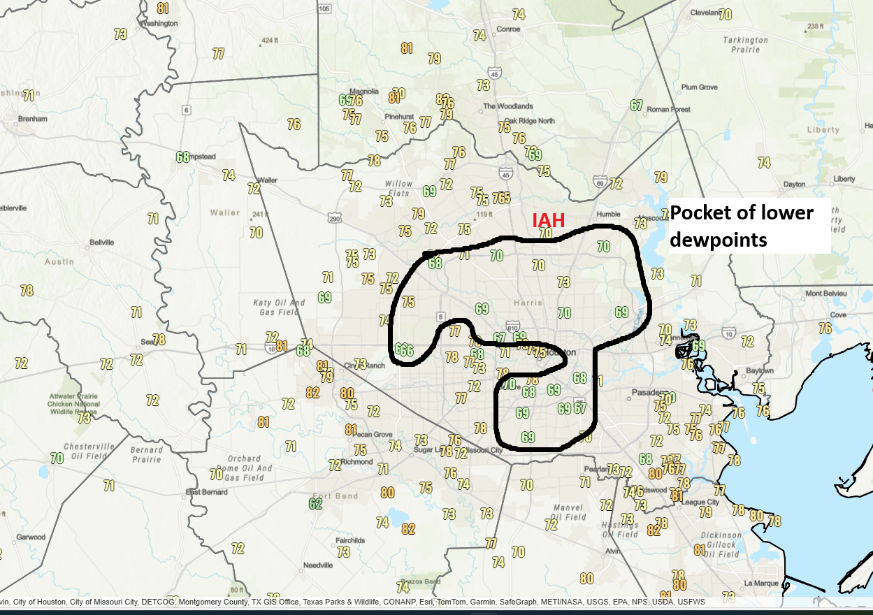
Going back to the 100 on Tuesday, one of the key reasons for it may have been the lower humidity we saw that bubbled up in a pocket of the city. We can assess that with dewpoint values, as seen below. Also, IAH had 42% relative humidity at 3 PM, right around when it hit 100 degrees, which was one of the lowest relative humidity values in the city at that time.
The 3 PM Tuesday dewpoint map shows a bubble of lower humidity focused near and just south of IAH. (NOAA)
Drier air heats up more efficiently than more humid air, and when you have an air mass this hot, it doesn’t take a massive change in humidity to lead to a somewhat outsized change in temperature. Bottom line? It seems that a localized pocket of low humidity impacted the area near the airport. When combined with the already generally hot location of IAH, it led to a bump to 100 degrees on Tuesday, when most other locations were more like 96 to 98 degrees.
Does this settle the debate? Never. Everyone will still have opinions on this. Weather is a bit like sports in that regard, I guess. But when thinking of IAH, it’s a microcosm of all the things influencing our history here: Urban heat island, sprawl, a warming Gulf, and climate change all playing roles. But we wanted to share some of the plausible reasons why it happened, as well as add some color on IAH. Not perfect, but it’s what we’ve got.