In brief: A short post today, with not much to say about the hot and sunny weather expected to persist through the holiday weekend. Mainly, we want to wish you a Happy Fourth of July, and the country an amazing 250th birthday.
Overall pattern
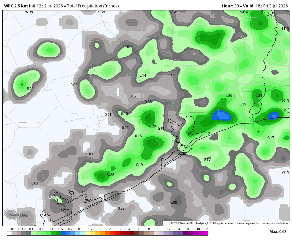
A decent chunk of the Houston area saw precipitation on Thursday, especially areas along and east of I-45. Friendswood was the big winner, with some areas picking up in excess of 2 inches. Atmospheric moisture levels have dropped back a bit, and with no triggers we are going to move back into a pattern of isolated showers and thunderstorms this weekend. Expect chances to be about 10 percent daily, with our region on the periphery of a potent high pressure system located over the eastern United States.
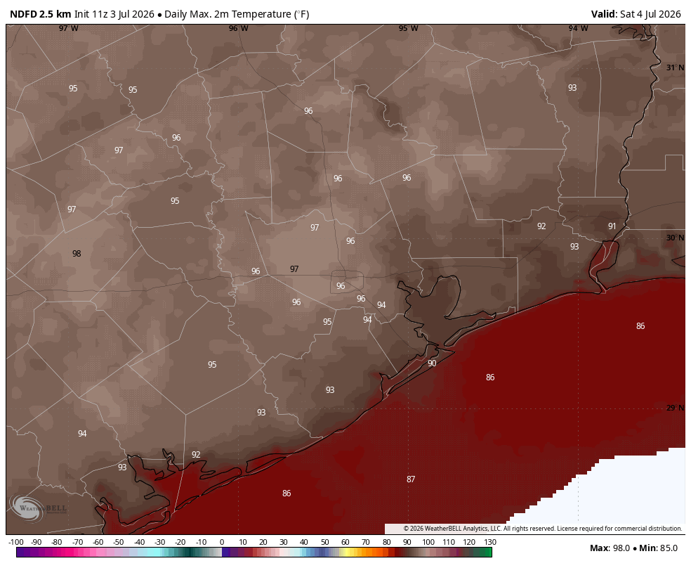
High temperatures for the Fourth of July in Houston. (Weather Bell)
Friday, Saturday, and Sunday
These will be mostly sunny days with high temperatures generally in the mid- to upper 90s across the Houston region. Only coastal areas will be a few degrees cooler. Rain chances, as noted above, are probably around 10 percent, with the slightest chance of a sea breeze shower. Winds will generally be light, only picking up a little bit during the afternoon hours, at 10 to 15 mph. Lows will generally fall into the upper 70s. If you’re in town from Canada for the World Cup match on Saturday, rest assured that the football stadium has extremely good air conditioning. Moroccans may feel a little more at home.
Early next week
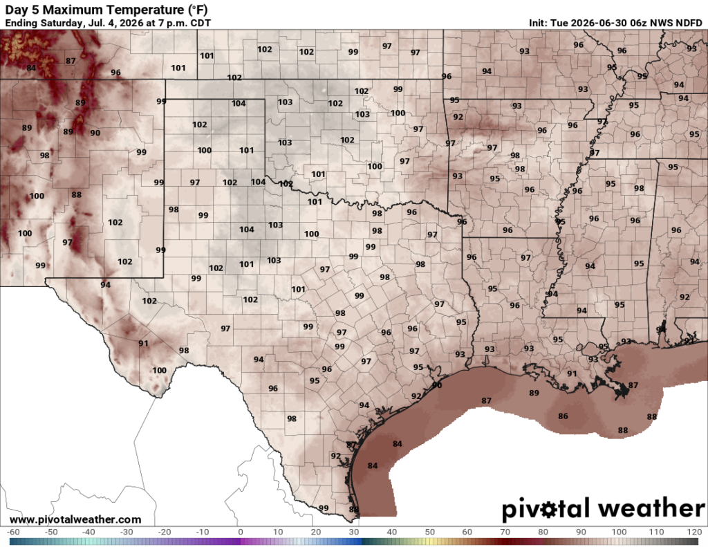
We may see some slightly better rain chances to start next week, with perhaps a 20 percent or so likelihood on Monday and Tuesday. But the overall, prevailing pattern should remain more or less the same with hot days and mostly sunny skies.
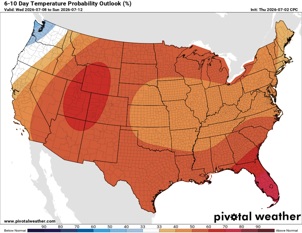
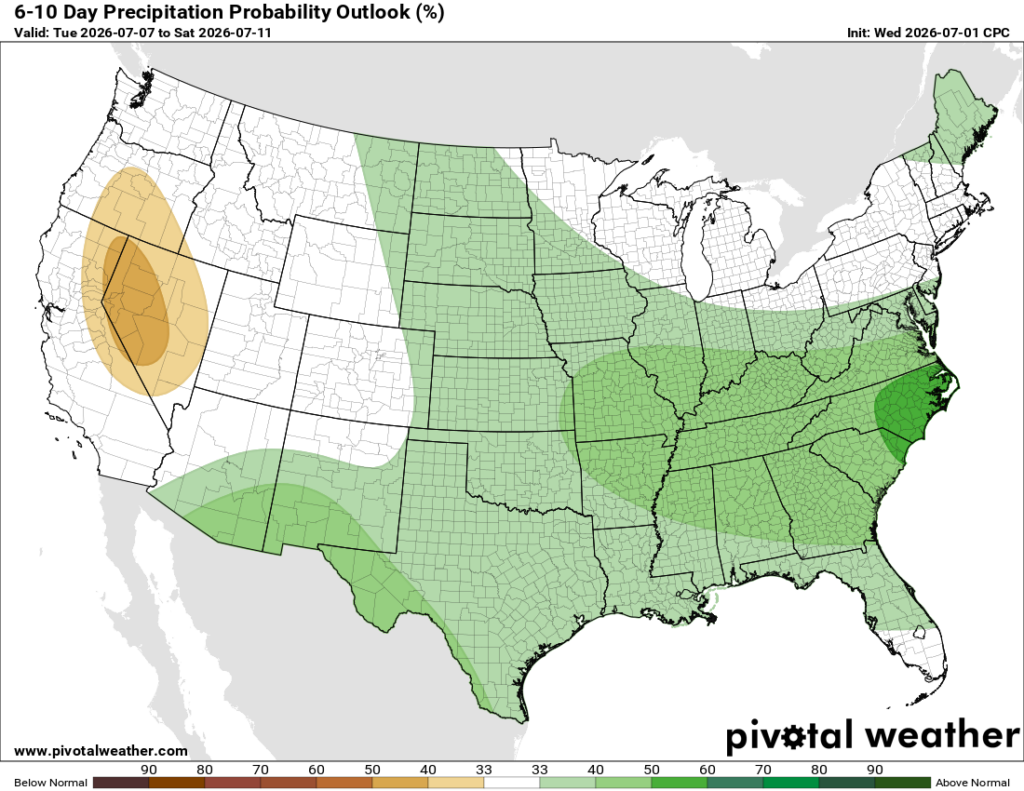
Hotter than normal conditions continue for much of next week across the United States, including Texas. (Pivotal Weather)
Later next week
There’s probably not a whole lot of change later next week. Best case scenario is we end up in a pattern where sea breeze showers are possible (i.e 30 percent daily). Probably the likelihood of rain will be lower. Our high temperatures will continue to sizzle in the mid- to upper-90s, a few degrees above normal for this time of year.
In brief: In today’s post we have a lot going on: A little World Cup talk, an official forecast for the Fourth of July holiday, and shockingly some fairly healthy rain chances for today.
America turning 250 years old
Good morning to everyone except Raphael Claus, the Brazilian soccer referee who issued a red card to US starting striker Folarin Balogun on Thursday night. If you’re like me, you’ve been enjoying the World Cup games this year, which have been spread across North American venues, including Houston.
Last night the environment at Pitch 25 near downtown was electric for the US match against Bosnia and Herzegovina. Balogun scored a goal, but then received a questionable red card from Claus and was ejected from the game. The Americans held on, despite being down one player. Exciting!
Anyway, the US men’s team has advanced to the round of 16, playing against Belgium on Monday evening at 7 pm CT. It has been enjoyable to be swept up by the sport, and wonderful to have so many foreign visitors for the games in Houston. We have one final match on Saturday, between Canada and Morocco at Noon.
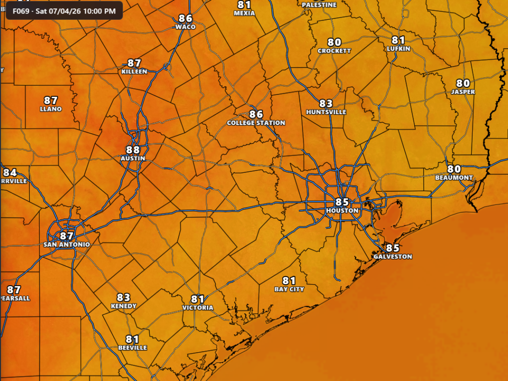
Air temperature forecast for 10 pm CT on Saturday, approximately the hour of fireworks. (Weather Front)
The World Cup comes amid the 250th anniversary of the adoption of the Declaration of Independence. We will celebrate this founding document, which asserts our right to self-governance, and more broadly represents freedom and democracy, on Saturday. Our confidence in the weather forecast for the Fourth of July is high: We are going to see a sunny and hot day, with high temperatures ranging from the mid- to upper-90s across the region, except for the immediate coast. The air will be humid. And conditions optimal for fireworks—as long as you’re willing to sweat a little.
Also be sure to check out a few words from our sponsor, Reliant, at the end of today’s post. As our temperature soars upward for the next couple of months they recognize that energy affordability is a serious issue for many of us. They have some tips to help control electricity costs. Reliant has not been with us since the founding of Space City Weather in October 2015, but they came on board soon after. If we had been founded in 1776 like the United States, it would be like Reliant came aboard in 1810. So they’ve been with us for a long time, helping to keep the lights on here, and we appreciate that.
Rain accumulation today could look something like this. (Weather Bell)
Thursday
Alright, before we get to sultry and sunny conditions this weekend, we do have a decent chance of some showers and thunderstorms today. Do not set your expectations overly high, but I do think about 40 or 50 percent of the region will see some showers later today with peak heating. Rainfall amounts will vary widely, with some areas seeing a smattering of rain while a few locations may pick up as much as an inch. Some showers may briefly pulse up into thunderstorms. This is our best chance of rain in more than 10 days. Highs likely will reach the low- to mid-90s, depending on local rainfall conditions this afternoon. Winds will generally be light. Lows tonight will drop into the upper 70s.
Friday, Saturday, and Sunday
The holiday weekend will bring lots of sunshine into the Houston area, and likely our hottest weather of the year so far. Expect highs in the mid-90s on Friday, likely peaking in the upper 90s on Saturday, and getting close to that on Sunday. Rain chances will be about 10 percent on Friday and Saturday, but may bump up slightly to 20 percent by Sunday. The air will be fairly humid, as is usual for early July. Please remember sunscreen for daytime activities, and you’ll probably want some bug spray for fireworks in all but the most urban of settings.
We may see some improvement in rain chances next week. (Pivotal Weather)
Next week
There’s a couple of different paths our weather could go down next week, and I don’t have the highest of confidence about what will happen yet. My best guess is that we’ll see a few more clouds, some better rain chances, and perhaps a slight moderation in temperatures. But there remains the possibility of ongoing sunny, and largely rain-free days. Not helpful, I realize.
A message from our partner, Reliant
Whether Texans are firing up the grill at home or hitting the road for a holiday escape, the long July 4th weekend presents plenty of opportunities to use energy more efficiently. Reliant is sharing simple tips for anyone to save money and cut back on energy use while still staying cool and enjoying the holiday.
Traveling for the holiday weekend:
Follow the “four-by-four” principle instead of turning off your HVAC system completely. Set your thermostat four degrees higher when you’re away from home for more than four hours to reduce electricity usage while staying efficient upon your return home.
Leverage smart thermostats and smart home devices, whichare powerful tools to manage energy usage while away. You can adjust settings remotely, as well as pre-cool the house before you return.
Close blinds and shades to prevent heat buildup and get the most out of the cool air coming from the AC.
Turn off or remove anything plugged into an outlet that doesn’t need to run while you’re away, like chargers and electronics with lighted displays. Even small appliances draw power in standby mode, which can add up over time.
Reduce your water heater temperature. For shorter trips, keeping your water heater’s temperature at or above 120-140°F helps prevent bacterial growth while maintaining efficiency.
Enjoying the long weekend from home:
Grill outdoors. Cooking indoors raises the heat, requiring the AC to use more electricity.
Use heat-producing appliances like the dryer, dishwasher, or oven after sundown instead of during the hottest times of day.
Avoid running your pool pump all day by using an automatic timer.
Set your ceiling fan to rotate counterclockwise to create a wind chill effect. Also turn off fans when you leave the room.
More money-saving tips from Reliant can be found here.
In brief: In today’s post we look back at the first six months of the year, and review the most impactful weather event during that time. We also talk about some increased rain chances for Thursday, and a hot and sunny holiday weekend.
Six months into 2026
As of this morning, this year is now half over. In terms of weather it has been a fairly unspectacular start to 2026 in the greater Houston region, but given the extremes possible here, boring is usually good. The most notable event this year was an Arctic front in January, which followed a very warm start to the year (remember when five of the first nine days of the new year reached 80 degrees, or higher?)
The Arctic front brought widespread low temperatures in the 20 to 25 degree range, and the forecast was complicated by a large amount of precipitation falling just as it moved into the region. Ultimately Houston escaped the worst of this freezing rain. While other parts of the state such as Dallas and Austin were iced and snowed in for days, our region was relatively unimpacted in terms of mobility.
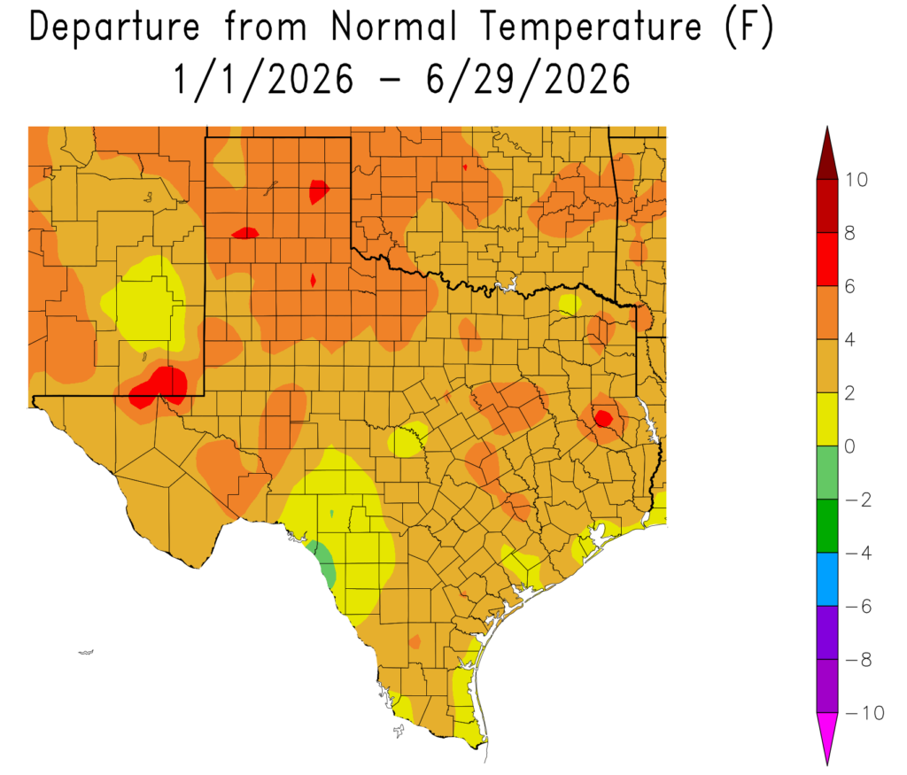
Departure from normal temperatures through the first half of 2026. (HPRCC)
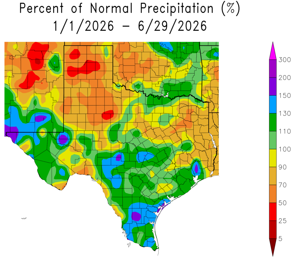
Overall with regard to temperatures, this year has seen above normal conditions on average. The greater Houston region has generally recorded an average temperature of 1 to 4 degrees above normal. With regard to precipitation, a wet end to spring and start of summer helped pull the region out of a drought. Although parts of Montgomery County remain below normal for this year, most of the Houston region has received 100 to 130 percent of normal rainfall levels. Some parts of Chambers County have received nearly twice as much as normal.
Percent of normal precipitation for the first half of 2026. (HPRCC)
What will the second half of the year bring? It’s always a mixed bag in Houston. We get our hottest temperatures of the year from mid-July into early September, and our best chances for hurricane disasters. But then, if we can get past that period, fall beckons and that is a great time of year for our region. So as ever, with our weather, we will have to see what happens.
Wednesday
This day will see a continuation of our recent weather pattern, with high temperatures generally in the low- to mid-90s across the region, along with mostly sunny skies. Like we saw on Tuesday, there will probably be some isolated showers and possibly thunderstorms dotted across the region this afternoon. But your overall rain chances are probably on the order of 20 percent, and in most cases the showers should pass quickly. Humidity remains high (of course!) and lows tonight will likely fall into the upper 70s.
Thursday
We’ll see a little more atmospheric moisture on Thursday, and with high pressure now having moved away to the northeast, I think there will be a slightly better chance of rain, probably something like 30 to 50 percent for the Houston area. Of course any showers will be hit or miss, with some locations getting no rainfall at all, and perhaps a few isolated areas seeing as much as 1 inch. Highs should still reach the low- to mid-90s.
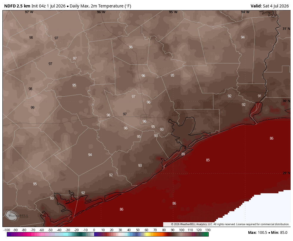
Expect a hot Fourth of July. (Weather Bell)
Fourth of July holiday weekend
For the most part sunshine and heat will prevail this weekend. Expect daily highs in the mid- to possibly upper-90s for most of Houston, with only coastal areas remaining a few degrees cooler. Winds will also be fairly light. We’ll see something like 10 percent rain chances on Friday and Saturday, and possibly up to 20 percent on Sunday. So again, overall odds are low, but we cannot rule out some passing showers during the afternoon hours. Conditions for fireworks look ideal, if hot.
Next week
It is difficult to say too much with confidence about our weather next week, but we may enter a pattern in which we see a few more clouds during the afternoon hours. This may shave a degree or two off of high temperatures and introduce some slightly better rain chances to start the week. Whether this weather lasts all week is something we’ll have to see about.
In brief: Some low-end rain chances will now return to the forecast for the rest of the week, but don’t have high expectations. We continue to see warm and humid weather, with the Fourth looking to be in the mid-90s for most of us.
High pressure departing, sort of
After more than a week of residing over Texas, the high pressure system that has brought us sunny and hot weather is moving off to the northeast. (It will bring rather hot temperatures to the East Coast over the holiday weekend. Forecast highs in Washington DC on the Fourth of July, for example, are in the low 100s). Anyway, for us, it means a tiny bit of variation in the forecast for the next 10 days.
Texas will have a hot Fourth of July. (Pivotal Weather)
For starters, rain is back on the menu. Now don’t set your expectations too high, but we will start to see more atmospheric moisture moving in from the Gulf this week, and there won’t be as much sinking air over land to completely shut down showers. Daily rain chances are likely on the order of 20 percent this week, rising to perhaps 30 or 40 percent on Thursday. Overall accumulations still look to be pretty slight, so any showers that do develop should pass through pretty quickly.
As for temperatures, there won’t be too much change here. However, I could see a scenario in which our highs push a degree or two higher over the weekend. So for the Fourth of July we are looking at a rather warm day in the mid-90s for much of the region.
Tuesday
We are starting this morning in the upper 70s, with light winds from the southeast. As we’ve seen for awhile now, with mostly sunny skies this afternoon, expect highs across the region to rise into the low- to mid-90s. Winds will pick up this afternoon, gusting to perhaps 20 mph or so. We have the possibility of a few, brief showers. Low temperatures tonight should briefly fall into the upper 70s. The Saharan dust we saw peaking on Monday (with a slightly purple-ish sky) is largely gone now.
Wednesday, Thursday, and Friday
These days look to be more or less similar temperature-wise, with highs in the low- to mid-90s and mostly sunny skies. It is possible that slightly increased moisture levels on Thursday bump rain chances up a little bit higher (to like 30 or 40 percent) but I want to see a little more data before I become confident in that. Mostly, summer continues unabated however.
Fourth of July weekend
Mostly sunny skies will prevail over the holiday weekend, with highs likely in the mid-90s for most locations, and the possibility for some upper-90s for further inland areas. Look, it’s going to be early July in Texas, with plenty of sunshine, so you know it’s going to be hot and fairly humid. Could we see a few stray showers during the afternoon along the sea breeze? Sure. Are they likely for most areas? No. Fireworks viewing should be fine, if sultry. Don’t forget the bug spray.
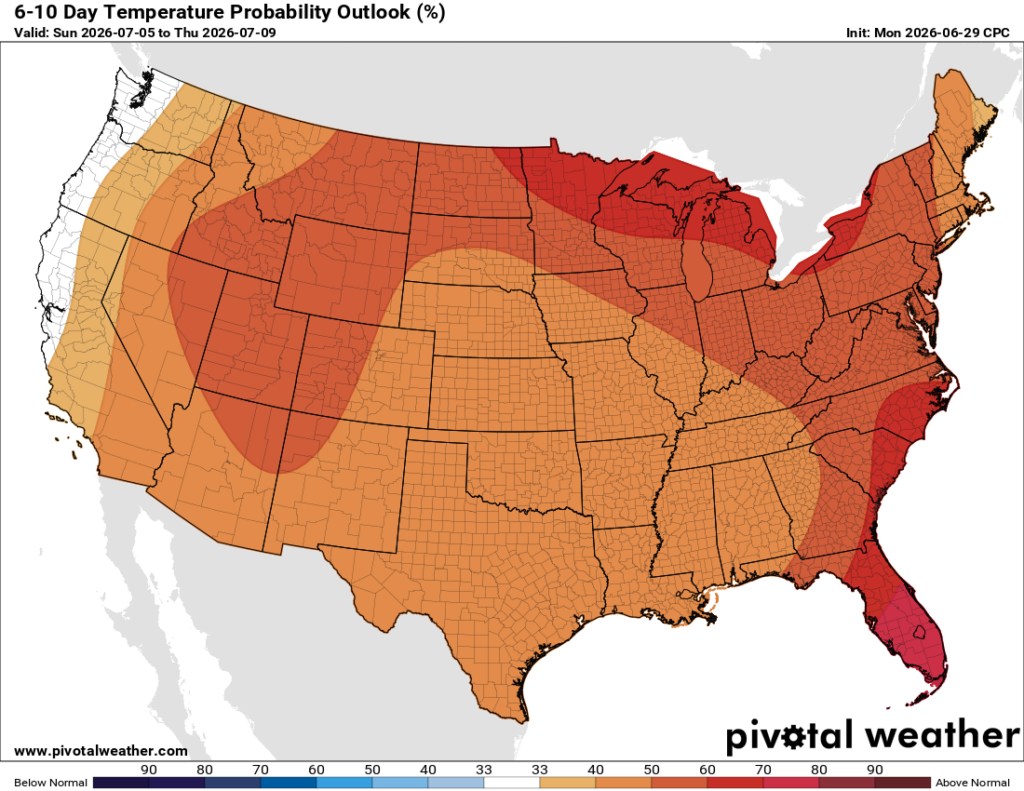
Warmer than usual conditions will occur for much of the United States next week. (Pivotal Weather)
Next week
At this point I expect next week to be fairly similar to this week’s conditions: Hot, some low-end rain chances, and plenty humid. It will be better than two years ago, when Hurricane Beryl was barreling down on Houston.