In brief: This post discusses our relatively mild start to the month of August, which is a nice change from some of our recent summers. And really the forecast does not offer much variability, with highs likely in the low- to mid-90s for awhile with a splash of daily rain chances.
It could be worse
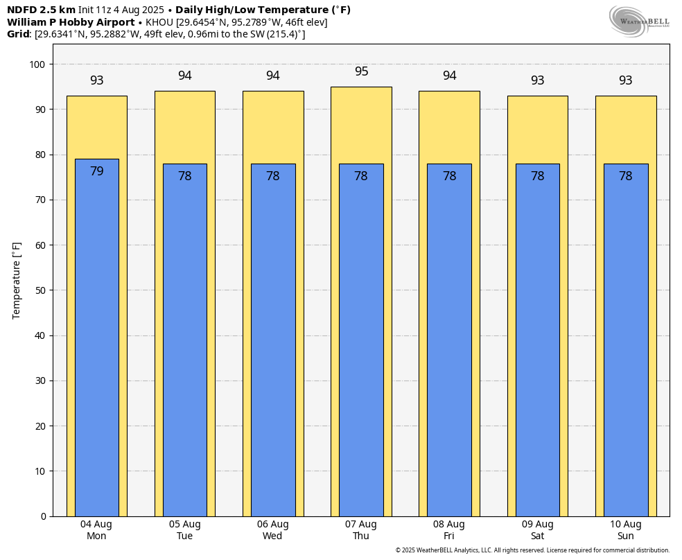
The average high temperature during the sizzling first week of August, 2023, was 102 degrees Fahrenheit. (I felt a shudder as I wrote that). Last year it was 97.5 degrees. This year, so far, we’re running at 93.8 degrees. This is not exceptionally cool, but it is a little bit below the normal high for this time of year (96 degrees). As Matt has noted the moderate daytime temperatures we’ve been seeing this summer have been offset by extremely warm nights, but nevertheless it sure feels nice to go through what is typically the hottest time of the year and have days that aren’t at or near record high temperatures.
And I don’t want to jinx anything, but it looks like we should remain solidly in the low- to mid-90s through at least the middle of the month as high pressure appears unlikely to build directly over the region anytime soon.
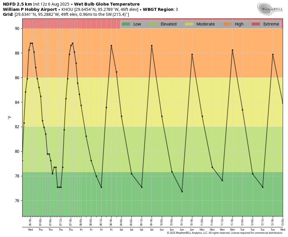
Wet bulb globe temperatures indicate “high” heat for the coming week, but this is typical for August. (Weather Bell)
Wednesday
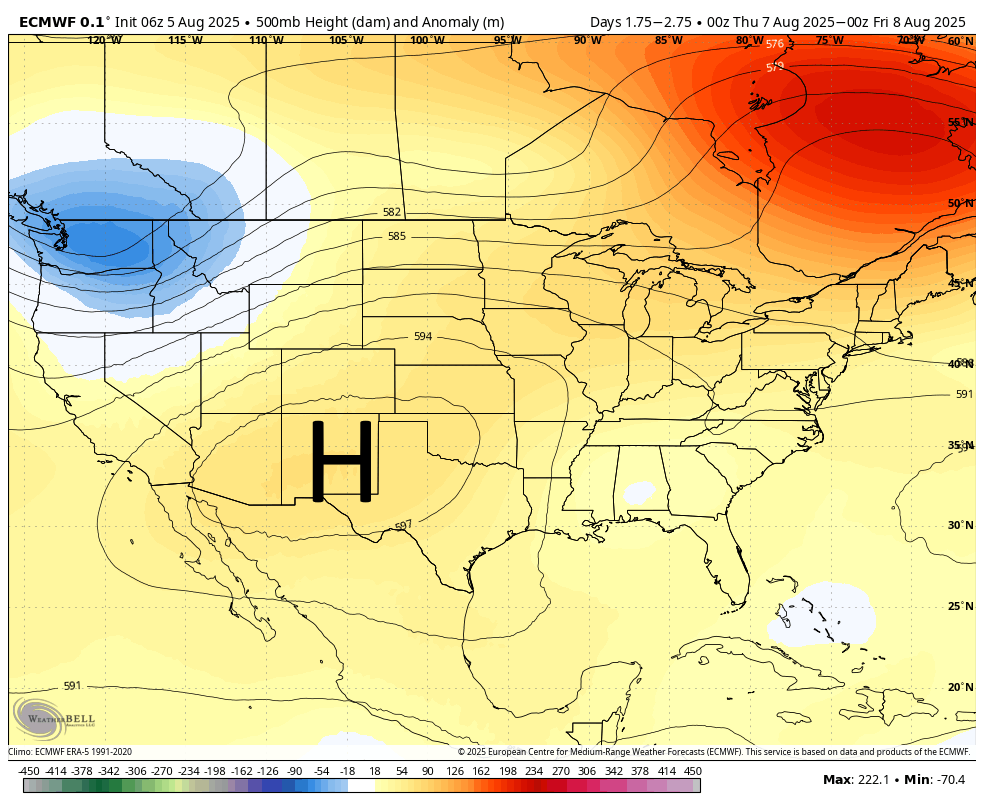
We remain on the edge of a very potent high pressure system anchored over the Southwestern United States, and that will continue to bring warm, mostly sunny days with a low-end chance of showers and thunderstorms. With this pattern we should continue to see high temperatures in the mid-90s for areas along and north of Interstate 10, and lower 90s for areas closer to the coast. Rain chances will be on the order of about 30 percent daily, with totals probably at the higher end toward the coast, and lower further inland. Humidity remains high, with light southeasterly winds. Nighttime temperatures will struggle to fall much below 80 degrees.
Thursday and Friday
These days will see a similar pattern, although daytime highs should be 1 or 2 degrees warmer, with some inland areas potentially reaching the upper 90s. A chance of showers is possible during the afternoon along the sea breeze.
Saturday and Sunday
The song remains the same heading into the weekend, although daily rain chances may nudge up to 40 or even 50 percent closer to the coast. These showers are unlikely to last too long, and for most locations will only bring a tenth of an inch of rain or two. For the most part skies should be sunny, with high temperatures in the low- to mid-90s.
Next week
Honestly, at this point not much change appears to be in the forecast for next week. If we’re getting through August with temperatures in the low- to mid-90s and the occasional shower to keep things green, then we’re doing August in Houston about as good as one can.
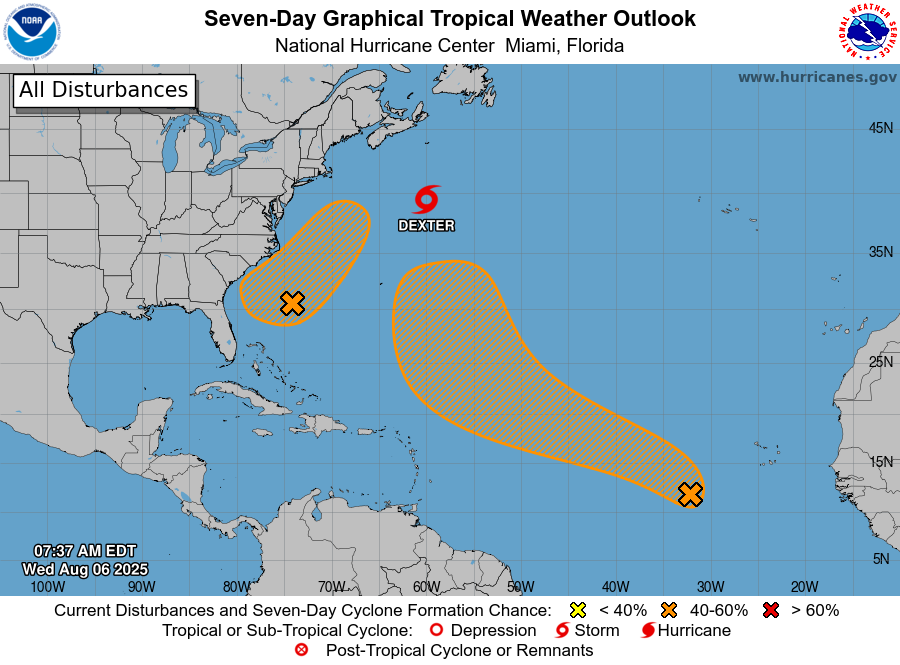
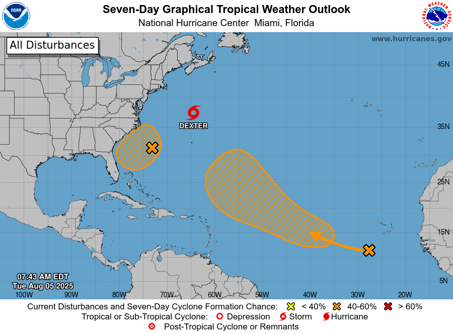
Tropical outlook for Wednesday morning. (National Hurricane Center)
Tropics
Dexter remains a weak tropical storm that is moving away from land, so no concerns there. Two other systems have a chance to develop, and one of them may bring increased rain chances to the southeastern United States over the next week. The Gulf looks clear for now, but we’re just about to begin a pattern of tropical systems forming in the “main development region” of the tropical Atlantic, and these will have a better chance of moving westward toward the Gulf, and potentially entering the body of water on our doorstep. Nothing is imminent, however. We’re just getting close to that time of year.
Once again, you’ve asked and we’re answering. Here’s our latest Q&A. Got questions of your own? Hit the Contact link at the top of the blog, or leave a question here in the comments. We’ll consider it for next time.
Q: I’m not complaining at all, but it seems like this summer has been cooler than usual? I know we’ve had a lot of rain and maybe that’s kept things cooled off but is something bigger going on? Is there an overlying thing in the atmosphere that’s made June and July less than hellish?
A: Good question! We’ve actually already answered it because we felt the same thing! So, ok. Let’s look at this again with July now in the record books. Through the end of July it was officially the 7th hottest summer to date on record in Houston dating back to the late 1800s.
June & July 2025 came in at #7 on the top list of hottest summers to date. (NOAA)
These temperatures are taken at Bush Airport, which about 20 percent of our audience thinks is complete blasphemy, another issue we addressed. And while Bush does have problems from a representation of Houston, when comparing to prior history at that specific location, it suffices. But, for those who would rather look at the data elsewhere as comparison, let’s do just that. At Hobby, it was the 15th hottest June & July on record back to 1931. In Galveston it was 4th hottest. College Station? 25th hottest. Corpus Christi was 9th. Beaumont was 44th! So, suffice to say there’s been variability across Southeast Texas. Was this really the 7th hottest start to summer “for Houston?” Officially, yes. In reality, probably not quite.
But it really depends on exactly where you are. And this gets to the reader’s mention of “a lot of rain.” Bush saw 9.46″ of rain in June and July, much less than last year of course, thanks especially to Hurricane Beryl. But if you took Beryl out of the equation it’s been a couple summers since we’ve had this routine amount of showers and storms. Hobby has had about 4 inches more rain this summer. Galveston has had far less, with about 4.5 inches officially. So it seems like the rankings of “hottest” are better correlated to rainfall than anything else. If you’ve seen more persistent daily storms in the Houston area, it’s been a good summer. If you haven’t, it hasn’t been horrible like 2022 and 2023, but it’s been a little hotter.
One thing I will note, that we’re basing this on average temperatures. When you look at nighttime lows, we’ve had more mornings at or above 78° this summer than in any prior summer in Houston. This persistence of warm nighttime lows is making a large impact on our overall average. This is for a number of reasons: A warming Gulf, urban sprawl and expanding heat island, and climate change. It’s just easier to have hot summers in Houston now than it used to be, even if the daytimes aren’t as bad as we’ve dealt with before.
– Matt
Q. Seems like we’ve had several low pressure systems near us (near shore) in the Gulf that IMO has really helped us with rainfall since June. Any chance these little low systems have pulled energy out of the Gulf that would keep something bigger from happening the next month or so?
A. The short answer is no, sorry. For two reasons.
First of all, it takes a stronger storm, preferably a hurricane, to really churn up lots of colder water from below toward the surface. This raising of colder water can produce a lingering effect on sea surface temperatures that reduces the energy available for subsequent storms to intensify. None of the weak systems we’ve seen to date have really been potent enough to have this effect.
Second, the effect is temporary, usually lasting on the order of two to four weeks. So even if the June tropical systems had a significant cooling impact on seas (which they really didn’t), it would be long gone.
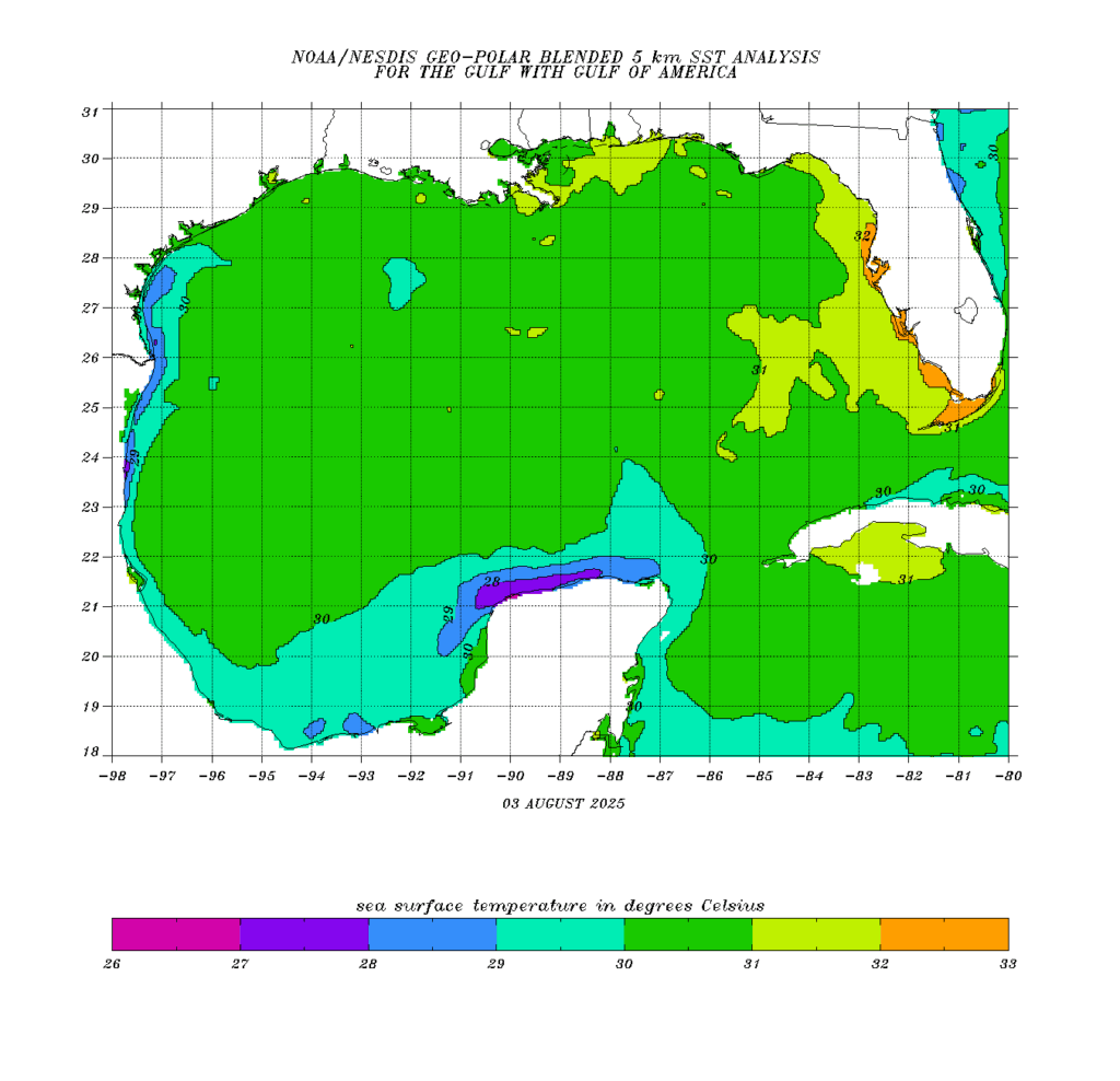
Speaking of Gulf sea surface temperatures, they are plenty warm. The vast majority of the Gulf lies at 30 degrees Celsius or higher, rather far above the threshold (roughly 26.5 degrees C) needed to support tropical system intensification. Buckle up!
– Eric
Q: Matt, I know you have written about cuts to NOAA and NWS, and you’ve said the forecasting and warning around the Hill Country tragedy was not affected. But is there anything now you can point to and say, “That happened because of these cuts”?
A: I stand by my initial assessment. I don’t believe the cuts, as implemented thus far played much if any role in this disaster. As we’re learning from the state legislature’s special session, it appears there’s a fundamental problem with emergency response to significant weather in Kerr County in particular. While the NWS San Antonio office was without a warning coordination meteorologist at the time of the flood, the relationship building that occurs to help mitigate the toll from this sort of event occurs over a long period of time. Could it have helped here? Maybe a little? No one knows for sure. Would it have prevented it? No. I feel strongly that this was sort of a terrible situation, wrong place, wrong time, wrong leadership type of situation. Hopefully there are lessons learned from this.
The caution here, of course, is that the cuts that have been proposed to NOAA in the administration’s budget would be catastrophic to NWS and increase the risk profile across the board for events of this and lesser magnitudes. It made absolutely zero sense from a public safety standpoint. Thankfully, both legislative branches are playing the roles of grown-ups in the room and have come back and said those cuts aren’t happening. What this looks like in the end remains to be seen. But to this point, what is being said by Congress is actually net positive for NOAA and NWS and the country at large.
As far as other significant weather events and the current budget cuts, we have not noticed other cases where we can say with authority that the cuts have played a detrimental role in outcomes or forecasts. There was the instance of tornadoes earlier this year in Kentucky immediately after the Jackson, KY, office announced they’d stop staffing 24/7 due to the lack of staff. But the office was open and operational that night. The outcome was suboptimal, and the cuts may have played a role there — but like a lot of things, we can’t exactly prove it outright.
Same goes for the lack of weather balloons. On at least 2 or 3 occasions this year in forecasting for both the Houston area and for my day job in the Midwest, I have noticed a couple “surprise” outcomes that I strongly suspect are tied to the lack of upper air data provided by weather balloons that has been inconsistent from parts of the Rockies and Plains. But again, that’s speculation to some extent. We know for a fact that these are bad decisions, but proving what role they’ve played in any one event is difficult to do.
– Matt
Q. I was looking at my records and thought “hmm, haven’t done my annual contribution to SCW yet, let’s find a link on their website”. But no, couldn’t find one. Are donations only while you’re having your annual thing, or did I miss something?
A. You’re very kind to ask this. We hold an annual fundraiser over the course of three weeks in November. During this time period people can donate money to support the site and buy merchandise for the holiday season. Speaking of which, do you have any ideas for a t-shirt design this year? We want to do something fun for our 10th anniversary.
Why only November? We don’t have a year-round fundraiser because I don’t want the site to be seen as trying to capitalize during inclement weather events. In November, things are usually fairly calm, so there’s no pressure on people to support us.
– Eric
Q. Your app keeps crashing. What’s happening? I thought you fixed it!
A. Sigh. So did we!
When last we left our cute little weather app, we had released a new version that fixed the longstanding issue preventing notifications on Apple devices. As we wrote in June, it took a while to get this done because Hussain Abbasi, our developer, needed to switch to a new coding platform – something he wasn’t planning to do until next year but Microsoft dropped support for it.
The notification problem was indeed solved, but as is often the case when you’re making a change as major as this, other bugs were introduced. After the new version had been out for a while, we began to get reports of crashes when the app launched. Hussain found the issue, having to do with how the locations in the city-picker drawer get sorted. A updated release with a fix for that is imminent – hang in there! (In the interim, deleting and redownloading from the App Store seems to solve the problem.)
See the list of cities you can choose on the left? That’s the cause of our latest iOS crash bug.
Meanwhile, he’s still in the process of getting the Android version working as it should via the new coding platform. Building Android apps can be more difficult because there are so many different hardware types and designs out there. In this case, you can blame folding Android devices for the delay – switching between tablet and phone layouts is creating, as he puts it, “inconsistencies.” (And there’s supposedly a folding iPhone coming next year. Yay?) Once we get an Android update out the door, it should also fix the issue of crashes on some Google Pixel phones.
It’s like playing whack-a-mole. Whack-a-bug!
Remember that you can send a bug report via the app. First make sure you’ve downloaded the latest version. Then tap the three-line icon next to the city name on the home page; tap the gear icon on the top right of the drawer that appears; tap the “Send Feedback” item. It sends a log with details on the crash to our developer, but it would help if you could provide as much detail as you can about what happened. (Details about your device are automatically sent.)
Does the app crash on launch so you can’t get to the Feedback button? Send as detailed a report as you can, including the device model and its operating system version, to [email protected].
And once again, just to be very clear: The spelling of Houmidity in the app is a feature, not a bug.
We appreciate your patience as Hussain works through these issues.
In brief: Rain chances will dial back, and temperatures will go up this week. But really, for this time of year, the heat could be significantly worse in Houston during the daytime. By the weekend much of the area could drop back into the lower 90s. Also, we discuss the likelihood of increased tropical noise.
Tuesday
There are some scattered showers along the coast this morning, and they should continue to push inland over the next couple of hours before dying out around Interstate 10. Later today mostly sunny skies should prevail across the Houston region, allowing high temperatures to push into the low- to mid-90s. Winds will come from the east at 5 to 10 mph. Low temperatures tonight will be in the upper-70s for most locations.
High pressure will be anchored over the southwestern United States this week. (Weather Bell)
Wednesday, Thursday, and Friday
There will not be much variability across Houston for the remainder of the week. A stout ridge of high pressure has established itself over the southwestern United States, but our area remains on the edge so we won’t experience the full force of its impact. Essentially, then, for the remainder of the week we are going to see mostly sunny days with high temperatures in the mid-90s, with inland areas possibly at risk of seeing the upper 90s. Humidity will, of course, be rather high. Each day will bring a slight chance of showers along the sea breeze, with higher chances of rain (maybe 30 percent) closer to the coast whereas inland areas see perhaps a 10 percent chance. These are the dog days of summer, and by golly they are going to feel like it. Please note it could be worse, however. Record highs for this time of year in Houston are generally in the 104 to 106-degree range.
Saturday, Sunday, and beyond
High pressure retreats a bit this weekend, and this will have a very subtle effect on our weather. Daily high temperatures will probably go a bit lower, so something like low- to mid-90s for much of Houston. And rain chances may go up slightly this weekend. Skies should still be mostly sunny, but there will be a chance for brief, passing showers on the daily. This overall pattern looks to hold at least into the middle of next week.
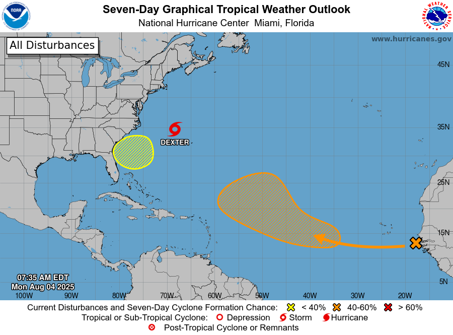
Tropical outlook for Tuesday morning. (National Hurricane Center)
Here comes the hurricane hype
As we noted yesterday, the Atlantic tropics are starting to heat up. And the seven-day outlook from the National Hurricane Center (shown above) indicates that. At present there are no threats to the Gulf, but looking at the longer range models there appears to be the potential for another tropical wave (which is still well over Africa, and not reflected in the map above) to move off into the Atlantic and follow a more westerly course over the next two weeks. This might eventually track toward the Gulf, but it’s a long ways off and there are a lot of ifs and maybes.
Nevertheless, you can probably expect to see a lot of noise from social media-rologists about this and other potential threats to the United States over the next two months. But right now, here’s all we can really say for sure: The Atlantic is heating up, and if Texas is going to be threatened by a hurricane, it will almost certainly happen in the next eight weeks. When there are more specific threats to discuss, you can rest assured that we will discuss them.
In brief: Houston will see a decent chance of some showers and thunderstorms today, but beyond this we should remain hot and mostly sunny, as is often the case in August. Also typical for August is an increase in tropical activity across the Atlantic. Which is what we are presently seeing.
Right on cue, the tropics heat up
After a flurry of tropical storms in late June and early July, the Atlantic tropics were rather quiet for the last three weeks. That has changed over the weekend with the formation of the fourth named storm in the Atlantic (Dexter, which is not a threat to land), and development of a couple of additional “blobs” to watch.
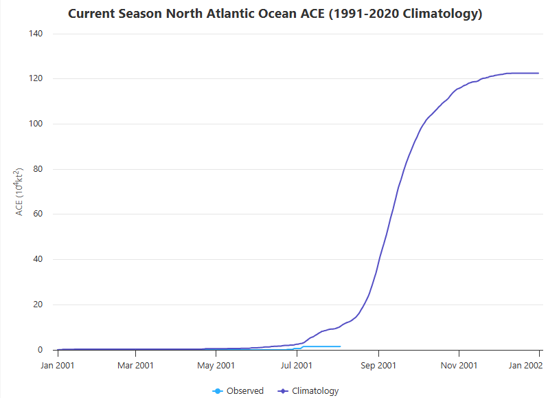
First of all, some numbers. Dexter is the fourth named storm this season, and in some sense we are ahead of schedule. Historically, the “D” storm forms on August 15th. This makes it sounds like it has been a busy hurricane season, but measured by a more accurate barometer, we have seen a slow start. Our preferred measuring stick for seasonal activity is “accumulated cyclone energy,” which factors in both the duration and intensity of tropical storms. By this metric we are running at about 20 percent of normal levels.
Accumulated Cyclone Energy to date compared with normal levels. (Colorado State University)
The graphic above highlights two things. One, we are off to a relatively slow start this year. But more importantly, we remain very early in the game. The vast majority of the Atlantic season’s activity remains ahead of us, with August and September as typically the busiest months. So yes, it’s nice to have had a quiet start to the tropics season in Houston. But it does not mean a whole lot.
When we look at the tropical forecast for the next week or so, there are no distinct threats to the Gulf of Mexico. And I don’t want you to focus on any specific storms. However, what is clear is that we are entering prime time for the Atlantic season, and the background conditions (including the upper air pattern) are starting to become much more supportive of tropical storms and hurricanes. Bottom line: we really need to pay attention to this stuff for the next eight weeks or so. We will cover every conceivable threat to Texas here, and be sure and check out The Eyewall for coverage of storms across the tropical Atlantic.
Monday
Showers and thunderstorms have developed offshore this morning, and I think we’ll see a healthy chance of similar storms developing over inland areas this afternoon. The overall pattern is not supportive of widespread storms, but I do think there will be some scattered but impactful activity this afternoon and early evening in the metro area, with perhaps slightly higher chances west of I-45. Some areas may pick up 1 inch of rain or more, with most of the region staying dry. Otherwise expect mostly sunny skies this afternoon with high temperatures generally in the low- to mid-90s. Winds will be light outside of thunderstorms, from the east. Lows tonight will only drop into the upper 70s.
So it goes in August, in Houston. (Weather Bell)
Tuesday, Wednesday, and Thursday
A fairly robust ridge of high pressure will build over the southwestern United States this week, but Houston will fall on the eastern periphery. Essentially, this means that we will see typical August weather, with mostly sunny skies, highs generally in the mid-90s (with some upper 90s for far inland areas possible), and a low-end chance of showers during the afternoon along the sea breeze. Nights will be warm and muggy. As Augusts go, things could certainly be worse at what is typically the very hottest time of year in Houston.
Friday, Saturday, and Sunday
Not a whole lot changes as we head into the weekend. Skies remain mostly sunny, and I think most of us will continue to see daytime highs in the mid-90s. Rain chances remain low, but at about 30 percent daily, are definitely not zero thanks to the sea breeze. I don’t see much of a change in this pattern any time soon.