In brief: We should see two more days of some of summer’s hottest weather to date before a tropical disturbance brings clouds and rain chances Friday and Saturday. We start to heat back up again next week with another round of 100° risk possibly beginning on Tuesday.
Yesterday bested Monday for Houston’s hottest day of summer. We officially hit 100 degrees for the first time since August 22nd of last year. Congratulations. This is our 4th summer in a row with at least one 100 degree day. 2021 had none. For real.
Today and Thursday
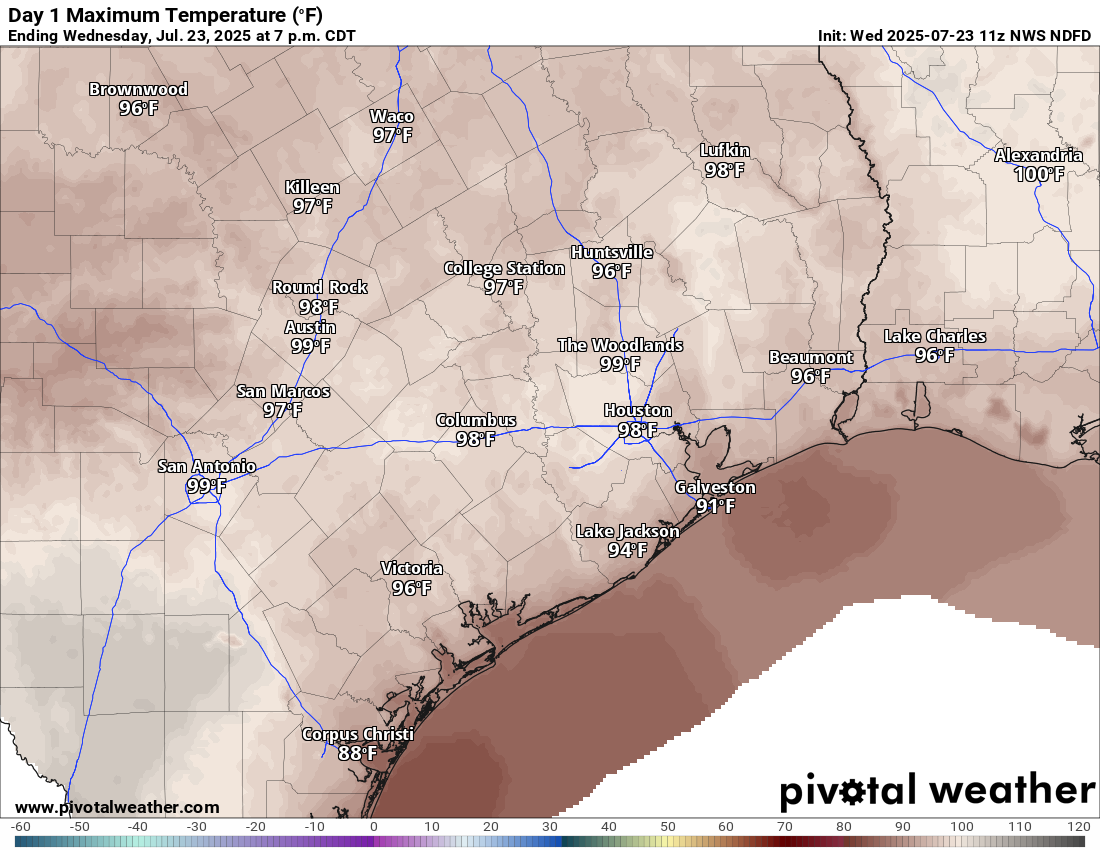
More heat. More humidity. More ouch. We will probably threaten yesterday’s hottest day of summer record on either or both days.
High temperatures today will be similar to yesterday. Sizzlin’! (Pivotal Weather)
Rain chances will be at a minimum.
Friday & Saturday
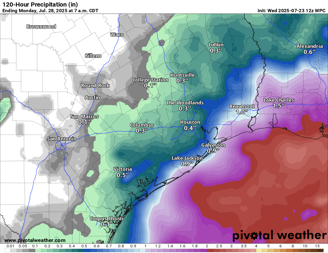
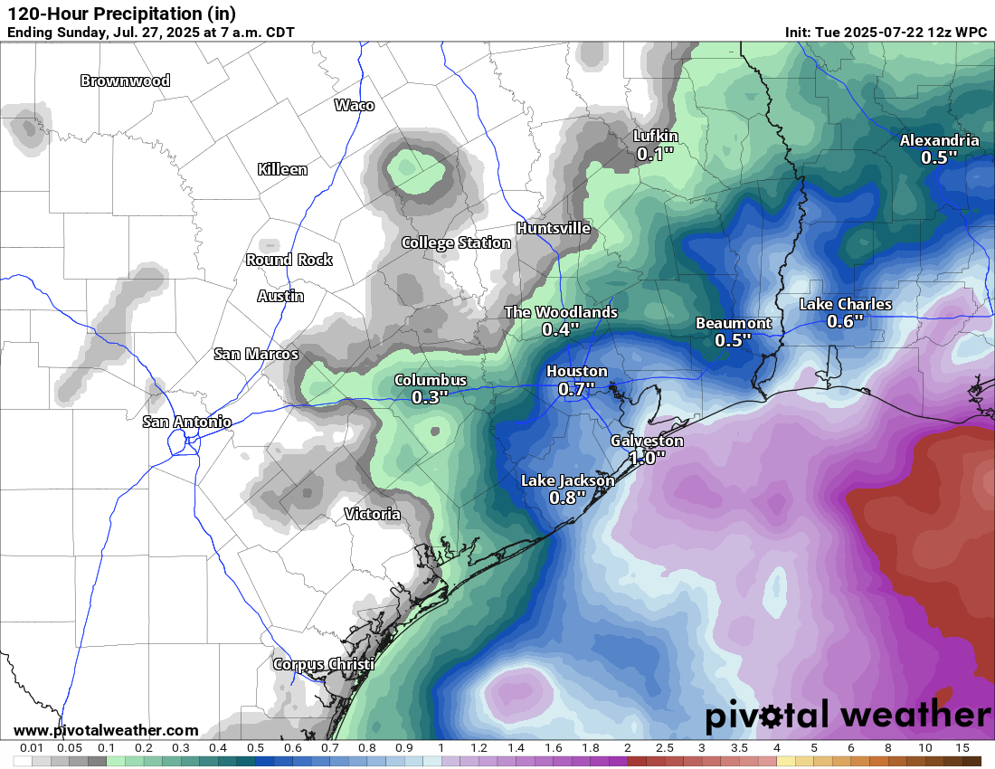
We continue to see plenty of signs that the tropical wave moving across the Gulf will “make landfall” in Southeast Texas on Friday. No development is expected (though the NHC did tag it at 10% yesterday evening). However, it will nudge up our rain chances substantially on both Friday and Saturday, especially near the coast and east of Houston. Rain chances will also spread inland too. But the best chance of some locally heavy rainfall will be south and east.
The heaviest rainfall from an approaching tropical disturbance will be along the coast or to the south and east of Houston on Friday and Saturday. (Pivotal Weather)
I’m not sure I would go cancelling outdoor plans just yet. You may still be able to squeak some windows in of drier weather on those days, particularly away from the coast. But stay tuned.
Temperatures will be held back due to clouds. Look for highs in the low-90s at best, possibly upper-80s in a couple spots, especially south and east.
Sunday & Monday
We should transition out of this pattern at the end of the weekend and on Monday. Look for highs to bounce back into the mid-90s or even a bit hotter by Monday.
Tuesday through Thursday
I would expect us to see another round of heat rivaling the hottest of summer beginning next Tuesday. Highs will approach 100 degrees in spots. Rain chances will again be minimal. Or so we think. If the ridge of high pressure over the Plains orients a little further north, it could crack the door to the Gulf open some more. If that happens, we could possibly see more cooling downpours each afternoon. We’ll see. More to come.
In brief: After Houston’s hottest summer day so far, more heat is likely to persist today through Thursday. A tropical disturbance (that will not develop) will bring ample rain and storm chances back to the area Friday and Saturday before we jump right back into the hot stuff next week.
Summer to date in context
Since the weather is pretty cut and dry the next few days, let’s talk briefly about this summer. Officially, yesterday was our hottest day of the year, with a daily average of 89 degrees at Bush Airport, besting the 88.5° we hit 4 times, last on June 21st. But someone messaged us on Instagram recently asking if it was a pretty mild summer so far. “I’ve been able to enjoy the mornings and evenings outside which hasn’t always been the case,” they noted. And, I had to agree! It’s been hot, just as every summer is, but we’ve had enough rain chances (almost daily it seems) to break it up. It’s felt kind of like what would be a typical Houston summer.
And then Lee Corso barged in and said, “Not so fast, my friend.”
Statistically, from June 1st through Sunday, this has been the 7th hottest summer on record to date in Houston. In fact, we’re even a smidge hotter than 2024, though significantly trailing 2022 and 2023 to this point. We have averaged 84.9 degrees officially. This is about a solid 2 degrees warmer than normal. So why has it seemed less intense? In a word, the daytimes. Our daily high temperatures average 19th hottest on record. In other words, although this is one of Houston’s hottest summers on record to date, it hasn’t been that bad during the daytime. So it hasn’t seemed too intense. And on the days that it has been bad, we’ve often had rain showers to punctuate things. However, if you look at nighttime lows? It’s the 3rd warmest summer on record to date, trailing only 2022 and 2023 and only one spot ahead of 2024. Notice a pattern?
It hasn’t been our wettest summer on record, but it has been pretty consistent each afternoon up til now. (High Plains Regional Climate Center)
So factor it all together: Modestly hot days, punctuated by daily thunderstorms, followed by a bunch of persistently warm nights, and you get the seventh hottest summer to date in Houston that doesn’t feel all that terrible. It’s a weird outcome, but the numbers don’t lie.
Today through Thursday
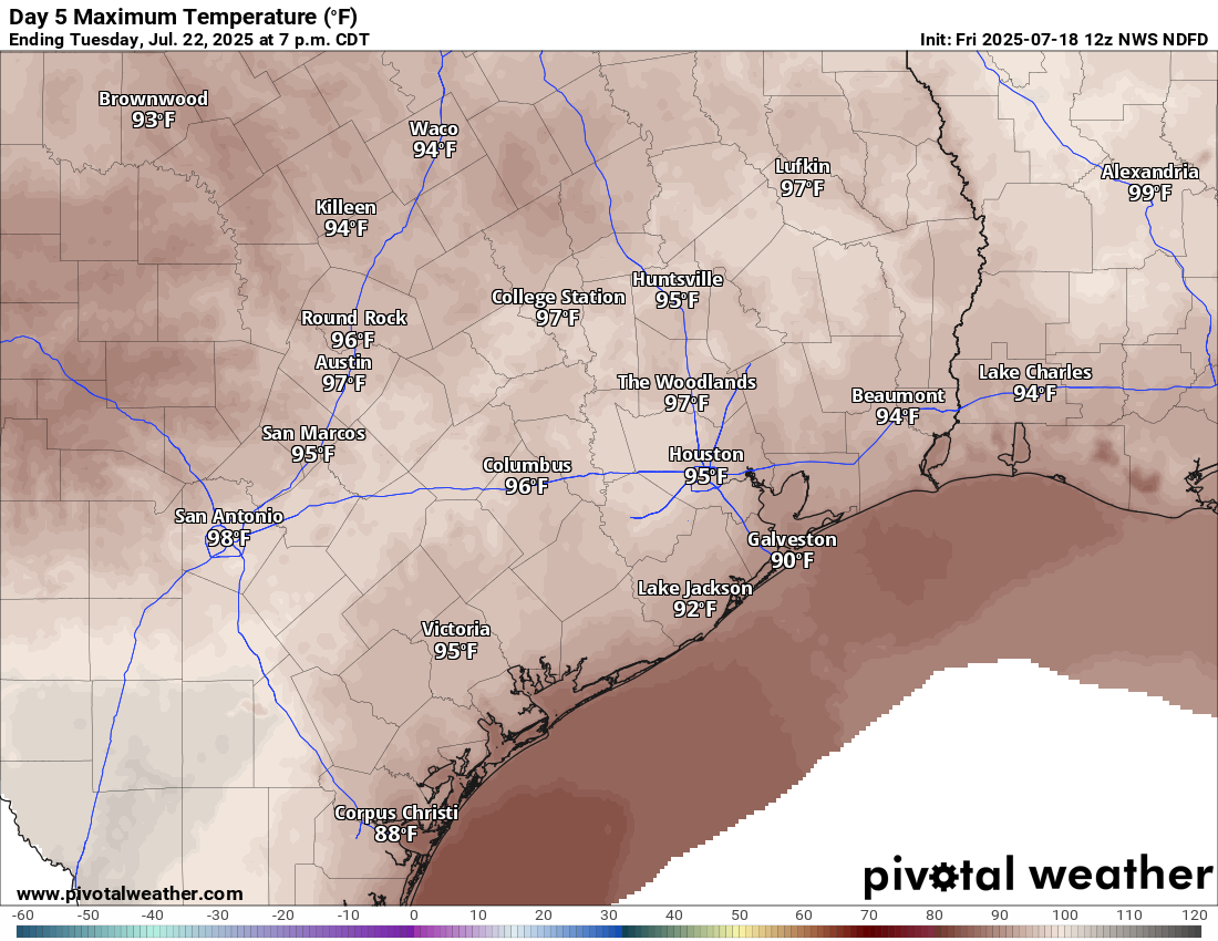
Look for the heat to keep up the next 2 to 3 days. Each day will probably top off in the mid to upper 90s. I would not be the least bit surprised to see a few spots hit 100 degrees before Thursday is out. Given that this is the hottest weather we’ve had in a month and the hottest of summer, give yourself a little grace out there and take it easy, stay hydrated, check on pets, check on the elderly, and always check the backseat before you lock the car.
High temps will likely push 97-99 degrees for most inland locations tomorrow and Thursday, with a few spots aiming for 100 degrees. (Pivotal Weather)
Friday and Saturday
The remnants of our old friend, Invest 93L are diving into the Florida Peninsula today. This system will enter the northwest Gulf on Wednesday, track west on Thursday, and it will probably come ashore between Matagorda Bay and Cameron, Louisiana on Friday. No development is expected, as wind shear is too hostile, and dry air is likely available for disruption. But, what it will do is pick up our shower and storm chances to close the week and start the weekend.
The NWS rainfall forecast through Sunday morning shows the best chance of more meaningful rain south and east of Houston. (Pivotal Weather)
We are probably looking at a 40 to 60 percent chance of showers and storms on Friday and Saturday. This will allow high temps to plunge back into the low-90s. With enough clouds and rain, we may only make it to 90 degrees on either day in a few spots. In terms of total rainfall, it will not be uniform, as some areas will see modest amounts or little rain, while a few other locations could pick up 1 to 3 inches of rain, probably east of Houston or closer to the coast it seems right now. More on this tomorrow and Thursday.
Sunday into next week
That disturbance will exit on Sunday, lowering rain chances again. I would expect highs to return to the mid-90s by Sunday and then upper-90s at times next week, as a monster ridge of high pressure sets up over the Southern Plains. We will probably flirt with the hottest weather of summer again for much of next week.
In brief: As we approach our typical peak of summer heat, we’ll be seeing an uptick in temperatures through the week. We should see potentially upper-90s to near 100 in spots by late week before some shower chances re-enter the forecast. Even hotter weather is possible next week.
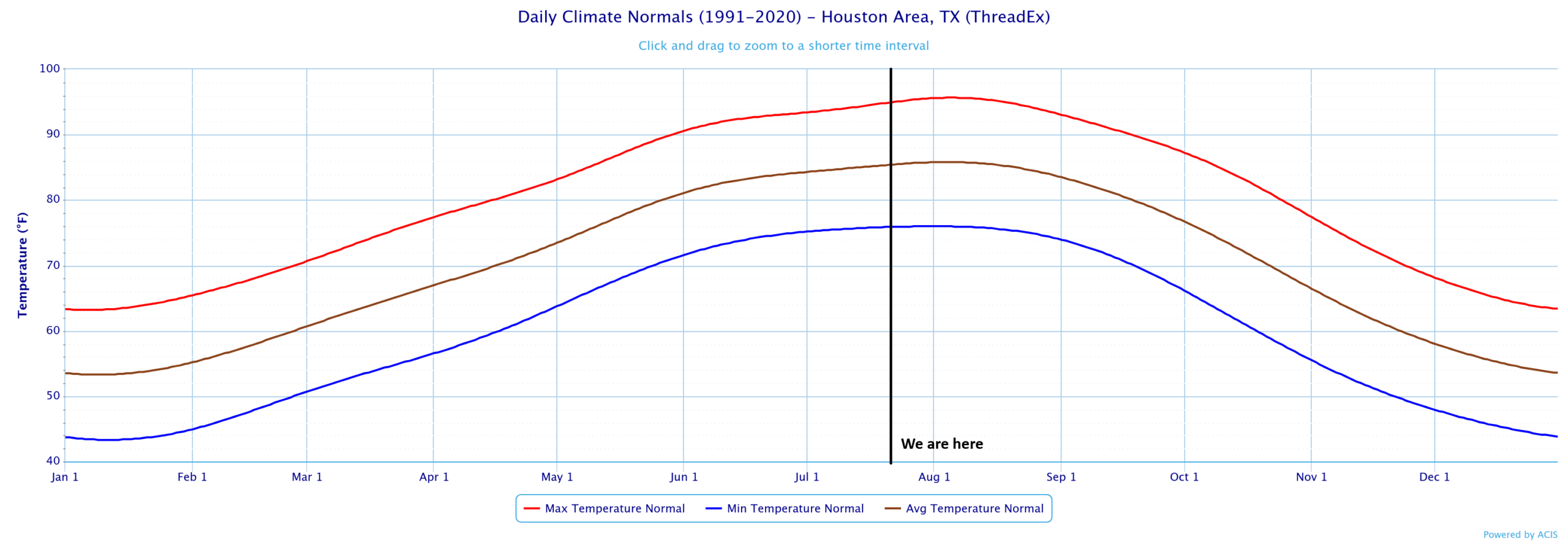
Houston’s summer heat typically peaks between July 29th and August 12th, when our average high temperatures sits at 96° and our average low temperature is 76 degrees. The actual peak date is probably around August 5th. So, we are nearing the top of the mountain, and this week may prove to include our hottest weather of summer.
A chart of daily normal high, average, and low temperatures for Houston from 1991-2020, showing that we’re near the worst of it now. (NOAA)
Today through Wednesday
We will start the week with heat and humidity that slowly builds. Highs will push into the mid and perhaps upper 90s by midweek. Thunderstorm chances, while not quite zero each day are fairly low. Morning lows are likely to be in the upper 70s.
Thursday and Friday
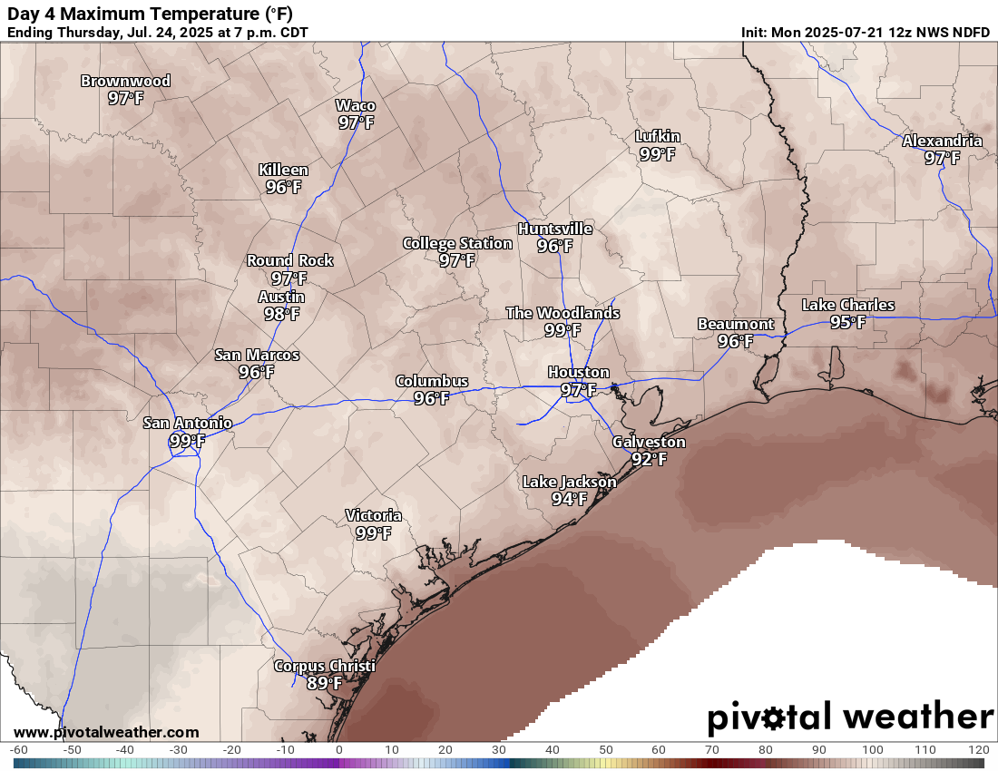
I have a feeling that Thursday may be the hottest day of the week. And if not, then it will probably be Friday.
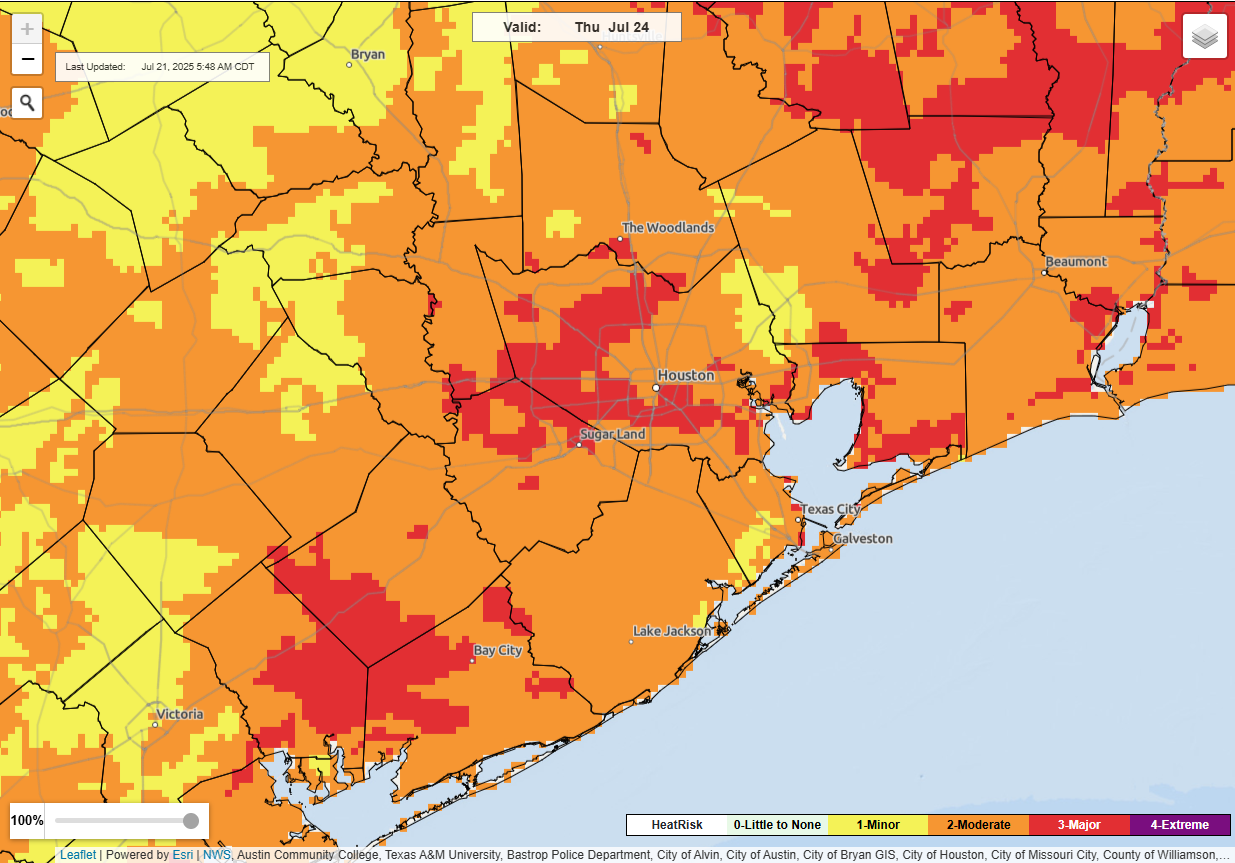
NWS HeatRisk outlook for Thursday shows major, but not extreme heat impacts. That said, expect some of the hottest weather of summer so far this week. (NOAA)
The National Weather Service’s experimental HeatRisk product puts our area in high risk on both days, with a strong edge to Thursday right now. Either way, expect some of the hottest weather of summer so far this week.
Thursday’s forecast highs. (Pivotal Weather)
By the time we get to Friday, we may see showers or thunderstorms re-enter the forecast, depending on the track of a tropical wave in the Gulf. No development is expected, but a similar track to last week’s Invest 93L is possible, which could keep most of the rain to our east again — or a somewhat more southerly track could bring higher rain chances to our area by Friday. Something we’ll watch through the week, but the main takeaway here is that, again, no development is expected.
Weekend and beyond
Once that wave passes, we should sort of resume a typical summer pattern of heat, humidity, and slight daily storm chances in the area. It does appear that a very strong ridge of high pressure in the upper atmosphere is going to establish over the Southern Plains next week.
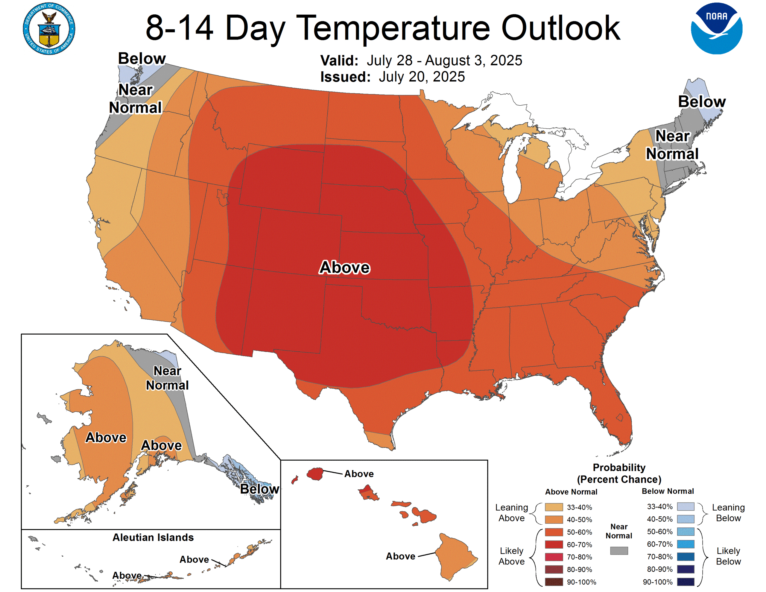
The 8 to 14 day outlook which covers next week suggests a high likelihood of hotter than normal weather in all of Texas. (NOAA CPC)
We may be on the periphery of it enough to get continued shower chances each afternoon, but if this flexes much further, we may see even hotter weather next week, perhaps the hottest of summer. Stay tuned.
In brief: Invest 93L is kaput, and now we will look for some heavier downpours in spots today. Rain chances begin to dwindle on Saturday and Sunday as a hotter, less unsettled pattern establishes over our region for much of next week.
Today
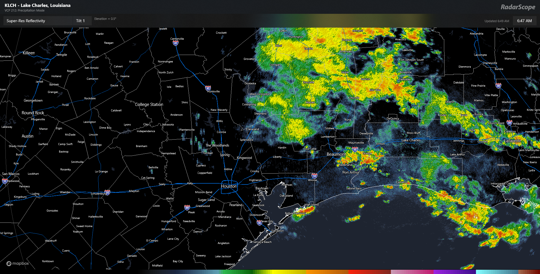
Our best chance of rain will come today. The radar as of early Friday morning shows widespread rain north of Liberty and in Louisiana. Additional, more isolated thunderstorms are popping up along I-10 near Beaumont and on the Bolivar Peninsula.
Radar as of 6:45 AM shows some coastal showers, heavier showers near Beaumont, and some steady light to moderate rain to the north. (RadarScope)
As we go through today, a lot of that steadier rain north of I-10 will probably dissipate. Even some of the thunderstorms this morning may fizzle. But a new round of scattered thunderstorms is likely this afternoon. For the most part, this will be like any other summer afternoon in Houston. Available atmospheric moisture will be a bit higher than usual though, so just be on the lookout for a downpour or two that could briefly flood streets in some parts of the city. Storms should fade after sunset.
Saturday
There should be a somewhat decent lingering shower chance here, but for the most part, any added moisture from the Invest 93L (RIP) would be exiting. I wouldn’t be floored to see a couple heavier downpours in the area though. Look for highs in the mid-90s.
Sunday through Tuesday
We’ve had very few days this summer that carried virtually zero rain chance. It would appear that Sunday through Tuesday carry good chances for that to be the case, however. Look for mostly sunshine. Another bout of Saharan dust could come our way Monday and Tuesday. For now, I’ll say mid-90s, but if the Saharan dust is minimal Monday and Tuesday, we do have a decent shot at upper-90s on those days in some parts of the area.
High temperatures on Tuesday will be near to slightly above normal. (Pivotal Weather)
Late next week
The heat should stay cooking for later next week, with highs in the mid to upper-90s continuing. We may even see a stronger surge of heat later next weekend or the week of the 28th. Rain chances may pick back up a little by Friday or next weekend. Overall, it looks fairly dry next week across the region.