In brief: Spring effectively ended on Monday after two lovely weekends in a row. But that’s all over now as summer has arrived in Houston. Expect hot and sunny weather to prevail for at least the next week, and probably beyond.
An almost summer-like setup
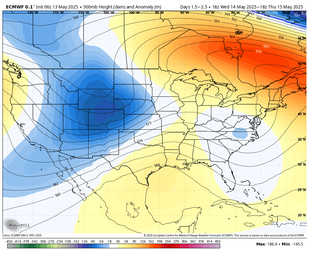
High pressure has begun to build over the region, and this will continue to intensify over the next few days. This means sinking (rather than rising) air, and mostly sunny days. In addition to this we are seeing a southwesterly flow in the atmosphere, bringing warm air into the region. This is a classic setup for hot temperatures, and although it is just May this is the pattern we are going to experience for at least the next week, if not beyond. In my opinion the 90s was an excellent decade, I would argue the best decade, but I’m not sure its the temperatures I want to feel in May. But here we are.
The Texas coast will fall under high pressure ridge this week that will bring hot and sunny weather. (Weather Bell)
Tuesday
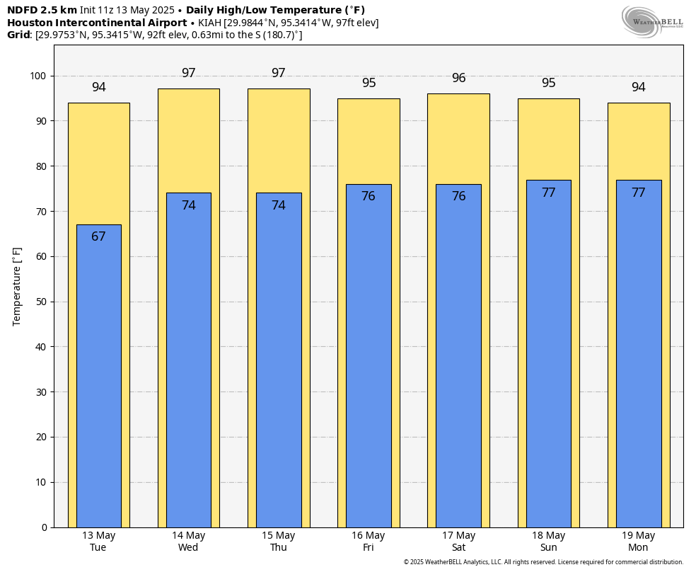
As a result of this pattern we can expect mostly sunny skies today, with high temperatures in the low- to mid-90s across the city (the coast may be slightly cooler). Southerly winds will be gusty this afternoon, up to 20 or possibly even 25 mph. And we can more or less expect the same southerly winds, peaking during the afternoon, for the next week. Low temperatures tonight will unlikely fall much below 75 degrees. Oh, and there will be humidity. Plenty of it. Rain chances are near zero.
Very hot for mid-May this week. (Weather Bell)
Wednesday through Sunday
The above pattern will more or less persist through the weekend. I think temperatures will peak on Wednesday, with many locations possibly reaching the upper 90s, but we should come down a couple of degrees by the weekend. But this is splitting hairs, really, We are looking at sunny and hot weather during the daytime, and partly cloudy and muggy nights. If you’re heading to central Texas, the heat will be scorching there. Austin is expected to smash daily high temperature records by as much as 10 degrees, with a high approaching 107 degrees on Wednesday.
Next week
At this time I don’t expect much change at least for the first half of next week. Highs will likely remain in the 90s. We may start to see some spotty showers as the upper air pattern changes a bit, but once we get into these hot and rain-free patterns, long-time residents will know they can become difficult to break.
In brief: The calendar reads May 12, but although June remains several weeks away today is the final day of spring for this year. Beginning tomorrow summer arrives in Houston and it does not appear likely to relinquish its grip. The region faces hot and sunny weather for awhile.
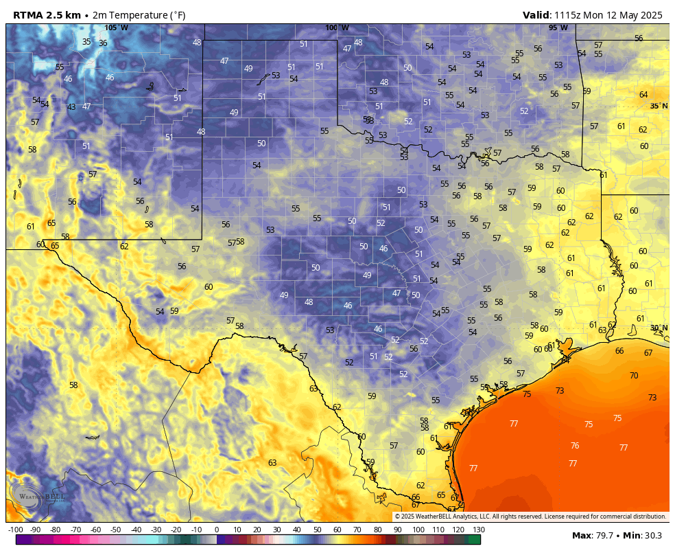
Monday morning temperatures in Texas: It is almost certainly the last time the state will be this cool until at least September. (Weather Bell)
The end of spring
Looking back with hindsight, we might say that spring began on February 26 in Houston this year, a day when the high temperature reached 82 degrees. From that point forward, the city would not have any more daily highs below 69 degrees. And all things considered, it has been a rather warm spring, with both March and April recording average temperatures more than 4 degrees above normal. However, May so far has been temperate with near normal highs and lows, and a pair of pretty spectacular spring-like weekends. For those dreading the onset of summer it has been mighty fine. Sunday evening, with sporadic sunshine and dry air, was just an incredibly fine time to be outside.
But all good things must come to an end. And we can say with high confidence that spring will end today. Consider this morning the final hurrah. It sure may not feel like it outside right now, with much of the area dropping into the upper 50s. Indeed, it feels almost chilly outside. But believe me, this is it. The high today will be fine, in the mid-80s for most locations. But tonight will be warmer and more humid, and then by Tuesday we’re off to the races with a high temperature likely reaching the lower 90s. Maybe we will get a final, weak front 8-10 days from now, but it’s not something I’d bet on.
Monday
Much of the Houston region has fallen into the upper 50s or lower 60s this morning, and it feels positively spring like. Winds are generally calm this morning, and may yet come from the northwest for a few more hours today. This will help hold dewpoints in the 50s for much of today, helping keep humidity levels low through this afternoon and early evening. With clear skies high temperatures will likely reach the mid-80s. By tonight we will fall into a much more southeasterly flow, allowing for humidity levels to rise. Lows tonight will only drop into the upper 60s.
Tuesday
Southerly winds will become much more noticeable on Tuesday, with gusts up to 25 mph or perhaps even a bit higher. With this southerly flow skies will be mostly sunny, and high temperatures will reach at least the lower 90s. Tuesday night will be warm, with lows dropping only into the mid-70s.
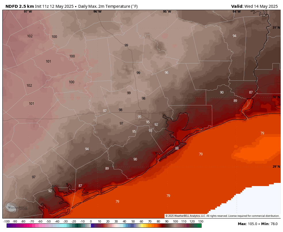
Wednesday should be the hottest day of the week. (Weather Bell)
Wednesday through Sunday
High pressure takes control, and we are going to see a hot week. Look for partly to mostly sunny days with high temperatures in the mid-90s, and mostly cloudy nights with lows in the upper 70s. Some inland locations will get into the upper 90s, with Wednesday likely to be the hottest day of the week. Rain chances will be virtually non-existent. With dewpoints around 70 degrees, the humidity will feel summer-like. From day to day there will be very little change in the weather, but there might be a very slight downturn in temperatures by the weekend.
Next week
The uncharacteristically hot pattern will persist into next week before some kind of front slides into the state. Whether it makes it all the way to Houston remains to be seen. But that will bring our best chance of rain for the next 10 days.
In brief: A few showers will dot the radar around Houston today and tomorrow. We’re optimistic that Mother’s Day will turn out mostly fine. But next week? It’s gonna get hot, like June or July-type heat.
SCW Flood Scale
I want to start off with a quick note today. If you’ll recall, back in January of 2023, I had posted that I gave a talk about the SCW Flood Scale at the American Meteorological Society’s annual meeting in Denver. We said we might have some opportunities to partner up with some experts to improve the scale. We love the scale, and we know you do. And while it works, we came up with it ourselves. It’s rooted in what we thought worked. Well, the goal was to get it rooted in science.
Thanks to the passion and interest of Dr. Steven Woods, the director of the Cognitive Neuropsychology of Daily Life Laboratory at the University of Houston and his PhD student, Natalie Ridgely, we may have a solution. Natalie conducted a bevy of research to understand how people consume weather information. Natalie just successfully defended her dissertation research this week, much of which comes out of her work that uses our flood scale and proposed modifications to it! I was honored to serve as a member of her dissertation committee, and I cannot wait for Natalie and Dr. Woods to share more details on this in the weeks and months ahead. Natalie’s findings are fascinating and illuminating and will become a great contribution to both neuroscience research and research of the societal impacts of meteorology. And they’ll have a permanent impact on our flood scale. Congrats to Natalie! More to come.
Overnight storms
So, yes, last night we had a few hours of storms right across the middle of Houston. Many of you missed out, but many of you participated. Thankfully, they were not severe, but they certainly had some noise — and rain.
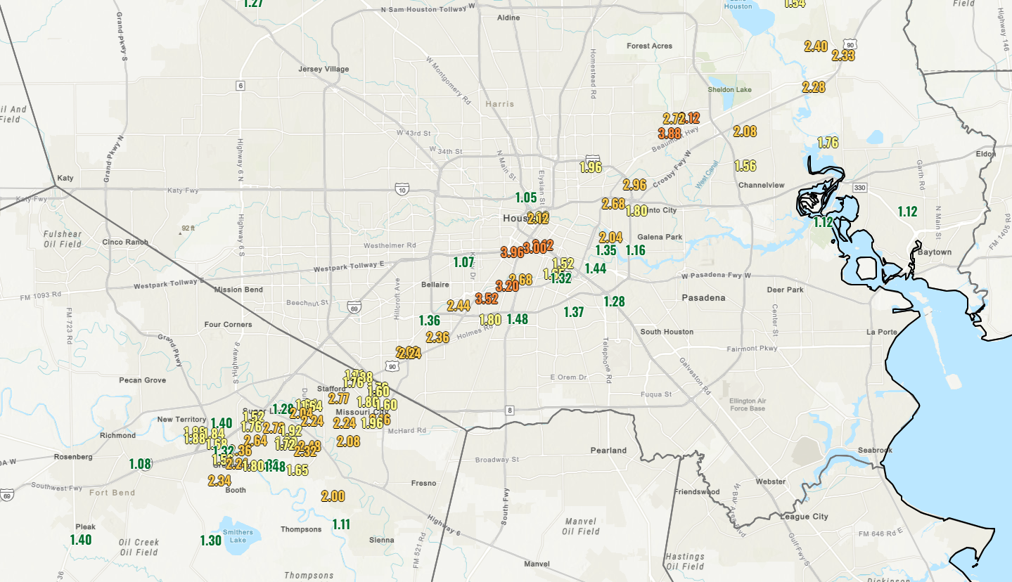
Rain totals that were over 1 inch last night lit up along Hwy 59 and US-90. (NOAA)
The big winner was the area between the Med Center and UH, where a max total of nearly 4 inches occurred. A secondary maximum was just west of Sheldon. Rain rates were on the order of 2 to 4 inches an hour. They were some hefty downpours. Some pockets north and west of downtown also saw around an inch or so, but for the most part it was that corridor that got soaked.
Today
We have one last little broken line of showers rolling through the area now. Some heavier downpours are occurring southeast of the city across Brazoria County.
Radar shows a broken line of showers this morning with some embedded heavier downpours. These will exit the area by late morning. (RadarScope)
These will exit over the next couple hours, giving us a quiet middle of the day. With any sunshine will come some additional showers and perhaps storms today. The best odds of showers later today will probably be north of I-10, probably across Montgomery, Walker, Liberty, and San Jacinto Counties. With low pressure in the upper atmosphere over Louisiana, these showers will basically drop north to south.
Saturday
It looks like one little disturbance in the upper atmosphere is going to pivot around the upper low in Louisiana tomorrow, so I think our odds of scattered showers or thunderstorms actually may go up a bit, relative to this afternoon. These would probably pop up in the late afternoon and evening hours. So just have an umbrella handy for any Saturday evening plans. Look for highs in the upper-70s to near 80 degrees.
Mother’s Day
Drier air is going to begin pushing into the area on Sunday. I don’t want to completely take a rain chance out, especially east of I-45, but any showers on Sunday should be fleeting. And overall, any plans you’ve got should have minimal to no weather disruption with mostly sunshine otherwise. Highs should top out near 80 or so on Sunday.
Next week
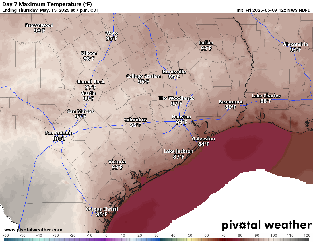
Welp. There’s almost always a week in May where it becomes apparent that the season is about to change. Next week should be that week. Monday looks great, with a cool morning, highs in the lower 80s and comfortable humidity. By Tuesday we bounce into the upper-80s. Wednesday? Low-90s. Thursday we head into the mid-90s. And to be honest, I would not be shocked if we end up in the upper-90s by Friday or Saturday.
Mid to upper 90s are back by next Thursday. (Pivotal Weather)
These will begin to approach record highs. The humidity should also transition back above normal later next week, probably making it feel a bit more uncomfortable. It should hopefully fall short of the intense heat and humidity we saw last May, but either way, brace yourselves, summer is coming.
In brief: Good evening! Matt here with a quick update for you on the weather that has, well, escalated across Houston. I am currently writing this from my son’s bed because some of the lightning (as many of you will attest) was too close for comfort.
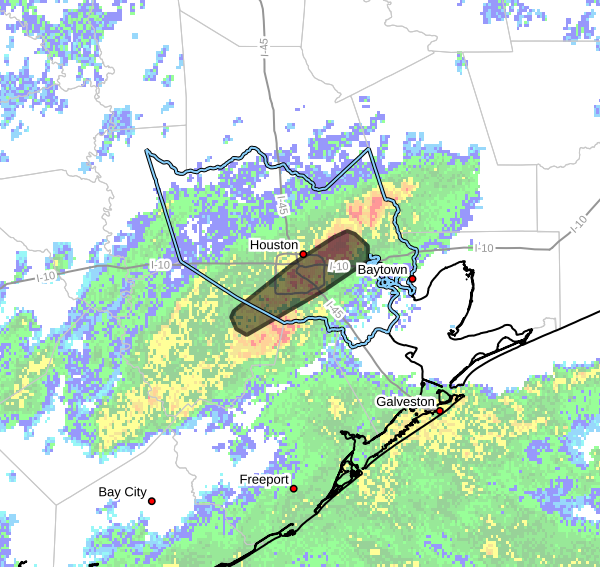
As of 10:30 pm CT we have a nearly stationary line of thunderstorms anchored over the Highway 59 corridor, or on either side. It’s maneuvering around a bit but not enough to avoid some developing flooding issues. There is a flash flood warning in effect for this area until midnight.
Area of flash flood warning in effect until midnight. (National Weather Service)
Rain rates have been on the order of 2 to 4 inches an hour in the heaviest downpours. We would advise you to drive cautiously this evening. Based on modeling, our best guess is that this may continue through 12-2 AM and then quickly push out of here. Storms exiting the Texas coast to our south should help to get that going. But there is certainly a hint of uncertainty given how this system developed into unexpectedly potent showers and thunderstorms.
We will have the latest for you in the morning or overnight if for some reason things continue to get worse.