Good afternoon. We just want to offer an update on the upcoming rain situation for Houston, as it continues to look like a pretty significant event will unfold tonight over the region. If you read our post this morning, we told you that later today and tonight would be the issue. So just because it’s been dry today for most of us, don’t think this event is a bust. Things are going to change quickly tonight.
Key points
- Scattered strong to severe storms this afternoon with large hail a possibility.
- Weather deteriorates rapidly after 7 PM this evening, and if you can stay home for the balance of the night, it is advisable.
- 1-4″ of rain on average tonight with some pockets seeing 4-8″ or more.
- Rain may end after 2 AM or so, leading to a dry start to Friday.
- More rain to come tomorrow night and Saturday.
Next few hours/severe weather
There are a handful of downpours across the region today, but thus far, nothing significant has developed. Through about 4-5 PM, we should see this kind of story continue. After 4-5 PM, weather modeling is in good agreement that more numerous storms will begin to pop up. Given that the atmosphere has had all day to destabilize (and it has done so rather considerably), any storms that form late this afternoon will be capable of large hail and strong winds. Isolated tornadoes cannot be ruled out either.

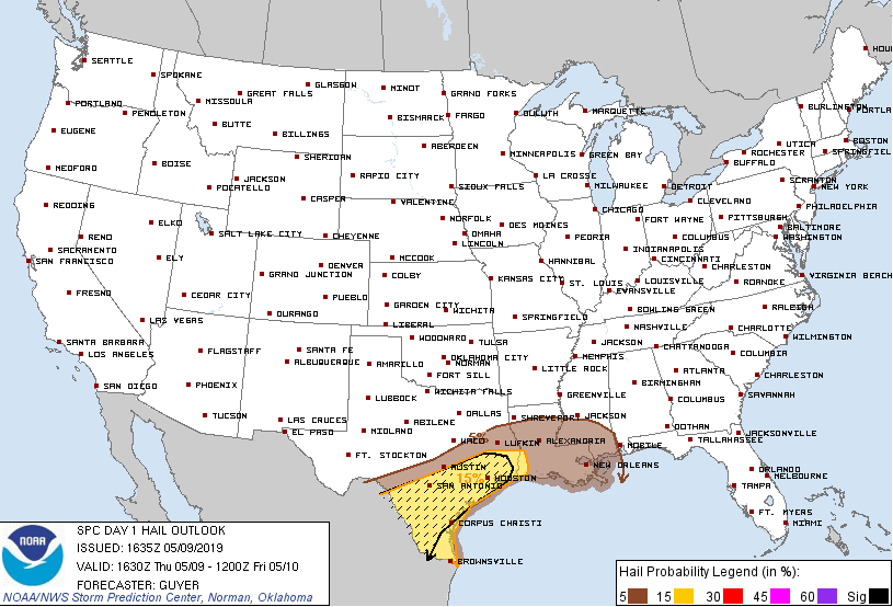
Severe weather is a distinct possibility anywhere in the area this afternoon and evening, but especially south and west of Houston. In fact, the Storm Prediction Center has us in a “hatched” area for hail risk now, which basically means that significantly large hail is possible.
Tonight/flooding concerns
I have looked at a lot of data today, and it seems to me that consensus favors a steady, significant escalation of rain after about 7 PM tonight. If you don’t need to be out on the roads after 7 PM, we would strongly advise you stay put. If you do have to be out, please make sure you have a safe route to get where you need to go, or stay put until conditions improve. Flash flooding is most dangerous and hardest to see at night. Storms will become more numerous and likely to setup over the heart of the Houston metro area, focusing along or north of I-10 initially, and then drifting slowly south as the night progresses.

Rainfall rates of 1 to 4 inches in an hour will be possible anywhere in the Houston area tonight and with storms likely to track repeatedly over certain areas, street flooding is likely in parts of the city and suburbs and bayou or additional river flooding is a very good possibility as well.
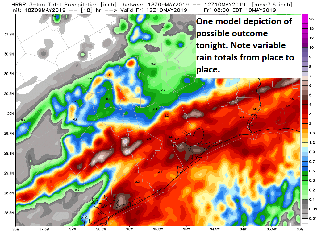
The image above shows the HRRR model’s forecast of total rainfall between now and 7 AM Friday. Don’t focus specifically on what it shows for your area, but rather just note the big picture idea it shows for the region: A widespread 1 to 4 inch rain, but “lollipop” totals that are much higher. Those are the areas we are especially concerned with for something worse than just street flooding, and those could be the ones that see as much as 4 to 8 inches or even more. So that is why we are very concerned about tonight. As I said this morning, it will not flood everywhere, but it could flood anywhere in the region. We will know more about which areas those could be later this evening.
A strong boundary or front could cross through the region after about 12-2 AM or so, which should kick most of the rain off to the east, allowing most of us to dry out a bit toward morning, but at that point the damage will have been done.
Beyond tonight, we should still see at least some scattered storms tomorrow, but the focus may be south of Houston. Look for another wave to lift heavy rain and storms through the Houston area tomorrow night and Saturday, with more flooding a possibility. We will worry about that tomorrow. We will have more later this evening, as the rains unfold.

Hail, that’s surprising considering how it’s quite hot out today
Given hail is created high up in the clouds where the temperatures are much much colder, before it plummets to Earth, that is not surprising at all. I’ve experienced hail several times in the summer, totally unexpectedly, even on seemingly warm days. Once during a summer internship, I drove through a storm and upon exiting the storm passed piles of what appeared to be dumped ice coolers, steaming in the aftermath of the storm. It was a horrible thunder/hail storm, with golfball sized hail, that hit a good chunk of the town and severely damaged most cars in the area. Somehow I missed getting hit.
Wow! Yeah I have just moved to Houston having previously lived in the northeast so hearing about hail in 90F degree weather like this is news to me!
Welcome to Houston! Hail is unfortunately a big, nasty part of our crazy Spring thunderstorms. Hunker down!
You need heat to get hail. It’s the lifting of air from a warm surface to the cold upper atmosphere that drives a thunderstorm, and the greater a difference in temperature between the surface and the point where water freezes, the stronger the updraft. Strong updrafts are what lead to precipitation getting caught back up into the thunderstorm to gather more water and freeze into hail.
It would be more useful if the US map showed a smaller area rather than the whole nation. I can’t expand it so it is difficult to read. Or am I doing it worng?
If you use 2 fingers to swipe on the map in opposite directions you can increase the size of the image
via NOAA forecast in conjunction with yours, would you say that Galveston will be a hot mess tomorrow afternoon/evening
Thanks for keeping us safe
Should I be concerened more than usual if I am near the Buffalo Bayou?
looking at the map it seems like fort bend will be hit hard again 🙁
Could you explain stabilization and how/why it increases severe weather rather than the opposite?
“The atmosphere has had all day to destabilize”
I echo Sid — what is meant by “destabilize”? Does it have to do with pressure primarily?
To all: Destabilization just means that the atmosphere becomes more supportive of thunderstorm development. If the air is stable, you lack the necessary ingredients to develop storms. If it becomes unstable, you begin adding those ingredients. Instability alone won’t produce thunderstorms usually…we lacked a trigger for storms all day. We have it now, and that’s why they have begun to develop.
Thank you Matt for the update. Will keep my eye on your website for the next update!
Thank you!
Oy, I have a 12:23 AM IAH pickup! Thanks for the great heads-up, as right now you would have no idea the showerhead in the sky is going to open up.
I really hope it doesn’t flood for a number of reasons. Kevin Durant is out the next two games & will be re-evaluated next week. If the flooding is going to be so bad is there a chance tomorrows home game 6 would be canceled and pushed back? Only postponing the series to next week when KD is healthy?
I mean, I guess this is one way to look at the whole thing? But, no I don’t believe the game will be postponed tomorrow night, barring an extraordinary circumstance of some sort.
😂
If you begin to experience water rising to and into your home, if it’s just enough water to come in though the main entrances, you can use large ziplock bags and fill them with flour, sugar, salt, playsand, anything you can fill the ziplock with to act as a barrier to help reduce or prevent water from entering.
When you say south and west of Houston, do you mean suburbs like Friendswood and League City, or much more south like Victoria, Lake Jackson, Freeport, etc?
I believe he means Sugar Land, Richmond/Rosenberg
The storms are scheduled to hit Houston between 8 pm and 4 am, after dark. I thought storms calmed down after dark. Why will tonight be different?
David Paul just explained about the cap. Thanks.
I’m looking for a collapsible kayak for the trunk of my car. Anybody make one?
Getting tired of this stuff happening every spring.
Any idea or thoughts on flights landing in Houston tomorrow morning?
Ugh. A hurricane, you know the whole city will inundate and prepare accordingly. This thing of not knowing what part of town will be be the bullseye and how much prep is appropriate … is so unhealthy. That these storms have behaved unexpectedly this week already… doesn’t help.
It seems like the storm timing keeps shifting to later. Is there a chance they won’t develop as thought, or it will be for a shorter period than originally anticipated?
Since this morning it has looked like 7 PM was kind of the time when things took off, and radar is blossoming now with thunderstorms, so it appears that the forecast is going as expected now. We’ll keep an eye on things from here.
Thank you! I am in Sugarland and so far it has been very quiet for us. Storm Radar has been indicating storms starting around 7, and then it keeps pushing back. Not complaining at all and hope it continues! Although it looks like north and west are not faring so well, unfortunately.
To all those asking about flights or events or whatnot, we really cannot tell you outright what the right answer is. I wish we had more time between us to get to everyone and look at every situation, but unfortunately, it’s difficult in events like this.
As I have said, much of Friday will be contingent on what happens tonight, so if you have a flight in the morning or evening, it may depend on what happens the next few hours whether or not it gets delayed. For those traveling to or attending graduation ceremonies, you really just need to check the radar, check our latest post, check your favorite news source before you go. We try our best to address what the weather will do in the post. You’ll need to try and read a little between the lines to get that answer. Every situation is unique, and only you can decide what is best for yourself. I hope this is somewhat helpful and doesn’t sound too gruff! We’ve just got limited bandwidth in situations like this.
Not sounding gruff at all – thank you for taking the time to respond, and to add a little more information.
Agreed – Eric and Matt can’t get involved with making other peoples’ decisions for them. Or making microforecasts which are beyond our science.
Thank you for your words Matt. The wonderful informations help me calm and comfort my dear Fulgencio as we sit together and watch the rains. We will continue to enjoy our evening and hope the same for our fellow citizens. Blessings!
I have a flight arriving Houston at 11AM tomorrow (5/10). I’m concerning if the weather condition will permit any landing at that time? Thanks!
Any update? We’re getting hammered in Spring Branch.
Has this storm over west Houston stalled out? It doesn’t seem to be moving.