Good morning. Wednesday ended up being a mostly quiet day across the Houston area, with the exception of a funnel cloud-producing storm near Spring in the evening.
Wall cloud with funnel forming over Spring around 5:35 pm CDT! pic.twitter.com/N13kCB7Mv6
— David Gold (@dgoldwx2112) May 8, 2019
But for most of us, it was a welcome respite after Tuesday’s mayhem. Unfortunately that break will be short-lived. As we go through the next three days, each day will have high rain chances at various times (it will not rain the entire time), and that rain could be heavy and lead to flooding once more in parts of the region, including for some places that have yet to deal with any issues. It will be important to stay tuned into the forecast the next few days.
Eric and I will keep our Space City Weather flood scale rating at Stage 3 for this event.

Just a word on this: Scales are tricky and linking historical flooding examples to a number is even trickier. Our purpose on this is to give you, as a reader, a simple sense of just how concerned we are about a flooding. Eric and I have had this on the cusp of release for months. But we have gone back and forth more than once on how to go about things. I have read some of the comments from readers, and a handful have had a tinge of confusion on some of the examples. It is absolutely critical that you, as a reader, understand that when we cite examples like Memorial Day 2015, that means different things to different folks. This scale is not meant to be interpreted as “this will be a repeat of Memorial Day 2015.” It’s meant to be interpreted as “Impacts in parts of the area could be similar to something like a Memorial Day 2015 flood or an April 2009 flood.” Like any scale, you should not interpret it as the be all and end all. We just want to give you a simple, easy-to-understand barometer of where we think things are. I’m going to work on a separate post for a quieter weather day to expand on this a bit more and talk more about some Houston rainfall meteorology & climatology. I just wanted to clear that aspect up a bit though today.
The highlights
- The Flash Flood Watch from NWS will go into effect at 1 PM today. It will continue until at least 7 PM on Saturday. It won’t flood everywhere, but it could flood anywhere.
- New rain through Saturday evening will average 5 to 8 inches, with some places seeing 9 to 12 inches. We can’t tell you exactly who those folks will be.
- It will not rain the entire time between now and Saturday night. The worst periods right now are likely to be tonight and then again at some point tomorrow night into Saturday.
- Dry weather resumes Sunday.
- Please stay in tune with the forecast and be sure you have a safe route to get from point a to point b before heading out on the roads the next few days, especially if it will be at night.
This morning
We’re starting quiet. The closest storms I see as of 5:30 are north of Beaumont and moving into Louisiana. So this morning, expect mostly benign weather with nothing more than just a few passing showers or downpours.
This afternoon
Weather modeling is now coming into good agreement that showers and storms will begin to develop across the region this afternoon. After about 2-3 PM or so, the risk begins to increase substantially. The evening commute will be one to watch, as storms could begin becoming more numerous across the region around that time.
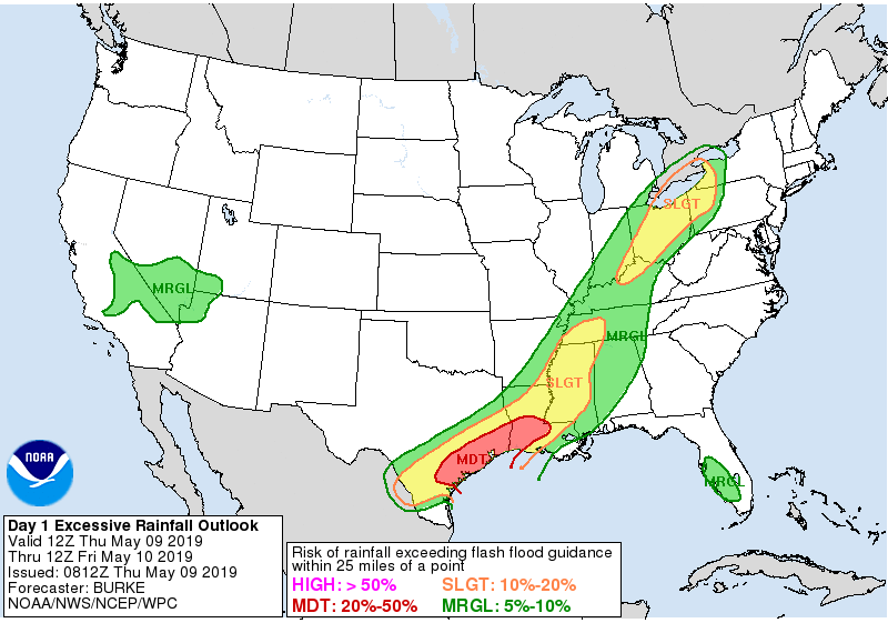
We will be under a moderate risk for excessive rainfall today from the National Weather Service’s Weather Prediction Center, meaning that there’s a good chance rainfall will lead to at least some flooding. Where, when, and how much is still TBD, but these storms late today will be capable of putting down at least 1 to 3 inches per hour. As we saw Tuesday, if they are slow enough, it can be more than that.
Also, any storms today could become strong to severe, and the majority of the region is in a “slight” risk for severe weather. Strong winds and hail are the primary concerns, with brief, isolated tornadoes not out of the question either.

Tonight
Storms will be ongoing to start tonight, and what could end up happening is that they could congeal into an organized cluster to the southwest of Houston and then plow across the entire region early in the overnight hours. If that happens, everyone will see another couple inches of rain or a bit more. Storms could try and temporarily wind down once that passes into the latter part of the overnight. If that does not happen, expect off and on storms and downpours to continue all night.
If you have evening or Thursday night plans, please have a way to stay informed and a dry place you can huddle up in if roads begin to flood. Nighttime is the most dangerous time for navigating flooding, so we urge you to not go out on the roads unless you’re absolutely certain you have a route that is not flooded.
How much rain falls today and tonight? Well, that is going to likely vary widely across the region.
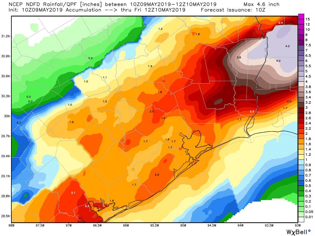
The map above suggests about 1 to 3 inches of rain on average by early Friday morning. It is a likelihood that some places will see much more than this. So consider this map just an “average” for now.
Friday
The exact details of what happens tomorrow remain up for some degree of debate. Sitting here this morning, I would call it “scattered” thunderstorms, especially in the morning, and I do think we will have a bit of a lull period at some point during the day Friday. But at some point, storms will re-fire and could again become strong to severe with torrential downpours.
Friday night through Saturday
The final round or rounds of this event will be Friday night into Saturday. Storms should explode Friday night in Central Texas and work their way slowly east toward our area. Periods of heavy rain and storms will likely impact the entire region during this time. We could be talking about a widespread additional 2 to 4 inches of rainfall, with higher amounts again possible.
All told, we should expect another 5 to 8 inches of rain between now and Saturday night, with isolated totals of 9 to 12 inches possible. Flooding should not happen everywhere, but it could happen anywhere, which is why it is important for us to remain aware of the forecast and what is happening over the next few days.
Sunday & beyond
Southeast Texas should dry out and clear out Sunday, with nice weather likely to continue Monday and Tuesday. We have been focused on the rain so much that we have not discussed much about cool, potentially comfortable weather for a few days early next week. It’s conceivable that some locations will start Monday morning in the 50s. So, despite the rain, we do have something to perhaps look forward to, unless you’re a fan of humidity. But then you have the upcoming 100+ days to enjoy. Our next rain chances likely return later next week.
Thank you so much for the clarity of the flood stage scale and this detailed update. I monitor 8 weather websites (mostly various NOAA sites), read all detailed forecasts and follow the models, but you put everything I’ve read into a great summary!
Your comments and explanations are so valuable to us!!! Thank you so much!
I have one serious question…should I cancel my team building activity at the sand volleyball bar in the Heights at 3:00 today, or just go ahead & risk it? I mean…we have T-shirt’s and everything…
My brother and family are planning to drive to Houston Friday from south Texas… should they cancel?
Your approach to weather forecasting is really appreciated! Very professional and honest, vs the stuff you get on tv. It’s refreshing….thanks😎👍. And BTW, your flood scale makes total sense.
Thank y’all so much for your hard work to keep us informed and ready!
Friday night- Astros AND Rockets home games.
Well, last time it happened Rockets won so….
It’s interesting because at 6:50AM Texas radar shows almost no showers in the entire state. We’ll see how these computer models work over the next few days.
850 mb relative humidity, water vapor imagery, and a quick look at the Lake Charles upper air sounding and a surface plot tells you that all the ingredients are in place.
And to think, here we were starting to get concerned about drought the past couple of months. Is this in the “careful what you wish for” category?
I live in Southeast Houston – Old Galveston and Edgebrook. How do I prepare for the weather?
Nothing. Carry on
Thank you Sandy. I’m just a little spooked from Harvey.
Clearing any debris (leaves, dirt, sticks, trash) from the street drains near your house is something you can do that could help drain water faster away from your street.
Thank you!
Like many I have things happening this weekend and I’m not sure how to proceed. I am supposed to attend a graduation at Texas A&M this evening and then on Saturday I was supposed to drive to Austin to catch a flight to London with friends in the evening. Should I forego the graduation and what day and time would be best for traveling to Austin. Should I try to get there tomorrow and just wait there with friends until Saturday evening? I feel lost and confused.
I am wondering about driving to College Station for graduation tonight as well (Thursday). We are leaving our infant with friends in our home but I’m worried we won’t be able to get back… Is College Station and the drive back down Highway 6 to Southwest Houston supposed to be problematic?
Highway 6 in Navasota, and 290 underpass at Prairie A&M are areas prone to flooding. Our son is graduating Saturday, so we are also trying to plan for the best time to drive up to College Station.
I need to drive to Austin on Friday night for a very special birthday present for my child. What advice do you have in terms of the best time to leave? I’m reluctant to take them out of school early for the trip, but is that the safest thing to do and leave around 2? We could technically miss part of the trip because the main event is Saturday night. Would you advise leaving Saturday morning instead? Thank you for any help you can provide. I would hate to miss making it to the special event.
You guys do an amazing job of predicting the weather! Thanks for all you do and keeping us informed.
Thank you Matt! I am realizing I have started to read more and more of this website and I am glad I’m doing so! you guys are awesome in more ways than one!
I am drop-jawed with amazement at many of the questions asked here. (I was going to do a parody but can’t even make stuff up that’s as good). You have the patience of saints…
🙂
I was going to ask if I should cancel my fence painting party on Saturday, but now I’ve been shamed into not asking. lol
I’ve done it before (asking precisely how much rain there will be in the NE corner of my lot between 3:51:29 AM and 3:59:03 AM), but it didn’t help.
Hahahaha!
We are planning to fly to Hawaii on Saturday morning at around 10:00 AM… we live in Katy and we fly out of Bush… is our vacation going to be cancelled?
Plans to drive to Dallas Friday morning from Sugarland. Would it be better to leave this afternoon? Or just stay put?
I love the Historic Examples on your Flood Scale! I understand that it does not indicate an exact repeat of the events cited in exactly the same area, but it does do what you intended – it gives me an idea of the magnitude of flooding that could happen anywhere during whatever current weather event we are looking at. I remember these historic examples (I guess that gives my age away somewhat!) and that really helps me understand the potential of the storms! As always, you guys are the best – please keep on doing what you do!
You guys really are the best. I really appreciate your hype-free, practical forecasts. And your detailed explanation of your scale. Thank you.
I know this may sound crazy but any reason to just leave town and wait until this whole thing is over?
Great weather coverage!
What amazes me that over many decades Houston and Harris county dont really know how to tackle the rain water in this bayou area. How to funnel all the rainwater out into the sea.
Bayous are rivers and rivers naturally or normally widen until they reach the sea.
When I look at the buffalo bayou for example, the bayou is just the opposite. It is narrow, so all the storm sewers that carry water to the bayou back up and bayou water comes into streets and houses.
Engineering knowledge is available to solve this.
Those naturally widening bayous also flood when there’s too much rain. Yes, you could engineer your way out of even a Harvey, but how much are you willing to pay in taxes and fees for that? Are you willing to have your house be one of the ones knocked down for a wider bayou, so the people upstream of you don’t flood? Are you willing to live in a city full of straight, concrete-lined giant ditches?
Engineering solutions must always be balanced with other considerations. Deciding where that balance is, that’s the thing we’re always debating.
“Probability of Rainfall Exceeding Flash Flood Guidance Within 25 miles of a Point” seems be pretty weak criteria for worry. 25 miles encompasses much of the Houston metropolitan area. Are there any finer statistics, e.g., “Probability of Rainfall Exceeding Flash Flood Guidance Within 5 miles of a Point”?
Congrats on the Washington Post coverage!
I love the Flood Scale with the historical references. Your explanation is clear, but depends on people’s accurate recollection of what those events were. I remember them all pretty clearly. Even if I did not, the ‘expected impact’ provides a helpful quick guide. Thanks for working on this and putting it out.
Amazing how even after these guys provide you all of this detail and all of the caveats, so many continue to fill the comments sections with requests for special personal weather advice in order to guide their personal decisions regarding intricate details of their personal lives…
Hey Space City Weather – I have my great uncle’s wedding on the shore of Lake Conroe tomorrow at lunch, followed by a flight out of Hobby 3 hours later to Cabo, but I need to wait for my cousins to drive in from Lake Charles first, but there’s rain and a gray cloud, and WHAT SHOULD I DO???!!! WHAT SHOULD I TELL EVERYONE?!?!?!
Thanks for coming up with this. I’ve been fighting the urge all afternoon.
I think Eric and Matt have a good policy (so it seems) of not replying to overly detailed personal requests which they realistically can’t have input on. I guess people for some reason can’t handle the concept of uncertainty in a forecast anymore. You have to go with what nature gives you.
I have a flight out of IAH early Friday morning at 6 am and back in Houston around 9 pm that night. Is this going to be problematic?
I really appreciate how you break down the presentation of your analysis by day / time of day. It really helps the people who are thinking about the forecast in terms of their own personal plans, even if the update for their time frame is “we don’t know right now.” Keep up the great work.
The Memorial Day 2015 flood you refer to in the Stage 3 scale…I was involved in the flood relief and thought that happened Memorial Day 2016 soon after the Tax Day flood?
There were two Memorial Day flood events – 2015 and 2016. Depending on where you live, one was worse than the other. For me, 2015 was ok, I did not flood, but in 2016, I had 5 feet of water. This is why they have flood scale explanation in the beginning of the post – I was confused too! If I merely use the historic example, Stage 2 is worse than Stage 3 for me……but, logically, that wouldn’t make sense.
My dog is turning 5 tomorrow, and 15 others (dogs and cats mostly, and one ferret) already RSVP’d. Do I cancel or just have the party inside?
Depends, will it be raining cats and dogs?
Score one point for Hola.
Update from other meteorologists:
The weather forecast begins with heavy rain starting today around 4 – 5 p.m. on the west side of the Houston metro area (Richmond and Rosenberg). We expect the storms to expand from the west (Ft. Bend, Brazoria and Harris counties) through northeast Houston, with anticipated rainfall rates of 2 – 3 inches per hour. These will be slow moving storms; from 6 p.m. today until 4 a.m. Friday they will remain persistent.
Inside the 610 Loop, rainfall amounts can be expected to range from 4 – 6 inches, with localized amounts of up to 8 inches. South and west of downtown, upwards of 12 inches of rain can be expected. The severe weather is anticipated to include high winds, hail and lightning.
Time to evacuate to Katy again.
Yeah, I would like a better explanation on why are supposed to expect this rain. A few maps of the conditions that are going to collide for this big storm to pop up today out of nowhere.
Slow moving cold front draped across TX, moving towards the area, projected to stall somewhere around I-10 to coast. Google “US surface map with fronts” and you can find many that depict the front. Links aren’t posted here without review. Also, go to the Houston NWS page and look at “Satellite”, then look at low level water vapor imagery loop. This shows a very robust transport of moisture into the area and is associated with a low level jet that will help enhance storm production. Finally, go read the Houston/Galveston NWS afternoon area forecast discussion (AFD) that comes out, usually between 3:30-4:00 local time. While technical in nature, it will provide some insight into the mechanisms and parameters in place for precip over the next day or two.