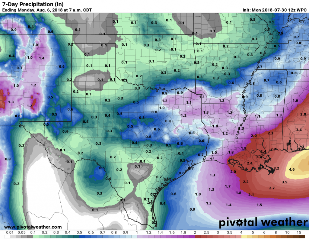
Houston’s high temperature has reached 100 degrees four times during the last eight days, which almost meets our “normal” quota for the total number of these days during a calendar year. Now, fortunately, we’ll take a slight step back this week with the heat, and also return some welcome rain chances to the forecast. Not everyone will get rain this week (sorry), but I expect most of the region to pick up between 0.25 and 0.75 inch of rain between now and next time this week. This should also help with African dust levels, as discussed below.
Monday
This will be another warm day for Houston, with high temperatures in the upper 90s, and clear skies this morning. However, some clouds should work their way into our skies this afternoon, and the eastern side of the city will see some moderate rain chances—perhaps 20 to 30 percent as some storms moved into the region from Louisiana. At the same time, a weak cold front will be moving down the north of the state, and this will bring some additional instability into the area, and portend better rain chances on Tuesday.
Tuesday
For the first time in what seems like weeks, skies should be mostly cloudy rather than mostly sunny. This, alone, should help keep high temperatures in the low 90s. Conditions aren’t perfect for rainfall, but the stalling front combined with surface moisture should be enough to generate some showers and thunderstorms for parts of the region. Again, accumulations won’t be too significant, but after a dry spell during the second half of July anything will be welcome.

Wednesday, Thursday, and Friday
Mostly sunny skies return for the second half of the work week, and we can generally expect high temperatures in the mid-90s, with nighttime temperatures in the mid- to upper-70s. This will feel slightly better than what we experienced during the second half of July.
Saturday and Sunday
Medium-range forecast models indicate that an upper-level disturbance or two will move into the region this weekend. This should bring some clouds back for the weekend (although we’ll still see some sunshine), and probably some scattered showers and thunderstorms. For this reason we can probably expect highs to drop down a tad, into the lower 90s. Rain chances will be hit or miss, so I wouldn’t cancel those outdoor plans just yet. We’ll do our best to refine the forecast as the weekend nears.
Dust update
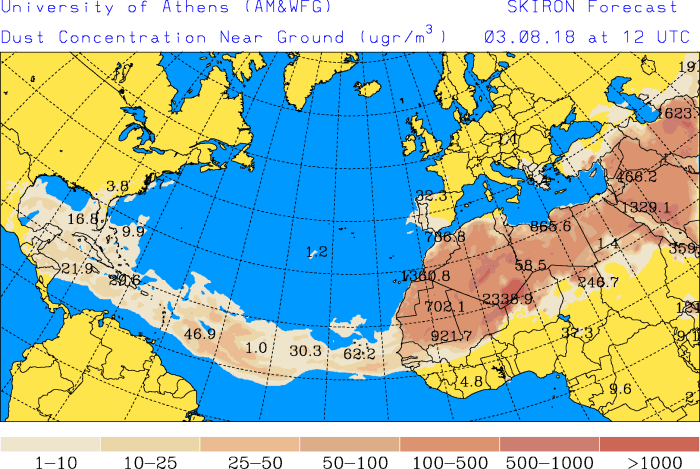
We’ve received several questions about African dust, which is playing havoc with allergies. Forecast models suggest low-levels of dust will remain for the next few days, but levels should fall to near zero by Thursday or Friday. Widespread rain Tuesday would certainly help with this.
AM or PM rain on Tuesday? Wanting to do yard work early Tuesday if possible. Will do it today if I have to. House guests arriving Wednesday. Thanks for any clarification.
Check this out:
https://forecast.weather.gov/MapClick.php?lat=30&lon=-95.37&unit=0&lg=english&FcstType=graphical
Looks like a 43%-46% chance of rain 7AM-6PM Tuesday but not very much rain is expected.
https://forecast.weather.gov/MapClick.php?lat=29.7606&lon=-95.3697&unit=0&lg=english&FcstType=graphical – Looks like the chance increases slightly from ~45% to ~50% from the morning to afternoon. There is a higher accum. amount possible in the morning and possible rain tonight and early morning tomorrow.
Probably more likely during the afternoon or evening.
YES!! A reprieve from the heat!!! Yesterday, at 102 degrees was NOT a good day to lose A/C in the car!! Ugh!!!
Cool dust map. Also the map made me realize that Houston is almost exactly the same latitude as the pyramids of Giza.
Wait, if the outside temperature falls from the upper to lower 90s, doesn’t that mean my office will be even colder than the 65F it reached on Friday???
Currently have drizzle around Ellington with thunder towards the northwest.
So excited hearing thunder! Bring on some rain!