Houston’s dreary pattern will continue for a few more days, especially over coastal areas, in the absence of high pressure to shut off rainfall. Our biggest concern lies well to the southwest of Houston, where several inches of rain have already fallen near Matagorda Bay. These areas are likely to see the potential for the heaviest rainfall again today and Thursday, raising our flooding concerns.
Wednesday
The overall pattern remains, with a broad upper-level low pressure system over coastal Texas that is helping to rain moisture down upon the Gulf, and parts of the state near the Gulf of Mexico. Showers are largely confined to coastal areas this morning, but models indicate they will push further inland later today, with areas north of Interstate 10 seeing at least a scattered chance of rainfall this afternoon.
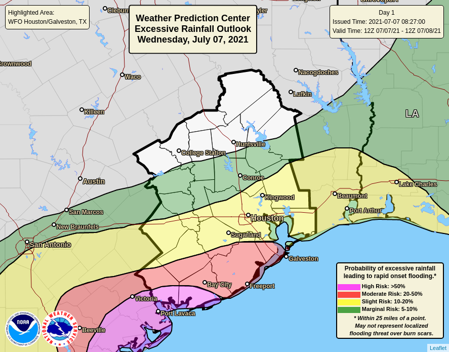
For the Houston region, accumulations will likely be 1 to 3 inches right along the coast, with higher isolated amounts, and less than 1 inch for most inland areas north of Interstate 10. The map below, from NOAA’s Weather Prediction Center, shows the area along the upper Texas coast most at risk for heavy rainfall later today. Matagorda Bay could see 2 to 4 inches of rain, with higher isolated totals. Due to clouds and rain, highs today will likely be in the low- to mid-80s for much of our area.

Thursday
This will be another wet day, quite possibly a repeat of Wednesday in terms of rains and temperatures, with heavy rainfall along the coast, and especially southwest of Houston near Matagorda Bay. After all of this accumulating rain, areas such as Port Lavaca and Victoria could definitely see the potential for flooding, which is something to consider if your travels take you southwest of Houston, along the Highway 59 corridor.
Friday and Saturday
As the low-pressure system begins to depart the potential for heavy rainfall should start to diminish some, but both of these days should see the potential for widespread, intermittent showers. Skies will otherwise be mostly cloudy, with highs in the upper 80s to 90 degrees for most. Have a backup plan for any outdoor activities on Saturday.
Sunday and beyond
Sunday should bring the return of at least some sunshine to the region, although we’re probably not talking full-on blue skies. Beginning Sunday, and into early next week, we should see a more summer-like pattern, with highs in the low 90s, and a 20 or 30 percent chance of a passing shower during the afternoon due to heating and the sea breeze.

Tropics
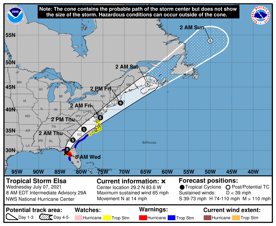
Tropical Storm Elsa is approaching the coastal bend of Florida this morning with 65 mph sustained winds. After landfall today it will cross the southeastern United States, likely maintaining tropical storm-strength winds before reemerging into the Atlantic just off the eastern shore of the United States. It could bring messy conditions up the eastern seaboard on Thursday and Friday as it accelerates to the northeast. After Elsa, the Atlantic tropics should remain mercifully quiet for at least the next week or so.
Love your updates as always. But is that graphic for excessive rainfall from yesterday (Tuesday) instead of today?
What do you think Saturday will be like in Conroe around midday? My son is having a pool party for his birthday, and I’m really hoping for no thunder. A little rain never hurt anyone, I’m just not wanting to lose pool time waiting on a thunder warning. Thanks!!
About a week of temperatures below 90 in JULY. If I see you guys, I’m gonna kiss you!
Can you do the same in August?
Thanks as always for excellent weather reporting. I’m curious how June turned out on the averages – above or below for temp, rain, etc. This summer – really this whole year – is curious!
The NWS feed on the iPhone app does not appear to be working
UGH I can’t deal with this humidity for much longer. Too much PTSD from horrible storms I’ve been through; even an inch makes me crazy. Granted, it’s nice to not have it 98F, but…. sigh. Insert mushroom emojis here. 😉
Thanks. I was just outside with the dog and thought “75? On July 7 at 930?” While the pooch and I are tired of the rain — well, I’m tired of cleaning his paws — the fact that my AC has run about a third as much as usual and I won’t have to water until closer to the end of next week…I’ll take it.
What happened to the rain today?
On another note, this low over south Texas is beginning to look a bit tropical to me, especially that rainband by Corpus Christi. Is there a chance the low could move over the Gulf and develop tropically?
Wondering the same thing here. Watching the radar from the Corpus/Freeport area this afternoon gave me flashbacks.
Is there a storm brewing off Corpus Christi? On my weather app looks like a bit of rotation going on.