September has been a wet mess for most of Houston, but the one upside has been temperatures. At a time when we typically see highs in the mid-90s, the last three days have generally produced highs in the 80s. And if you like this wet, slightly cooler than normal pattern have we got a deal for you. Because this rain-lovers-delight pattern should continue for quite awhile.
Wednesday and Thursday
These days should be drier than the recent weather in Houston, but only in the sense that showers and thunderstorms should be more of a scattered nature rather than widespread. Even so, we expect 30 to 50 percent of the region to see some form of rain the next two days. Highs will depend upon shower activity, and likely will range from the upper 80s to the lower 90s. Sunshine will be scarce, but we can probably reasonably hope for a few breaks in the clouds.
Friday, Saturday, and Sunday
As whatever is left of Tropical Storm Gordon moves well north of Houston, toward Oklahoma, it will leave lower pressures in its wake for our region. This will lead to, again, a healthy chance of rain showers through the weekend, probably around 60 percent each day, give or take. This should keep highs in the 80s or low 90s, and unfortunately we’re going to hold onto those mostly cloudy skies. If you’re planning outdoor activities, uhhh, have a back-up plan.

Next week
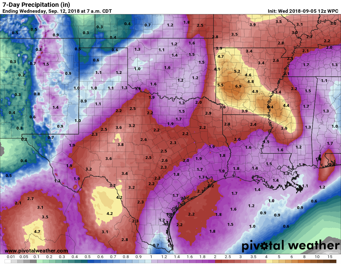
Alas, the models are generally in agreement about moisture levels remaining high through at least the early part of next week, which should lead to more on-again, off-again showers and thunderstorms. Overall, the models don’t indicate anything too extreme in terms of overall rainfall, but it’s probably safe to expect that most of the region will pick up an additional 1 to 4 inches over the next week or 10 days.
Tropics
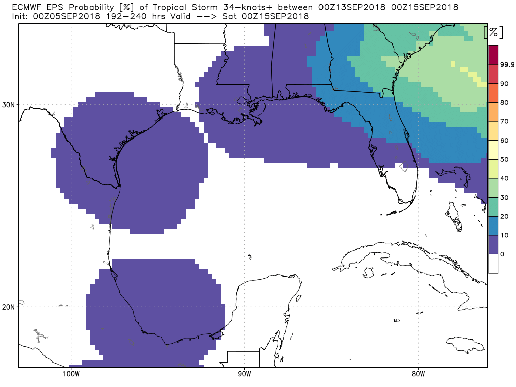
The Atlantic remains quite busy, with the remnants of Gordon now inland, Hurricane Florence in the open ocean, and more storms coming behind. In terms of the Gulf of Mexico, we’re not tracking anything specific, and the European model predicts a 10 percent or less chance of a tropical storm forming in the region during the next 10 days.
For early September, that’s pretty good.
I’m grateful!
What’s that magical date in Houston where it seems we are typically a out of harms way from a major storm?
I would love to see this info as well.
Typically Oct 1st or so
Typically that happens with the first major cold front. That normally happens sometime in the next 2-3 weeks, iirc.
I think the average first cold front shows up around September 26th, plus or minus several weeks. Once the fronts start showing up the storms can’t make it across the GOM. In fact Ike was kicked out of Houston by a front, if the front had been a day sooner ike would have missed.
Eric says the magic date is: September 24!
https://spacecityweather.com/texas-hurricane-season-over-2016/
Probably in about a billion years, when the sun starts to expand to a red giant and incinerates the earth. No need to worry about storms then!
Ummm, is anyone reading between the lines here? There might only be approximately 10% chance in the Gulf, but I noticed nothing was said about those tropical waves moving off the coast…heading west.
Those waves may well end up in the Atlantic or washing out, don’t make something of nothing, nobody is trying to pull a fast one.
check out the EURO and GFS model (I know they are way way in advance) but has a huge Cane hitting Carolina around 12th-14th, a Cane hitting Florida around 20th and storm hitting Texas Valley/Coastal Bend around 16th-20th…. Predictions I know, but I would like Eric or Matt to chime in with how likely..
Those model solutions are unlikely to verify as shown…there’s a lot to track but there is absolutely no way we can tell you much more than “there’s going to be stuff out there” for the next couple weeks. Once within 5-7 days of a threat, we can start saying more.
THANK YOU! Since Harvey (house destroyed) I have gotten more interested in the science behind weather. I thank you for clarification and answering my questions, which I could not really find any answers.
As is usually the case in September, there are a lot of things to watch. Unfortunately, the state of the science doesn’t allow for reliable tropical predictions more than 5-7 days in advance. Some of that stuff off Africa may be 2+ weeks away still if it even came this way. There’s not much between the lines here…we’re watching, we’re vigilant, and we’ve got nothing right now that says we need to really be worried about anything.
I’ve seen some alarmist articles predicting a very cold winter in general. Is there anything reliable yet to support these contentions?
No sir. Not yet. There is definitely a chance it could be a colder winter, but in terms of anything reliable saying “gloom and doom,” there’s nothing out there.
I grew up in Wisconsin, went to college in Nebraska. I detest cold and snow with a passion. While my girls were excited to see snow this past winter, I was on the verge of tears. I don’t know what I’d do if it was super cold and snowy for even a day again this year.
My wife sometimes longs for those “beautiful snowfalls” we used to experience when we lived near the Great Lakes. That’s when I pull out the videos of wind driven snow blowing sideways and the plow coming down the street and leaving a huge pile of ice/snow at the end of the driveway while taking down our mailbox.Beauty is truly in the eye of the beholder!
Last year, your blog helped me keep my sanity – that’s no exaggeration. I appreciate your candid and no-junk presentation. I’d had a friend steer me to you years before 2107 and I never listened. Since Harvey, you guys are my weather “bible” – thank you for what you do.
Thank you so much, Tara. Referrals to friends and family are the highest compliment we can receive.