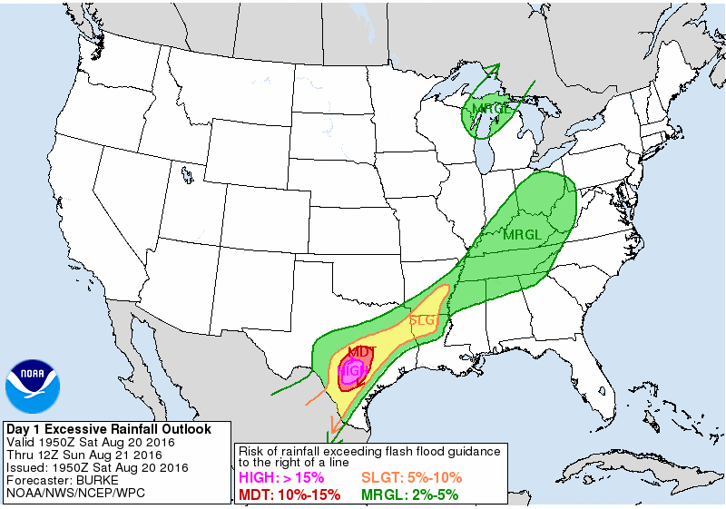
It has been a partly to mostly sunny day for much of the Houston with a few rain showers developing across the city. But the second half of the weekend and into Monday looks notably wetter.
Saturday night
For tonight heavy rain will remain to the west of Houston, most concentrated over the Hill Country. A stalling cold front along with ample moisture will set the table for potentially flooding rains in the San Antonio and Austin areas. Forecast models support the idea of some areas receiving in excess of 10 inches of rain between Saturday morning and Sunday night.

The central Houston area is unlikely to see much effect from these storms tonight. However northern and western counties of the region—Houston, Madison, Brazos, Burleson, Washington, Austin, and Colorado—have been placed under a flash flood watch as a precautionary measure.
Sunday and Monday
Higher moisture levels move into Houston by Sunday morning and will hang around through Monday. I’m not expecting a total washout, but the region could easily pick up another 1 to 3 inches of rain, with higher isolated totals. It shouldn’t cause widespread flooding, but rather be like some of the wet days Houston had last week. I’m hoping the rain showers won’t be too bad on Monday morning, when much of the region returns to school.
Also, if you’ve enjoyed the cooler weather, with highs in the upper 80s to 90 degrees, you’ve got a few more days to look forward to.
Tuesday and beyond
Some higher pressure will work its way into the region, likely reducing rain chances to the “slight” category, and primarily during the warmer afternoon hours. High temperatures should climb back into the low 90s. It will be warmer, but certainly not anything like the worst that August can throw at us. If you’re tired of the rain we’ve had during the last week—you’re going to get at least a few drier days.
Radar in Ft Bend looks menacing at 2220,,,no rain yet though