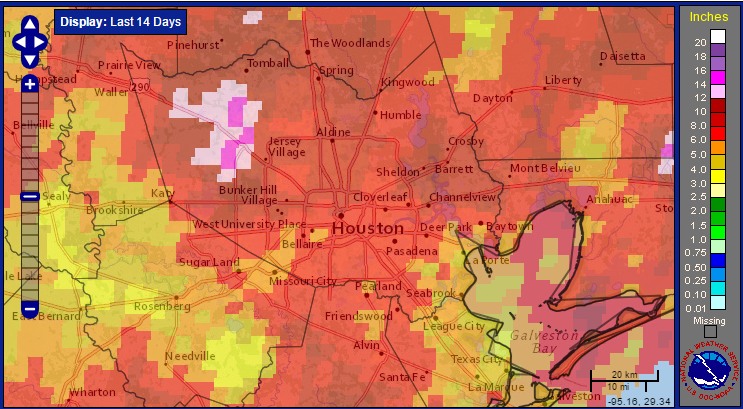
It has been quite a different middle of August for the greater Houston region. During the last eight days the high temperature has stayed in the 80s for six of those days, with a maximum of 92 degrees. And the rain. We’ve had lots of it. The greater Houston metro area has recorded 4 to 16 inches of rain during the last two weeks—an uncharacteristically wet spell for the dead of summer.
Here’s a rainfall accumulation map for the last 14 days:
We’re now going to enter a slightly drier pattern, but we’re not going back into deep summer like the conditions we experienced at the beginning of the month.
Today
Back to school for most kids! The day is starting out with some patchy fog over parts of Houston, but that should burn off by around 8am CT or so. Although atmospheric moisture levels are lower today than Sunday, there’s still enough hanging around to generate some showers and thunderstorms later this afternoon, so be mindful of that when school lets out. Highs today should be in the upper 80s to low 90s.
Tuesday and Wednesday
Pressures should rise a little beginning later on Monday, which should limit—but won’t shut down entirely—rain chances on Tuesday and Wednesday. Expect partly to mostly sunny days, with highs in the low- to mid-90s, and some scattered afternoon showers due to daytime heating.
Thursday and Friday
After a couple of somewhat drier days, moisture levels rise again during the latter part of the work week. This should lead to better rain chances and coverage during the daytime, but I’m not expecting a washout. Most areas likely will see tenths of inches of rain, rather than inches. The increased clouds should help to keep highs to about 90 degrees, or below.
Saturday and Sunday
Scattered showers remain possible next weekend, with highs around 90 degrees or so. I’m not expecting next weekend to be quite so wet as the one we just completed, however. There should be enough cloud cover to let our rather “mild” mid-August continue.
Tropics
We’ll have a full report on the tropics later today. While nothing looks to imminently affect the Gulf of Mexico, things sure are likely to get busy in the Atlantic.
Posted at 6:45am CT on Monday by Eric
Sounds like we’re probably done with 100’s with fronts already getting here, thank goodness! it was a scary few weeks of blistering heat, but all in all not too bad for Houston.
Eric, I have not heard anyone talking about the huge amounts of rainfall the Gulf Coast has gotten the past few years. I am in Alvin, and we had close to 100 inches of rain the past year, and abnormally high raibfall, ever since the drought ended, it seems. We have a hirse farm, and our property that didn’t flood, even in 1979, has had standing water most of the past year. We’ve lived here since 2002, and I gate to think this is the new nirmal. 12 inches of rain the past 10 days. Are we in some sort of super El Nino? Any explanation for the continued record setting rain???? P.S. I am a former Chronicle person too, 21 years. Thanks Cyndi Craig
Some of the rainfall is due to La Nina, which made for a wetter late winter and early spring. I do not think this is the new normal (and ENSO conditions have reverted back to normal), rather I think it’s just a wetter than normal year.