As Eric has been conveying, this weekend is not going to be the most optimal for the Houston area. We’ve got rain chances in abundance. Thankfully, we don’t anticipate any serious problems from the rain, but if you have outdoor plans this weekend, you may need some alternative options. Let’s walk through it.
Today
Yesterday saw a good bit of rain mostly south of the metro area, down toward Wharton and Angleton and west toward Brookshire, with a few storms here and there elsewhere.So far, quiet this morning, with just a few showers down in Matagorda County. As the day goes on, I would expect scattered showers and storms to fire up with daytime heating, beginning at the coast and spreading inland. Not everyone will see rain, but those that do could pick up a quick half-inch to inch of rain in a cooling downpour.
Expect highs near 90°, but a little cooler if it happens to rain a bit more at your location.
Weekend & Monday
So, let’s start with this: I don’t think this weekend will be a complete washout. If you have outdoor plans, I might not completely abandon them. But I would absolutely have an alternative in place. I think Saturday may be a better day than Sunday, unless you live northwest of Houston. It won’t rain all the time and everywhere this weekend, but where it does rain, it may be heavy at times with some patchy street flooding possible.
Who are we expecting to see the most rain on which day? There will be a weak cold front draped inland over Texas. No, it won’t usher in cool, dry air, but it will act as a focal point for the rains. On Saturday it may be well north and west of the city, out toward Columbus and north to College Station and over into Walker or Madison Counties. By Sunday, it creeps closer to Houston.
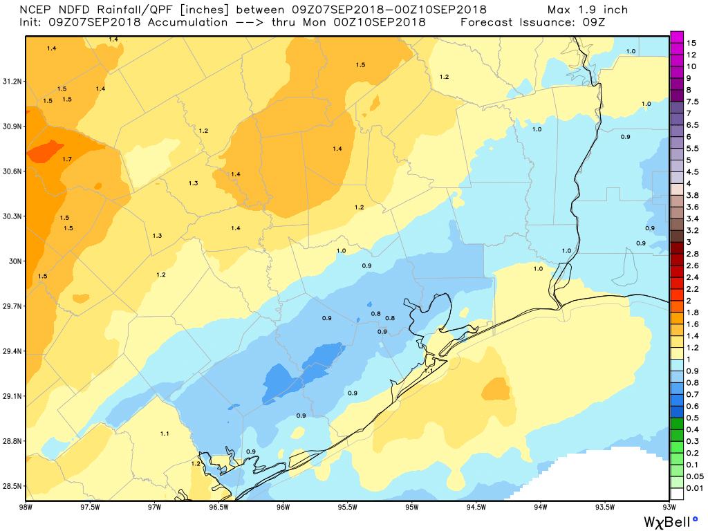
I still think the focus of showers on Sunday may be to the northwest of Houston, but perhaps out toward Katy and up to The Woodlands and toward Livingston, so a bit closer. So it’s conceivable that both days, the majority of the rainfall stays northwest of the Houston area. We’ll still see some scattered showers and storms regardless though.
On Monday that front may creep through the area while falling apart. So, again, scattered to numerous showers and storms with daytime heating, now across the Houston area. Look for temperatures to top off in the upper-80s most days on average (90+ if you don’t see rain, cooler if you see a good deal of it), with lows in the mid-70s.

Tuesday & Wednesday
The really high amounts of atmospheric moisture that will be over us this weekend will begin to temporarily ease up a little midweek next week. They don’t drop off enough to remove a chance of daily showers and storms, but the coverage should drop off a bit from where it has been, at least for a day or two. But most days through next weekend will carry some degree of rain chances. Look for high temperatures to average near 90 degrees, again, cooler with showers, or lower 90s with no showers.
Tropics
Lots of boxes to check off here, so let’s run through things. Here’s the quick and dirty, then we’ll cover more details
- The system we are watching with most interest for Texas is labeled “Invest 92L” deep in the Atlantic. If we even see impacts at all, they are at least 12 days away, so we aren’t worrying about this right now, just monitoring.
- The system labeled “Invest 93L” behind it is expected to stay out at sea.
- Depending on which disturbance forms first, they will take on either the name Helene or Isaac.
- We are watching the Yucatan/Bay of Campeche area late next week for a possible weak disturbance, but as of right now, there is no signal that this would be serious. Again, just babysitting.
- Florence is back to a tropical storm this morning. It is not a concern to us in Texas right now, but it is something for folks on the East Coast to begin to think seriously about.
Now, some details. Invest 92L this morning is sitting a few hundred miles west of the Cabo Verde Islands. It’s tracking to the west, not especially well organized, but very close to becoming a tropical depression. 92L isn’t in a hurry to come west, and it will move slowly but steadily over the coming days. It is the disturbance of most interest because it’s likely to continue to track west toward the Caribbean through next week. Once there, it has a plethora of options at its disposal, including a track into Central America, a lurch northwest into the Gulf, a right turn toward Florida or the Bahamas, dissipation, or just out to sea.
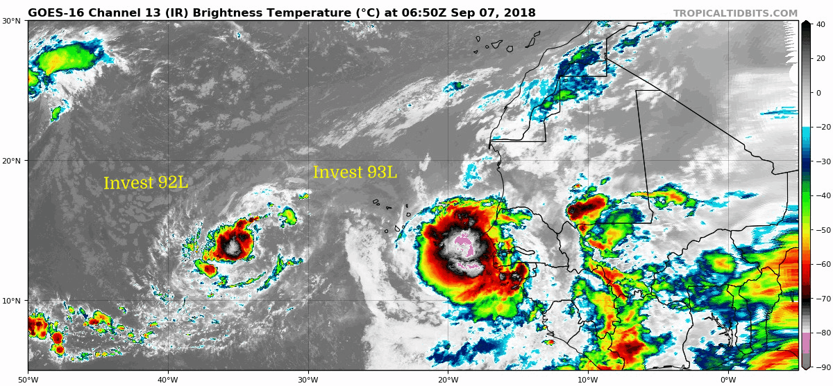
Frustrating as it may be to hear, we really have no idea where 92L ends up. We do know that if it somehow got over all the hurdles it had to and ended up in the Gulf, it would be just under 2 weeks from today. It’s a long, long way away so there’s nothing to worry over here right now, but we will want to monitor its progress in the days ahead. When will we know if it’s a serious risk? Not until sometime early to midweek next week — at the earliest.
Behind Invest 92L is Invest 93L. Modeling is in good agreement that this one will develop with a little more voracity, which should allow it to gain latitude fairly fast and stay out at sea. We’ll keep tabs on it however.
We will want to also keep tabs on the Yucatan area next week for a potential disturbance that could briefly develop. I don’t think this is a serious risk to worry about, but it would be late next week, so again, we’ll watch it closely.
Then we have Florence. While Florence isn’t a concern for the Gulf right now, it is the most imminent storm on the board. Though it was a category 4 hurricane less than 48 hours ago, it succumbed to wind shear and has weakened back to a tropical storm.
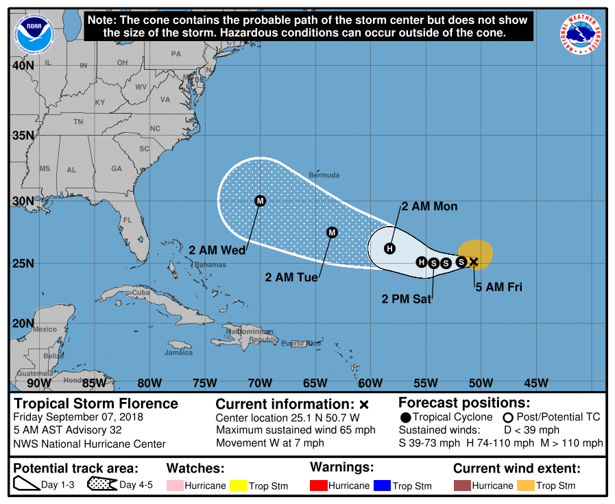
Florence will likely hit warmer water and less shear in the coming days, allowing it to reacquire hurricane intensity, eventually major hurricane intensity also.
Where does Florence go? If you can answer that, you’re doing well for yourself. Florence will be steered around an extremely strange looking weather pattern in the upper atmosphere. Every single time in recorded history (since the mid-1800s that we know of) that a storm has been located near where Florence is, it has curved out to sea. The pattern that is setting up is one that will force Florence back to the south and west, block the exit route, and allow it to at least threaten the Southeast, Mid-Atlantic, or even New England. How close it comes and to whom is the million dollar question, and though weather modeling has increasingly started bringing it toward anywhere between the Carolinas and New England, it is absolutely impossible to tell you the end game here. It could still go out to sea, but it’s getting more difficult for it to do so without having some impacts somewhere on the East Coast. Suffice to say, folks along the entire East Coast should be monitoring Florence closely.
We will refresh this on Monday morning for you, unless something serious changes this weekend.
The best and only source for weather forecast and current conditions our family has available. Thank you for your knowledgeable insight and efforts.
Have been following since before Ike… as usual, that’s so much for all of the detailed info and none of the drama!
Which radar app do you recommend? Since you don’t have one. That imI aware of.
RadarScope
I second the Radarscope recommendation, but for the average user, it may have too many bells and whistles (and it costs $10). I haven’t found a great app otherwise. I would experiment with some of the local TV station apps truthfully for radar, and if not, try WUnderground, which is a good utility weather app.
I used to love Weather Underground. And I used to hang out on Dr. Masters’ blog during hurricane season. But the last few years it seems to have gone downhill. But, yeah, their radar is pretty good still.
They were bought by the Weather Channel
I know
Wonder why there is no reality programming on wunderground then.
Then I’m wondering why there is no reality programming on Wunderground. Like Cantore getting sucked up a tornado or something.
One of the best free radar apps is RadarNow!. It is a simple radar app (not a full weather app), but it grabs new radar updates more quickly that most free radar apps and loads up very fast. It doesn’t have a lot of bells and whistles, but it is my go to for a quick radar look.
You can tweak the radar switch interval (animation speed) and transparency of the layers to make it look how you want. Zooming out gives you a combined radar, but zooming in lets you look at the local radar
I like MyRadar. It has a free version that can be upgraded to ad-free if you like.
I agree with Robin. MyRadar is a great app.
I use MyRadar Pro and haven’t had any issues with it other than for a while the widget in my control screen was set to Celsius for some reason, but that went away. Everything else is awesome.
I know this is a few days old, but MyRadar (along with NOAA Weather Radar) was listed today as one of about a dozen apps that have been discovered to be surreptitiously transmitting your location data to advertisers. (Source @ ars)
Eric and Matt need to create their own “no hype” app. That would be amazing!
Any idea how much rain there’s going to be College Station tomorrow for tailgate and the game?
Vegas says it will be raining Clemson TDs to the tune of a 12.5 point dog for A&M.
I’m looking for an upset
FIFY: I’m looking for upset.
I’m looking at Aggie fans who will be very upset after this game
I don’t expect a win. Jimbo needs at least two cycles of recruiting classes to undo Sumlin’s damage
I would anticipate that any showers could dump a quick quarter to half inch or more. But the majority of the heaviest stuff may stay NW of CS tomorrow evening and may actually dissipate too. But I would prepare as if it were to rain just to be safe.
As luck would have it, I am traveling to North Carolina next week. I am already planning on possibly having my flight home delayed or even canceled. or awhile, I thought I might be traveling from Gordon to Florence. At least that didn’t pan out.
So, I have a major event on Sunday down on the Bay – La Porte/Shore Acres – we’re supposed to be having a “tropical” day of swimming and fun….. what’s our chances of out door activities in my area? Other than that, just more good sleeping weather!! LOL
Upcoming cold front predictions? Not so many long-range surface maps to refer to anymore
Wasn’t hurricane Ike in nearly the same location about 10 days before it hit Houston?
Ike was actually much further north, and it is a rarity for a storm that far east/north to make it to Houston!
I read that there is some disturbed weather currently over the Caribbean Sea that is being monitored for the possiblity of sneaking into the Gulf …According to the article, this tropical weather has some potential for developing and impacting Texas next week…Saw the article today on ABC 13 website..Can anybody shed more light on this? I will be doing some longer distance travel in Texas at the end of the week…
Our latest on this has just been published: https://spacecityweather.com/locally-heavy-rain-houston-early-week-watching-late-week-tropical-wave/
I have a question for Matt & Eric: who gets to name the storms? I know they go in alphabetical order each year, but who actually has the job of picking the names??
The World Meteorological Organization has that duty. You can find out more here! https://oceanservice.noaa.gov/facts/storm-names.html
And here I moved halfway across the country to the Carolinas to the mountains to get away from hurricanes. Unless they start magically smacking into Colorado, I guess that’s the next planned move.
So, here I am back at SCW.