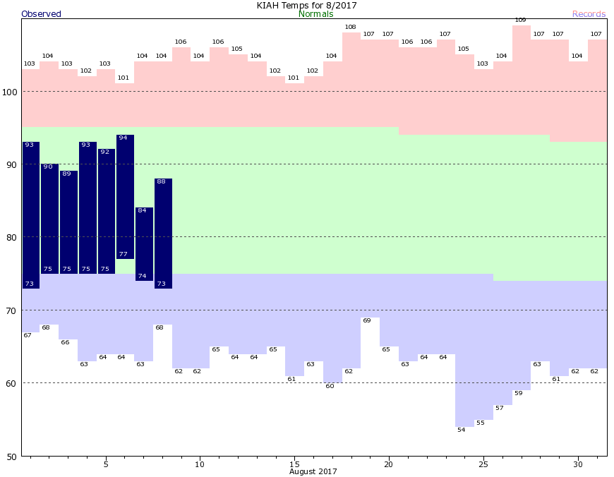
The National Weather Service has allowed the flash flood watch to expire for the entire Houston region, with the exception of Galveston and Chambers counties. Even for these areas, showers are dying out, and we should no longer face any kind of widespread, heavy rainfall threat. It has certainly been an atypical August so far, with the absence of high pressure allowing for lots of rainfall. Another benefit has been cooler weather. The first two weeks of August are typically the hottest time of year for our region, and we’ve been blessed with highs about five degrees below normal. Here’s what it’s been like at Bush Intercontinental Airport so far.
However, as you might suspect, this isn’t going to last. As pressures rise heading into this weekend, temperatures will follow.
Wednesday
The lower pressure system in the mid-levels of the atmosphere has slid off to the east. This means there is no real impetus for widespread, heavy rainfall across the Houston area today. However, atmospheric moisture levels remain high, so we’ll definitely see at least some scattered showers today—with better chances to the east of Interstate 45—and likely some isolated downpours. Fortunately, they should be relatively short lived. Highs will be around 90 degrees.

Thursday
Conditions will be similar to Wednesday, but skies will probably be a little more sunny, and therefore I’d expect temperatures to kick up into the low 90s.
Friday through Sunday
Higher pressure will begin to exert its influence on the region, although this is unlikely to be a suffocating high pressure system like we see during most Augusts. Still, highs will kick up into the mid-90s under partly to mostly sunny skies. We can’t rule out rain chances for the weekend, but showers should be isolated to scattered, occurring during the afternoon or evening hours. Outdoor plans should be good to go this weekend—if hot. This more typically August-like weather seems likely to persist well into next week.
Tropics
Tropical Storm Franklin is nearing hurricane strength in the southern Gulf of Mexico, but it’s going to stay well south of Texas as it follows a westward track. Inland flooding is a concern for Mexico from Tampico south. Out in the Atlantic another system may form as it nears the Bahamas this weekend, but it appears likely to curve north before threatening Florida or the US East Coast.
Posted at 7:05am CT on Wednesday by Eric
🙂 Well at least the week of lower temps I “brought back as promised from the Pac NW” gave us some relief. Someone else must have returned from the deserts of Egypt and brought the heat with them. 🙂
Yes, Chuck. Next please visit Iceland and return for the second half of the month.
Well Eric, I could do that, but that would also risk bringing back a volcano.
Hurricanes I can deal with. Been thru several tornado warnings (no damage) in Tulsa. Been thru floods (no damage). Been thru an earthquake in CA (not recommended). I’ll limit myself to the windstorm and high water stuff — we can get out of the way of those!
In a week or so it may feel like we’re living in the caldera of a volcano.
You two are a welcome breath of fresh air!
North Pole. No volcanoes there.
Eric, what do you think of the new hurricane forecasts where the team at Colorado State now thinks there will be more storms because the El Nino failed to form?
Regardless of seasonal forecasts, which are not particularly meaningful at this point, Texas needs to be really concerned about the potential for hurricanes to form during the next six to seven weeks. We are at the peak of the season for our region. Fortunately, nothing is imminent.