In brief: A dying front brings a chance of storms well to the north of Houston tonight, but for most of us the story remains one of heat. Temperatures will peak over the weekend, with Memorial Day looking especially hot.
Wednesday
Expect another warm day in Houston, with highs of around 90 degrees due to mostly cloudy skies. It will be a little windier than Tuesday, with southeasterly gusts up to about 20 mph. With the humidity, it will feel plenty hot outside during the daytime hours before lows drop to about 80 degrees tonight.
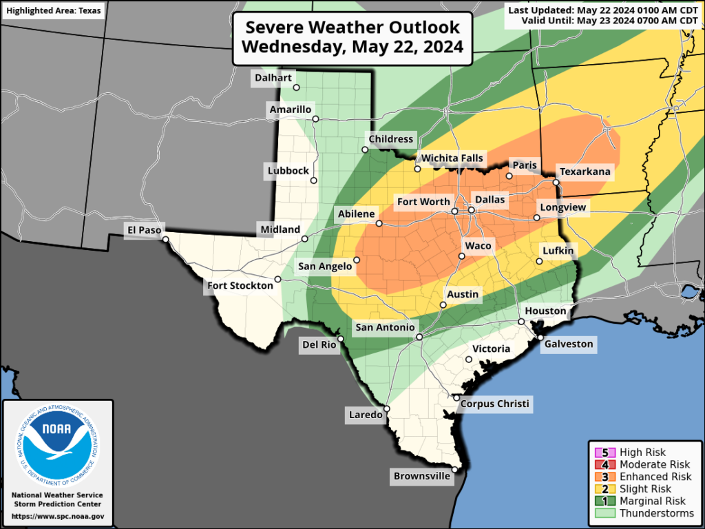
For areas north of Houston, and by this we are probably talking about locations north of Highway 105 in Montgomery County, there is a chance of storms later this evening and during the overnight hours as a dying frontal boundary pushes a line of storms through northern Texas. There is some question as to how far south these storms will get. It is possible that locations such as College Station and Huntsville could see some thunderstorms tonight. There is even a slight chance that locations further south, including The Woodlands, could see some of this action. However, I think a capping inversion will probably prevent such activity for most of the Houston metro area, including at least the southern half of Montgomery County.
Other than this, we should be rain-free through the weekend.
Thursday
Expect partly sunny skies and a high of about 90 degrees with plenty of humidity. Another warm night.
Friday
As skies turn mostly sunny, expect highs to nudge up into the low 90s with plenty of humidity.
Saturday, Sunday, and Monday
The holiday weekend looks hot and sultry. Highs will rise from the low 90s on Saturday to the mid- to upper-90s by Memorial Day with mostly sunny skies. Folks, it’s going to be Houston hot this weekend, so take all appropriate heat precautions. That includes sunscreen during the daytime with the Sun reaching an angle of 80 degrees during the early afternoon hours.
Next week
So what happens after Memorial Day? It still looks like some sort of weak front arrives on Monday night or Tuesday. It’s late May, so your expectations should be for slightly cooler weather, and slightly drier air, and not much more. Still, beggars cannot be choosers at this time of year. Rain chances look a little bit improved later next week, but we’ll have to see about that. I don’t have much confidence in such a prediction.
Last week’s storms
Check back later this morning as Matt has a post on last week’s storms, and where they share some commonality with Houston’s history of similar events. It’s a great article with a lot of historical context.

Uh, rain again in the Conroe area? San Jacinto River Authority has flooded us every week for the month of May! I am still trying to figure out how 3″ of rain in their watershed last week equated to 2 feet of water which they of course released and flooded us again downstream. The water hadn’t even completely receded from the earlier release. Would like to see a Flood Scale just for Lake Conroe getting rain. Since they release if they go even slightly above 201 ft, even an inch makes a difference downstream. So that 3″ meant West Fork reached minor flood stage, which is overflowing rivers and lakes going onto properties. I’d say Stage 1. If West Fork reaches moderate, that’s Stage 2, possible Stage 3 for some folks. At this point it gets tricky because at Major flood state (52.3 ft) there are varying effects to properties and houses depending on where in the major flood stage it’s expected. That’s when those along West Fork have to monitor what SJRA is doing. I realize it’s a slippery slope because the same could be said for other rivers and there’s no way to catch them all. It was just thought.
I can’t wait for the post about the history of similar storms. My guess is that the tornado outbreak of May 1983 and hurricane Alicia will be in that list.
Not a comment but a question – I live in Richmond & for the last several days , my husband & I both are getting flood warnings on our phone with no rain predicted. Is this because of the Brazos River? It’s a little strange and off putting! Thought you all could clarify. Thanks for all you do!
I think the Brazos River in Richmond is currently in minor flood stage, so that would be a good assumption. I’m getting the same alerts here in south Missouri City (Sienna). Here’s where I found the info:
https://water.weather.gov/ahps2/hydrograph.php?gage=rmot2&wfo=hgx
This beggar is rooting/choosing for Monday’s front to power up. Here’s to hoping the forecast is wrong and it becomes stronger and delivers us a robust shot of cooler and drier air.
If we’re going to get the forecast wrong, let’s make it worth it.
A low of 80 degrees in May yesterday and probably today, only happening a couple times in 2008 and once in 2022.
Yeah we’re screwed this summer.
Good morning! Quick Question: What was the strange “fog” that occurred ahead of the storm last Thursday? It had been raining already then this dense fog as I was driving southbound on I 45 N. The fog cleared before the high winds started. Thank you for all you do!
This morning was an uncomfortable steamy. Not used to that. Must be the effect of the warm air inversion. Looks like the SW ridge breaks west week after next. Until then any rain would be an unexpected surprise. Not all rain here comes with straight line wind, but I’m still amazed that I could have a brief hurricane at my house with mere minutes of warning. That one will definitely stick in my mind.
A light rain began about 30 minutes ago out here (we’re between Tomball and Magnolia, west of 249). Hope more is on the way.
Whilst looking for this site, Sun City, AZ came up. Next Monday – 100F, Tuesday and Wednesday – 103F
There are much nicer places to live than Houston, but there are worst places for weather.