The heaviest rainfall today has fallen east of Houston, from Chambers County to Lake Charles, Louisiana. Some locations have received more than 12 inches of rain and some serious flooding is underway.
Closer to Houston, a slow-moving band of showers has established itself just north of the Houston metro area. We expect this line of showers to slowly progress southward toward Interstate 10, and perhaps the coast, later this afternoon and evening. In the heaviest storms we’re seeing rainfall rates of 2 to 3 inches per hour, which is enough to quickly back up streets. Unfortunately, these storms will probably affect the central Houston area during the evening commute home. Plan accordingly.
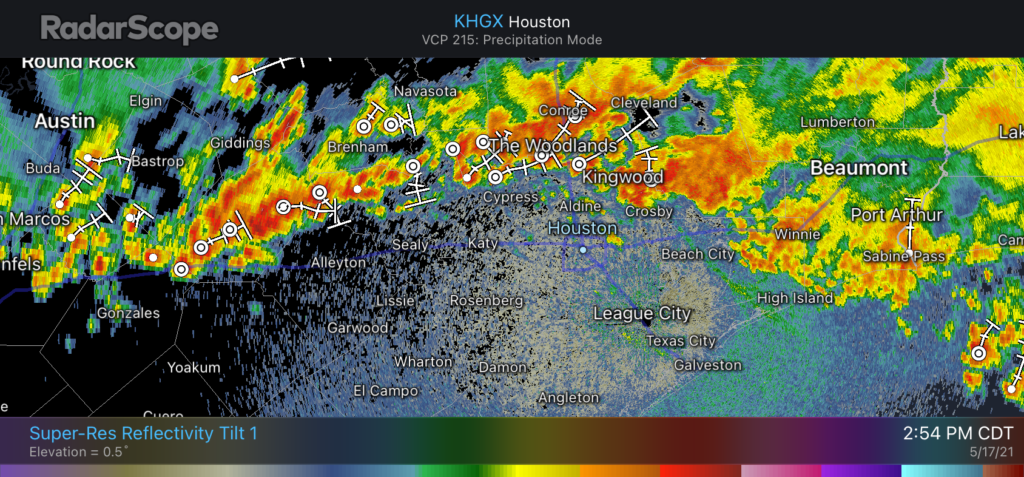
These storms should begin to wind down as the sun sets, and we anticipate a reprieve overnight. Matt will have an update later today on the latest for what we can expect on Tuesday and Wednesday in terms of rainfall and flooding.
How far south should we be worried about tonight?
Man you guys missed this one today. From earlier update:
“For the Houston area, most of us can probably expect accumulations of 0.25 to 1 inch of rain.”
Whatever. Those of us in Kingwood get pounded again. Hooray.
I’m in the loop and haven’t yet seen a drop of rain. You got the short stick, but he has been spot on in terms of averaging out.
So far. Give it time with that line moving south.
Except they never suggest exact amounts in a particular community.
Darren
The key phrase of the sentence you quoted is “most of us.” It doesn’t mean all of us. And “the Houston area” is significantly larger than Kingwood.
Yeah I understand the “key phrase” part of the sentence. What I’m saying is that the storm line that is moving so slowly south will bring much more than the 0.25″-1″ predicted for most it hits so, thus, they will have missed it.
And 2-3 more days of this crap to go. Hooray.
Rainfall has been very light in the Med Center/NRG Stadium area.
Wow did we just have a deluge up in the Champions area, 2.66 inches in an hour. Still raining but letting up.
Haven’t heard such strong thunderstorms in a long time. Surprised us! Heavy rains along with street and yard flooding in Kingwood area. We expect some houses to flood (our son). Hope it abates before expected Wed/Thursday rains. Thanks, guys, for the warnings you give! I know you can not promise, only advise…preparations are up to us.
I have measured 5-3/4” in Kingwood. I am about 1 mile in from 59 between Kingwood Drive and Northpark.
Thanks so much for your frequent updates; very much appreciated.
Just drove in from Newton and it poured the whole way back.
How will Surfside Beach be tomorrow between 10-3 pm? Forecast looks clear, but should I be concerned about red flag conditions/rip tides?
I know this is Space City Weather, but as someone who lives in Wilnnie and REALLY depended on you guys during Harvey and Imelda, it would be really great to hear a little more about this area in your forecasts this week. The roads are flooded here and I’m having flashbacks to Imelda..
SCW warned us last week that we could get between 6-10 inches of rain this week. Definitely got our fair share 45 north of Grand Pkwy. Thanks Matt and Eric for the warning.
The last bad band just went across my home in Sienna. We got 1.24″ of rain in 45 minutes. The peak rate was 2.09″/hr. So that is pushing 2.4″ total rainfall for Sunday and today here.
15+ in Fannett area. Thank God for the reprieve this evening. Praying Wednesday’s forecast is wrong in our favor as much as today’s was under forecast.