Good morning. I am sorry to say that Sunday’s forecast was a “miss” for us, in that we did not anticipate such widespread rain, nor so many thunderstorms. Candidly, I woke up and looked at the radar on Sunday morning, and upon seeing a mass of showers to the southwest of Houston said to myself, “What is that?!?” The showers also kept a lid on temperatures—with a high of just 79 degrees at Bush Intercontinental Airport. Anyway, I believe it is important to be honest with our readers.
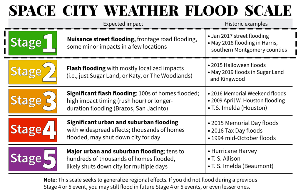
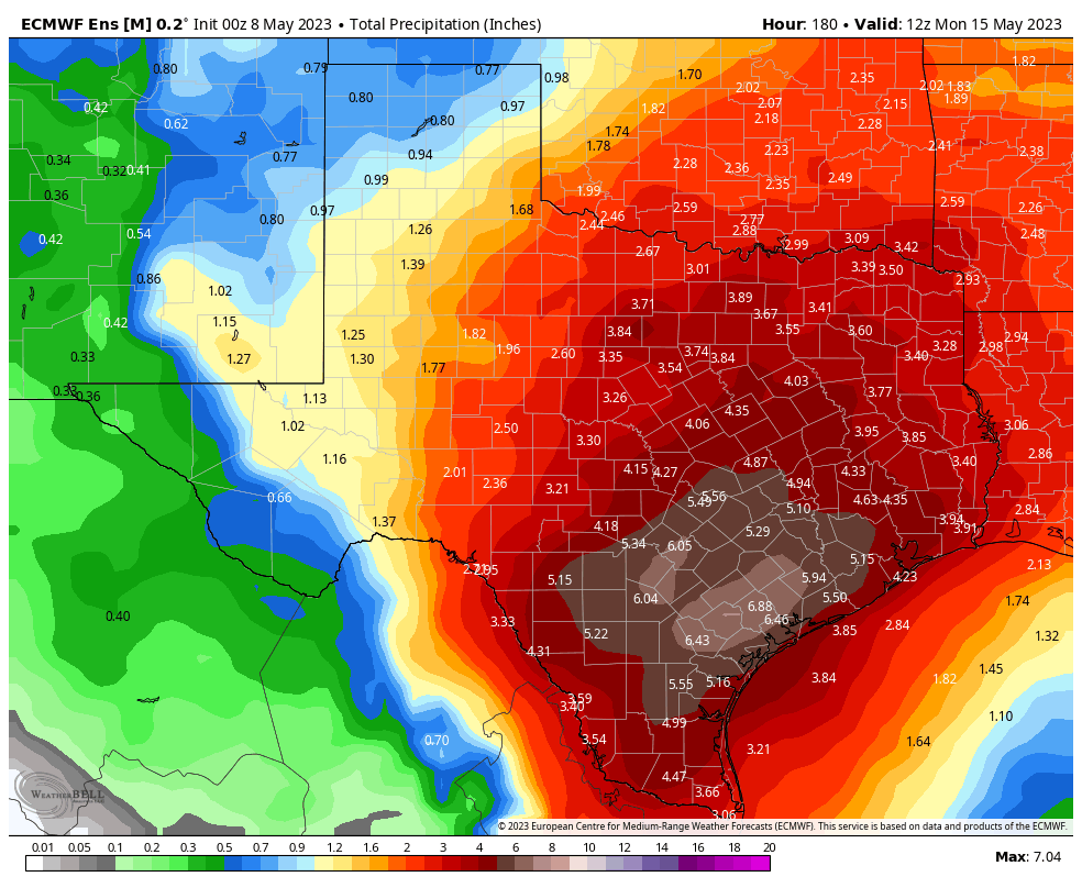
Sunday’s wet weather heralded a much wetter pattern for the week ahead. Most of the area should see 3 to 6 inches of rain between now and next Monday, and we’ll be on the lookout for the possibility of street flooding amid stronger storms. For this reason we are issuing a Stage 1 flood alert, beginning at noon today.

The overall pattern, in absence of high pressure, will be driven by a moist atmosphere with a series of passing atmospheric disturbances. As a result we’ll see on and off showers and thunderstorms for much of this week, and possibly through the weekend. This is the kind of situation during which you’ll need to be paying attention to conditions, as these storms may well pop up during after-school activities or the evening commute.
Monday
Conditions this morning should be fairly calm, with mostly cloudy skies and warm temperatures. However, along with daytime heating, I expect to see fairly widespread showers and thunderstorms pop up this afternoon. It is possible that we see some fairly strong thunderstorms this afternoon, from about noon to 6 pm across the metro-area, so be weather aware. Any storms that develop should weaken during the evening hours. Otherwise, expect mostly cloudy skies with high temperatures in the mid-80s, and southerly winds. Lows will only drop into the low-70s.
Tuesday
A similar day, with muggy air and a chance of fairly widespread showers and thunderstorms during primarily the afternoon hours. Not everyone will see rainfall, but much of the region will, and some of these thunderstorms could be quite strong. Again, this activity should wind down during the evening hours. Highs on Tuesday should again be roughly in the mid-80s, with southerly or southwesterly winds.
Wednesday and Thursday
Both of these days should see partly to mostly cloudy skies, with perhaps a 50 percent chance of rain. However, for now I think the chance of strong thunderstorms is lower. Highs will probably fall somewhere in the mid-80s, with muggy air.

Friday, Saturday, and Sunday
Atmospheric moisture levels will surge this weekend, which could set the stage for even more widespread rainfall. However, whether this transpires will depend on the upper-level atmosphere and whether we see a robust low pressure system drop down toward Texas. So for now the weekend forecast ranges from somewhat wet—scattered, on and off showers—to downright wet with fairly widespread showers and the threat of heavy rainfall. I don’t have enough confidence to make the call yet, but I do know the air is going to be muggy, and we should see highs in the mid- to possibly upper-80s—the warmer temperatures would come in the scenario with less rainfall.
Next week
After the potential for more rainfall on Monday, most modeling suggests rain chances will die down somewhat for next week. It’s possible that some sort of weak front pushes through in about 8 to 10 days, but that’s not something I’m going to bet the farm on.


I’m hoping for no rain on Mother’s Day.
Are there any days in the next week that might have a lower chance of rain in the early evening hours? I need to mow my lawn before I have to bust out the machetes and jungle gear.
It looked like a significant storm. How did you miss that? On the other hand, I feel better that I wasn’t alone in the surprise.
It was a shortwave impulse at the upper levels which are notoriously hard to forecast.
Is it correct that the Euro ensemble mean shown in today’s post does not include the wetter scenario for the coming weekend meaning those totals by May 15 would be way higher in the wetter outcome?
It is up till May 15th and I think it is one of the models that skew toward the wetter outcome.
Trust me, after the steam bath Saturday, I’m not complaining about rain and a high in the 70s on Sunday!
I’ll be as polite as I can…I really appreciate SCW owning up when a forecast doesn’t work out as planned. I get in trouble here for calling out other meteorologists, so I’ll be kind. Folks in “other media” just simply move on, or at times on social media after a particularly bad forecast doesn’t come true, saying “what? You wanted bad weather?” Thanks Eric and Matt for shooting straight with us…
I agree. This site will usually acknowledge a missed forecast as they did today. You never see that with their TV peers or at least I don’t.
Thats because being a meteorologist is a easy target for criticism or being attacked by public for trying to do their job at predicting weather.
If you want to remember about weather prediction, just remember back to Hurricane Rita in 2005 and Dr. Neil Frank from KHOU. He was the biggest doom and gloom spreader, and in my mind is the one that caused the panic of 2 million people (including my families) trying to get out of Houston. Remember all the cars stuck in I-10 W with no gasoline and all the people stuck in Livingston and points north where they ran out of gas. He disappeared pretty quick after that if I remember correctly. And that storm actually ended up going all the way over by Beaumont before turning north. Frank kept saying it was going to veer back to the west and come right up Galveston Bay. We eventually gave up trying to go N and turned around and came back home. We got hardly any wind and maybe a quarter inch of rain. The only one that got it “right” was the guy on Channel 2 (Billingsley?). His comments are what made me turn around and go back home.
Weather guys like Eric Berger and Matt Lanza are a treasure. They own up when they are wrong, and 99% of the time, they are spot on accurate. In my opinion, MUCH better than any of the guys on TV who are chasing ratings..
Thanks for being honest about making or missing your forecasts. Even with all the advanced technology that we have for humanity to predict these things, we still will get it wrong. That’s ok and is not something you guys should be losing sleep over. We, as readers, should be very understanding when it comes to weather forecasting. Your work in this field is much appreciated! Thanks for the humility and earnest desire for perfection.
You never get the weather right. …..
lol.
This was a good week for me to go on vacation, although being in Ireland is about as wet as Houston seems to be. Wednesday night look ok at the moment for flights in to Bush? Thanks for your work! 🇮🇪
This particular area is probably one of the harder, if not one of the hardest, areas to accurately forecast weather in the Spring. SO many factors combine here to make forecasting ‘interesting’ – the convergence of atmospheric levels and winds, flat terrain so there is no disruption for fronts, effects from the Gulf waters, heated air streaming in from the Chihuahuan Desert (if there is enough moisture from the Pacific Ocean, we even get rain out of it!), etc. And let’s not even get into short-term, unforeseeable pop-ups, such as we saw yesterday! In late Fall/Winter, I imagine a Sumo match, with a lot of pushing and shoving, occurring between the warm Gulf Sea Breeze and incoming fronts activated by the cold northern winds. The Sea Breeze does usually take a break, playing Rope-A-Dope with the cold air, but eventually powers back up, and then there is a big Smack Down, with the Gulf Sea Breeze back in its element, putting paid to any notion that it was not the Supreme Ruler of this Realm. This place, a true weatherman’s dream, hahah!