In brief: Strong thunderstorms are approaching Houston from the southwest and will soon spread into the metro area. The period of 2 pm to 6 pm should see the strongest storms, with hail, damaging winds, a few tornadoes, and some street flooding possible. Please take this threat seriously.
As expected, we are seeing the development of strong thunderstorms to the southwest of Houston this afternoon. These storms will gradually progress eastward through the afternoon and early evening hours before they exit to the east. At this point the most severe weather appears likely to occur along and south of Interstate 10.
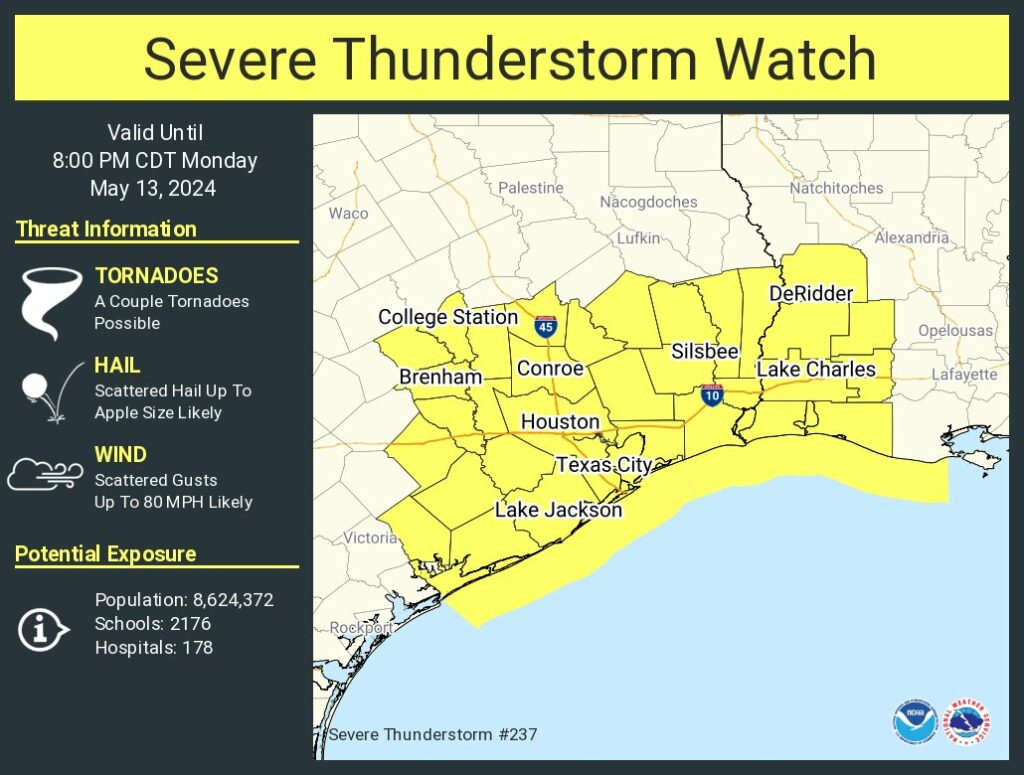
In terms of timing, I anticipate that showers and thunderstorms will begin to develop widely across much of the Houston metro area by around 1:30 to 2 pm. A more organized line of severe thunderstorms will subsequently march across the area from west to east from 3 to 6 pm. The strongest storms should be east of Houston before sunset, with some light showers possibly lingering a little while longer.
There is a fairly high risk of hail with these storms, particularly along and south of Interstate 10. The National Weather Service indicates that a few areas may see hail as large as an apple, but for most locations any hail that falls should be smaller than this. Damaging winds are also possible, as well as a few isolated tornadoes. Heavy rain will also accompany these storms, but the most intense showers should progress fairly quickly. Thus, while some street flooding is possible, we are not overly concerned about a significant flooding event.
We will clear out this evening, and then have a couple of calm days before rain, and possibly storm, chances return Thursday. Stay safe out there, y’all!

Crazy may weather. I hope all are staying as safe as possible during these threats. Stay weather aware please!
thank you for the update !
Thunder and lightning in Westchase at 13.30, but no rain yet.
Rain started at 13:40, ended 14:24, 1/2″ rain.
With apple-sized hail we can make apple hail pie.
Been getting lightning alerts at the plant since 11 AM.
Getting absolutely rocked here in Sugar Land. Day turned to night in an instant with sideways blowing rain and power flickering on and off. Good luck to everyone further north.
I think I brought the hail back with me to Houston! I got caught up in a hailstorm in Port Arthur yesterday and got back into Houston last night!
Y’all are welcome!
The edge of this just finished with us down here near Pearsall, though the worst was more over Uvalde, Hondo and San Antonio. Still, we had lightening, lots of rain (yay!!) and periodic strong winds. Y’all batten down your hatches!
First wave gave us a nice steady rain in Copperfield (~0.7″). No wind. No hail.
Supet
Pea size hail in Webster near Baybrook mall heavy rain and winds at 3pm.
Your timing was perfect.
Galleria was worse than Montrose was, but I see that we have more on the way later. Super fun. Also, people cannot drive in even a tiny sprinkle. I saw some interesting stuff on the way home.
Clear Lake had a brief minute of pea-sized hail mixed with heavy rain. Then it was just the heavy rain for a while longer. Should we expect more?
Power of and on five times in less than 90 minutes…. AGAIN…. just like the last storm to blow through. This is ridiculous. Centerpoint needs to fix their freakin’ grid.
A powerful storm slammed through Sweeny which knocked a tree over on my road. It fell on a power pole so I have no power now. Yikes