In brief: Storms are likely in Houston today, after noon. The line of showers and thunderstorms may hit the area during the critical hours after school, or during the early portions of the evening commute, so please remain weather aware. After that we will have a couple of calmer weather days.
Monday
A number of ingredients for severe weather are stacking up this morning across the Houston area, including atmospheric moisture, instability, shear, and a trigger in the form of a weak front that will push through. All of these factors are likely to produce a line of showers and thunderstorms, some of which will be severe, that will move through Houston from northwest to southeast during the afternoon hours today.
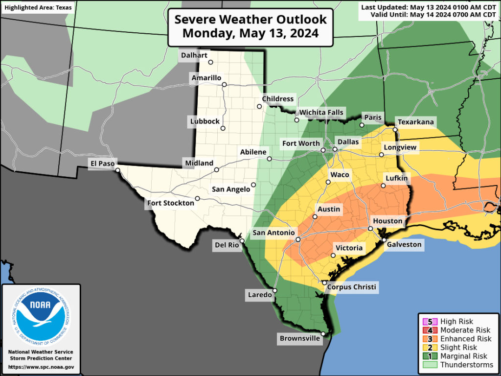
In terms of timing, I expect conditions to warm and muggy this morning, with temperatures in the 80s and mostly cloudy skies. The action is likely to pick up shortly after noon, to the west of Houston. Locations such as Katy and The Woodlands are like to see the onset of storms between 2 and 4 pm, with the line moving into central Houston later this afternoon, perhaps between 3 and 5 pm, and reaching the coast between 4 and 6 pm. I realize the timing here in unfortunate, likely affecting parts of the metro area during school pick-up, afternoon activities, and the evening commute. Please check the radar before venturing out—conditions will be better in some locations than others.
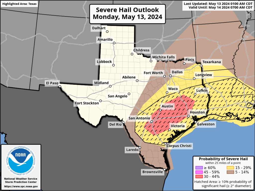
With regard to impact, the line of storms should be fairly progressive as it moves through the area. So the worst of the rain, lightning, and other impacts, including damaging winds, hail, and possibly a few tornadoes, should not last too long. But these conditions may be briefly intense. Some street flooding is also possible during the strongest storms, in which up to 3 inches may fall fairly quickly. After the initial line of storms showers may linger for another hour or two. The bottom line is that today will be a day to be weather aware, especially from noon to around sunset. Not all areas will be affected by severe storms, but it does look like a fairly good chunk of the region will be.
Temperatures tonight should fall into the upper 60s with mostly cloudy skies.
Tuesday
Expect sunnier skies and calmer weather in the wake of the front. Highs will reach about 90 degrees, aided by sunshine and the slight drier air that will allow them to pop up. Winds will be fairly light, from the north. Lows on Tuesday night should drop into the upper 60s again for most of the metro area, away from the coast.
Wednesday
Another sunny day with highs near 90 degrees. Winds will shift to come from the southeast during the day time, most likely, allowing for a slightly warmer and more humid night in the low 70s.
Thursday
More storm chances return on Thursday as the atmosphere becomes more amenable with passing disturbances. Right now let’s call for a likely chance of rain, but with lower confidence in the details. Expect highs in the mid-80s.
Friday
A chance of showers lingers, but the signal is not as strong for Friday. Look for highs in the upper 80s. Details to come.
Saturday and Sunday
The weekend looks mostly sunny. Saturday should bring temperatures in the upper 80s, with Sunday likely reaching the lower 90s. I can’t entirely rule out some passing showers on Saturday, but overall chances are near zero on Sunday.
Next week
It’s difficult to say too much, but at this point I expect summer lite conditions next week, with highs generally in the low 90s. High pressure looks to be mainly in control, but we’ll have to see if that actually comes to pass.

Thanks for the excellent reporting! I love the rain, etc., but the mosquitoes are HORRIBLE.. They are nearly infinite in number and seem hell bent on getting into the house..
setup a mosquito bucket of doom! https://sidewalknature.com/2022/05/08/mosquito-bucket-of-doom/
bucket +water +leaves +Mosquito Dunk.
It attracts mosquitos to lay eggs in the water, then the mosquito dunk kills the larvae, reducing the overall population in your area. Works even better if you remove other breeding locations and get your neighbors to setup buckets as well.
Please don’t rape the environment because you don’t like an important food source for various birds. Just plant local plants that attract birds that will eat, and scare off, the mosquitos and dump out anything unintentionally collecting water. This reduces the problem significantly without harming the natural order, allowing future generations to experience the natural beauty of nature. Besides, there is already a noticible decline in bugs throughout the entire area as it is over the last 20 years, there’s no reason to make it worse.
The bucket trap is one of the best chemical free ways of fighting mosquitos. The mosquito dunks only effect mosquitos, they’re a naturally occurring bacteria that kills their larvae.
If enough people setup bucket traps, it would decrease the use of broad spectrum insecticides that people and the county spray to keep mosquitos under control.
Don’t like the hail threat. At least a daytime issue. Guess we look for green sky as a warning ? …to get the good car under cover.
Is it winter yet?
Only 222 more days
Yesterday’s storm forecast showed a lower risk of severe weather. Why has this changed all of a sudden? I thought weather forecasting was fairly reliable within 2 to 3 days? This is an unwelcome surprise.
It’s becoming more and more a trend. Not sure what data the models are being fed and why the Inconsistency. It’s almost getting to a point to stop listening to forecasts and just nowcast situations.
weather forecasts still serve a purpose even if they are not 100% accurate.
Does very large hail (2 to 4” as per the news outlets) do damage over a vastly larger area than an isolated tornado, or is giant hail also concentrated like a tornado?
As of 10:53am the dew point was 80 at the Angelton Airport. That is not normal for mid May.
So are we doing extreme weather every week now?
Welcome to the consequences of pulling stored carbon out if the ground and adding it to the atmosphere.