In brief: Houston will experience full-on summer conditions this week with hot days, mostly sunny skies, and sultry nights. To better characterize this heat, we will start using wet bulb globe temperatures more, and we explain them in today’s post.
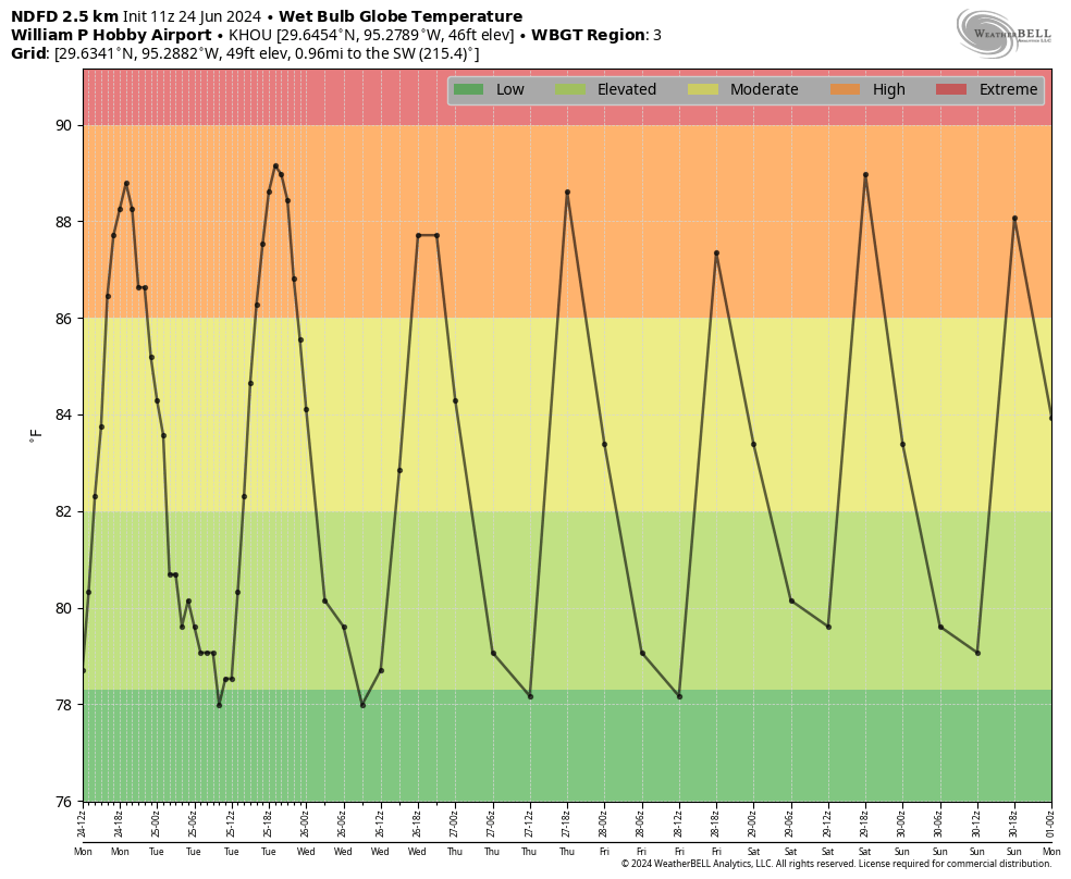
Wet bulb globe temperatures
As we get into the heart of summer—and yes, that’s just what we’re in for during the next 80 days or so—it’s useful to talk “wet bulb globe temperatures.” Now this is a confusing name, and it’s not a simple calculation. To derive a wet bulb globe temperature, one need take three different measurements: air temperature (with a thermometer), mean radiant temperature (with a black globe thermometer), and natural wet-bulb temperature (a water-soaked thermometer). Like I said, it’s complicated.
However, interpreting a wet bulb globe temperature is easy, and we’re going to use it a lot this summer on Space City Weather. Quite simply, it is a measure of how heat affects you: it factors in temperature, humidity, wind speed, sun angle and cloud cover. It differs from the heat index, which is less precise. Using this metric is especially useful if you’re going to be outdoors, and not beneath shade. Basically, “high” temperatures are very warm, and “extreme” levels are borderline intolerable unless you’re in a swimming pool. Note that last year, during this week, we were already at “extreme” heat levels. This year we’re not quite that hot, but it’s still going to be very warm.
Monday
Our weather this week will largely be dominated by high pressure, which will lead to mostly sunny days and highs generally in the mid-90s, with some inland locations reaching the upper-90s. There is plenty of moisture in the atmosphere, but a capping inversion is going to be difficult to break most days. However, I do think areas south of Interstate 10 and closer to the coast have a better chance of seeing some spotty afternoon showers along the seabreeze this week. I’d peg daily chances at 10 to 20 percent, with lesser odds for inland areas. Overnight lows will be sultry, with temperatures only briefly dropping below 80 degrees in Houston, if they do at all.
Tuesday, Wednesday, Thursday
More of the same: Mostly sunny days, highs in the mid- to upper-90s, some isolated seabreeze showers, and warm nights. Winds will generally be from the southeast at 10 mph, with gusts up to 15 mph.
Friday, Saturday, and Sunday
The forecast remains more or less the same for the weekend: mostly sunny and hot. I do think rain chances may bump up slightly into the 20 to 30 percent range, but I want to see how the forecast evolves for high pressure. Will it give a bit, or will it be relentless? We shall see.
Tropics
After the formation of Tropical Storm Alberto last week in the southern Gulf of Mexico, and a couple other disturbances, it looks like the tropics will go into quiescent mode for awhile now. This is perfectly normal for June, which is but an appetizer for the tropical main course, which comes in August and September for Texas.

Seems like a typical Houston summer so far. Statistically .8 degrees above normal at IAH but certainly not oppressively hot for by “our” standards. Hopefully high pressure stays camped off of our east this summer and not on top of us in a dome of death!
I appreciate your website so much! I follow it faithfully and love how great and “user friendly” your explanations are! Thank you!
Raining right now in Lake Jackson…..
I agree.
So far,so good for this summer. Timely rains, seasonal heat,although still unpleasant. I think this summer is vastly better than last 2 summers. Glenn, I’m with you, the ridge that’s visiting us does not appear to be the death ridge variety. Summer doldrums until the Cane season gets back in the game later. As we all have been told, which is forecast to be Gulf- centric.
How did those of uz 80+ ever
Survive growing up w/o ‘wet globe’ tempature?
Get off my lawn!!
We are almost entering the sweet spot of summer. Glad May and June were not extraordinary. Hoping July and August are same.
Thank you for including the Wet Bulb temps in your daily blog posts. As a distance runner who runes into work every day (and home every afternoon) I depend on it to plan my commute. It is also essential information for tradesman and others who work outdoors all day, as well as project managers in deciding how to plan a days work for their crews.
Not trying to be a smart aleck, but if you run to work and home every day anyway, what difference would the wet bulb temp make in your life? Just curious.
I still find heat index more intuitive than global wet bulb. A “feels like 107” is much more straightforward than a gwb of 88 (that even sounds like it’s nice out!). No decoder ring necessary to see if I’m in a “red zone” or parking in a white zone.
I have picked up 5 inches of rain so far this month in my rain gauge. That is already more than I got all of last summer. From June 1st through August 31st 2023 only 3.5 inches fell where I live. This June has definitely been more merciful with rain and temperatures than last June was. Hopefully this trend can continue for the rest of the summer. Our vegetable garden is doing much better this year and I want it to stay that way.
I just want to know if there’s any dust from the SAL in our area because me and a few family members just started having what feels like bad allergies. Head pressure and congestion and post nasal drip. I looked at the SAL maps and it did look like a small area of it streamed in a day or so ago and that there’s a much bigger plume coming later this month. A quick look Friday at the Houston pollen counts showed no pollen, but medium mold spores, so I’m just trying to figure out what is getting us. We just recovered from illness, and this really feels like an allergy.
Where can I find local wet bulb globe temperature information?
When I was watching GMA this morning they were talking about the heat waves every where else in the country, I was thinking abut last year, and how grateful I am that we are not experiencing that yet this summer. Hopefully we can just have a “normal” South Texas summer.
I’m getting to know GWBT. Heat index only reflects 2 meter temperature in the shade plus humidity.
The former acknowledges that it’s a lot hotter in the sun. And easy to remember that GWBT in the nineties leads to heat stroke because you can’t maintain your core at 97F….unless you get to shade and water. Not a real time measurement but good enough for planning outside day work. Plenty of people have keeled over in these conditions when the old bean shuts down without warning.
The peaks are around 18-20 Zulu (2-4P) as expected, whilst simmering under the current “dome”. Without rain, as the ground dries out , I would think we see 90s before long.
I would love to see the WBGT featured prominently ion the SCW app forecasts and point-in-time. There is already a Heat Index tile… why not WBGT too?
Is there any scientific basis on what makes a wet blub temp low, elevated, extreme? Wouldn’t it be better if this correlated to some kind of risk like we do with UV index? Say extreme means healthy individuals should not do exercise in direct sun for more than 15 minutes? Sensitive / unhealthy groups get an advisory?
Regarding the “wet bulb” chart three things:
1) It is a bit difficult to read due to size and clarity of the hash marks.
2) I assume that the time scale is GMT (UTC these days I think) as that makes sense with when the highs occur, 1900UTC = 1400Central.
3) While the left scale is says degrees Fahrenheit I assume that it is in fact the wet bulb index
Isn’t there a tropical wave that supposedly could be entering the W. Gulf on July 1? Won’t that pose a threat to Texas coast?
What is going on? The forecast has consistently been that July and August would be wetter than average here, with the high sticking over the intermountain west and suppressing the southwest monsoon. Instead, for as far out as they go, the global models are showing the high staying around us and the southwest deserts wetter than average! Is the wet pattern here still expected to begin in July?
We just cannot have three death ridge summers in a row, please!!
It’ll be ok. Let’s put on some Shaboozey & just go with it 🎶
just wait until august and september. those are REAL summer months.
I saw that there was a Tropical Wave out there.