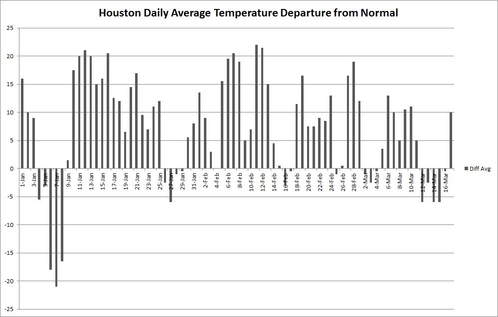
Good morning. Today is the spring equinox, the point at which the Sun crosses the equator. For a nice explanation of why meteorologists generally begin spring on March 1, instead of today, see this post by Braniff Davis. In practical terms, for Houston, this means that days will continue to get longer for three additional months, and we’re going to continue our march toward the dead of summer. It also makes last week’s brief cold outbreak (shown in the graphic below), all the more sweeter.

Today
It’s warmer this morning than it’s been in Houston for awhile, with lows generally having fallen only into the mid-60s. That’s because in addition to a warm flow moving in from the Gulf of Mexico, some overnight clouds helped keep some of the heat close to the surface. But those clouds should mostly go away later today and allow highs to climb to around 85 degrees (and about five degrees lower along the coast). Lows tonight will be in the mid-60s.
Tuesday and Thursday
Similar weather should continue through most of the work week—lots of sun, highs in the mid-80s, lows in the mid-60s. This is warm for mid-March, but won’t be record-setting for the area expect for perhaps the coast, where Galveston’s record highs for this time of year are around 80 degrees.
(Space City Weather is sponsored by an anonymous donor this month.)
Friday
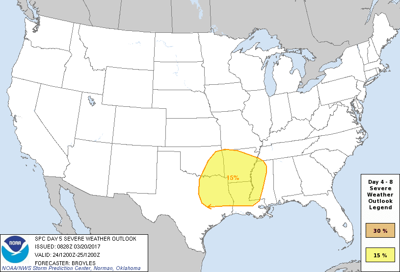
Conditions will begin to change by Friday, when an upper-level storm system begins to move out of the Rocky Mountains and toward the central and southeastern United States. At this point it looks like a fairly large complex of storms will develop near the surface, but most models keep them to the north-northeast of the Houston metro area. Here’s what the NOAA forecast for severe thunderstorms looks like on Friday.

Some rain, at least, is likely later on Friday and into Saturday morning. At this early point I’d peg rain chances at a little higher than 50 percent, with most of the area perhaps getting 1 inch—plus or minus.
Saturday and Sunday
Some drier, and slightly cooler air, will move into the region after the front associated with the upper-level storm system moves through. While it’s too early for super-high confidence, at this point conditions for next weekend look quite nice after any rain ends Saturday, with sunny skies and highs near 80 degrees. Nights should be a bit cooler, in the mid- to upper-50s.
Posted at 6:55am CT on Monday by Eric
We returned from the frigid Northeast to very comfortable warm and humid (I never thought I would be thankful for humidity) weekend. I wanted to thank you for your recommendation of Capital Weather Gang while we were in and around D.C. They were excellent and helped a great deal in our planning and travel.
Glad CWG helped you out!
I think there is the possibility of storms, but I also am betting on a capping inversion keeping them at bay for much of the region.