Good morning. And for those of us who live in the Clear Lake area, it was an early morning as thunder rumbled through at about 5am. I will confess that I did not expect this. So what’s going on, and what does it mean for the forecast?
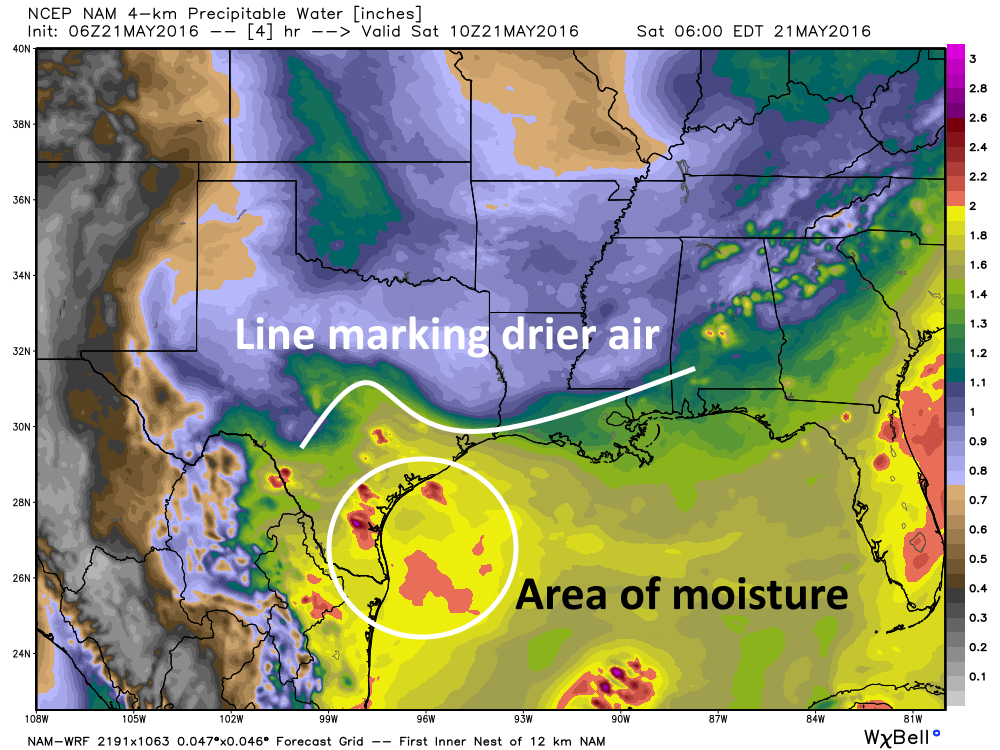
There are a couple of things at play here. First of all, the high pressure ridging that was supposed to keep us drier for most of the weekend and to start next week isn’t quite as pronounced, nor does it extend as far south into Texas as previously thought. We can see the effect of this by looking at a NAM model forecast of precipitable water for Texas at 5am CT Saturday morning.

One thing you’ll see is that, approximately north of Interstate 10, there is a lot of dry air. However across south Texas there’s an area of very moist air (reddish and bright yellow colors). A sounding from Corpus Christi last night backs this model data up by revealing a precipitable water value of 2.05 inches, which is high enough to generate considerable rain. This area of high moisture should expand into the southern half of Houston today.
The second factor is that while there might have been some expectation for a capping inversion to also limit showers and thunderstorms, it appears to be non-existent. Again, last night’s sounding over Corpus Christi reveals no cap at all, and those conditions must extend all the way up the coast to Houston this morning.
So what does this all mean? It means the region, especially parts of Houston south of downtown and west of the city, will face the prospect of some scattered to possible numerous thunderstorms today and Sunday. These storms will be most likely during the afternoon and early evening hours, when maximum daytime heating occurs. But (as this morning’s quick storms over Clear Lake indicated) without a cap they could occur at other times of the day as well. Rain chances increase a bit further on Monday, when the entire metro area has a decent chance of seeing storms. The upside is that highs should remain in the 80s. Also, since I don’t think we’re going to see overly organized storm activity, I don’t see much of a flooding threat.
We could see a bit of a break on Tuesday and Wednesday before the threat of storms returns Thursday and especially Friday, when the threat of heavy rain returns.
Beltway and Westheimer got a good dose of thunder and rain this AM too.
Well crap. I was really looking forward to a sunny day.
Well, that… is very disappointing. Really need an extended break from rain.
Although it’s looked like it might rain at my house (just southeast of S. Post Oak/Willowbend) all day, we haven’t gotten any yet.