In brief: Another round of localized heavy rain, street flooding, and lightning will be possible this afternoon somewhere near or just northwest of Highway 59/I-69 in Houston. Slightly less coverage for Saturday, then more numerous showers and storms come at us Sunday and Monday before we dry out and heat up.
If you live inside the Beltway on the north and west side of Houston, you probably got walloped yesterday. Over 4 inches of rain was recorded at Ella and White Oak Bayou.
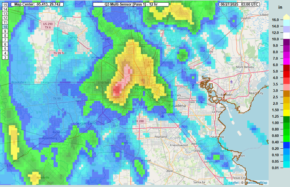
Rain totals north of 3 inches fell in a pretty broad area between The Villages and Garden Oaks. Many other locations saw 1 to 3 inches of rain. Outside the Beltway, it went quiet until you got up to about Kingwood (always, Kingwood) and down into Fort Bend County. Yesterday was just one of those days where boundary collisions ruled the day. A few storms popped up, steering winds were weak, and basically atmospheric bumper cars ensued until we exhausted the instability in the area.
Today
We don’t expect a carbon copy today, however I would not be shocked to see a generally similar setup play out across the area. We’re already seeing some downpours in Liberty and Chambers Counties this morning. As the morning goes on and the sea breeze starts entering the mix, migrating inland with peak instability, we’ll likely see storms fire up near Highway 59/I-69.
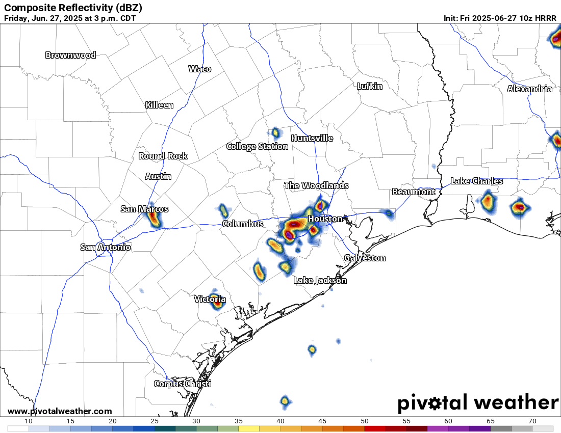
A few places could again see multi-inch per hour rain rates that could cause street flooding. We’re holding off on a Stage 1 flood alert today, but I will admit it’s a close call. Just use caution in any storms today, as you should in summer.
Weekend
I think things will ease up a bit on Saturday. There will be showers and isolated thunderstorms around. There may be locally heavy downpours for a short time in any given spot. But overall the intensity and coverage of storms may be lower tomorrow than it has been to close the week out.
Unfortunately, the same does not hold true for Sunday, which should see more numerous, if not widespread showers and thunderstorms across the region. Storms could begin firing up as early as mid-morning and continue through the day, migrating generally north and west as the day progresses. Have an umbrella handy both days, but have a good indoor backup plan available on Sunday.
Temperatures should top out in the lower to mid-90s on Saturday and low-90s or even upper-80s on Sunday.
Monday
Monday looks like another active day with showers and storms popping with daytime heating. Look for low-90s and scattered PM storms.
Rest of next week
Tuesday begins a trend of diminishing rain chances. Expect more of isolated coverage of storms on Tuesday, a handful on Wednesday, and perhaps none at all by the end of the week. In response, temperatures are going to begin to pick up. We’ll have mid-90s Tuesday and Wednesday, followed by a chance at upper-90s to close the week.
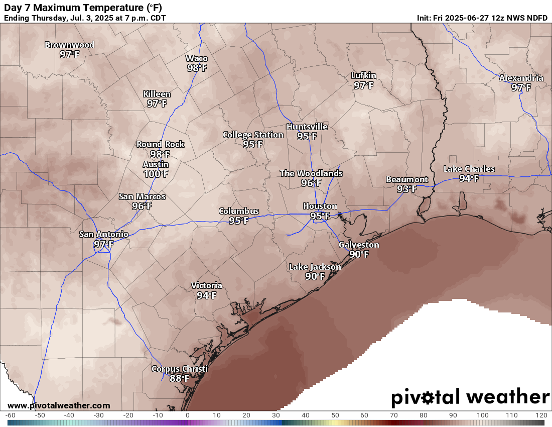
Recent rains and saturated soils may act to keep daytime highs from getting much past 97 or 98 degrees or so officially, but there may be a few parts of the area that threaten upper 90s to near 100 by next weekend. Stay tuned.
Tropics
A discerning eye will notice a new tropical area to watch on the National Hurricane Center site down in the Bay of Campeche. This has a very, very slight opportunity to develop over the next couple days.
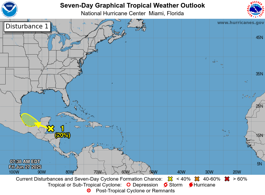
The good news is that it will almost certainly scoot right into Mexico by Monday. This limits any significant development risk, and this is not a concern for the Texas coast. The next tropical area of interest may be something in the northeastern Gulf or off the Florida coast by next weekend. That too is expected to stay away from Texas and is mainly worth watching for Florida or the Southeast coast.

There were multiple times where it got dark and ominous looking here in Katy yesterday, then it went back to sunshine without anything more than a brief sprinkling of rain. Was completely shocked when I saw all the videos on social media, of people waiting out the overflooded streets in other nearby areas.
We had 5.5″ in Acres Homes yesterday. Thank goodness we live on somewhat high ground up here.
Galleria was absolutely slammed yesterday, street flooding and it was just 10 mins more from flooding the basement.
Oak Forest (North Loop/Ella area) resident. In my 50 years here, I’ve never, ever experienced the never-ending ear-splitting thunder and lightning flashes overhead, not even during Ike, Harvey, or Beryl, for an hour and a half. Two and a half inches in 40 minutes at the beginning, before ending at 4 3/4″ total after 90 minutes. Fortunately, the power stayed on, unlike others I’ve read about.
There typically isn’t much lightning in hurricanes. Lightning occurs best when ice crystals and water droplets collide in the upper atmosphere to create electric charges. In order for this to happen you need strong vertical movement of air into the upper atmosphere and it has to be very cold at high altitudes as well. This is most efficient with cold or dry fronts forcing the warm humid air at the surface high up into the atmosphere and during hot summer afternoons when the surface heats up rapidly and the air rises high into the sky quickly.
During hurricanes, there are very strong horizontal winds which halts the vertical movement of air. Hurricanes are also typically warm core lows, which means they suck up alot of warm air at high altitudes, preventing the water droplets from freezing and causing that static electricity charge. There can be alot of lightning in the outer rain bands, but once you get closer to the eye, there will be less and less lightning. But near the center of a hurricane, lightning is the least of your worries.
There is a very high amount of water vapor content in our atmosphere due to being in summer now. The more water in the atmosphere, the higher amounts of lightning there will be because the more moisture you have the more ice pellets there will be to rub together in the upper atmosphere. That rubbing together of the ice pellets causes the separation of charges in the sky that turn into lighting bolts as negative charged ice and dust connect with positive charged objects on the ground. It is one of they ways nature trys to balance out the equilibrium via the laws of physics.
And the warming Earth is causing many storms to have more frequent lightning and heavy rain than before. A warmer atmosphere holds alot more moisture which equals alot more heavy and more lightning.
Thanks, Joseph and Frank, for the explanations regarding intense thunder/lightning vs hurricane conditions!
Well atleast we got to have a somewhat traditional June before being thrown in the broiler for the next 3 months.
Yep sadly. I remember many years ago when I was younger, we would actually get nice fall weather in September. We had many nights in the 60s and 50s with comfortable days in the 70s and 80s. Now September is practically just as hot as August now.
Will you make a post or at least comment on the shut down of SSMIS data that made the news this week and what it means for hurricane forecasting? I quickly checked The Eyewall and didn’t see a mention over there.
I was thinking the same thing. Curious to get their input
If you haven’t seen it yet….https://theeyewall.com/a-couple-minor-things-to-watch-in-the-atlantic-tropics-while-we-digest-the-implications-of-the-loss-of-a-significant-forecasting-tool/
The HRRR map above is a carbon copy of RadarScope at 3:40 PM yesterday. But the forecast says not a carbon copy…why is that…less moisture, less instability, what’s different?
“The good news is that it will almost certainly scoot right into Mexico by Monday.“
Just like Beryl?
Ducking…..
This may be the “coolest” Pride parade in many decades. Still, drink water and wear plenty of sunscreen tomorrow!
Just outside the loop toward Westbury (Harris County rain gage 435), we’ve had the thunder and dark clouds and netted just 0.64 inches over the last seven days. All of the darker radar cells have either scooched right around us and then reformed north or south, or fallen apart on approach. I sometimes wonder if the fairly recent overabundant development of concrete bunker warehouses (heat islands) all along Main/Old 90 causes those redirects.
Interesting you mention that. I used to live in Crestwood, a couple blocks away from Memorial Park, and seem to always get storms that stall over us (opposite of what you describe). Sounds nice until you get standing water in your house twice in 5 yrs
Typical summer “splash and dash” storms, where it can be pouring at one end of the street and bone dry on the other end 🙂
The clouds have been barking for about 15 minutes … so I check NWS Radar site – sure enough, we are on the cusp of a downpour (Magnolia area) … thunder and lightning preceding