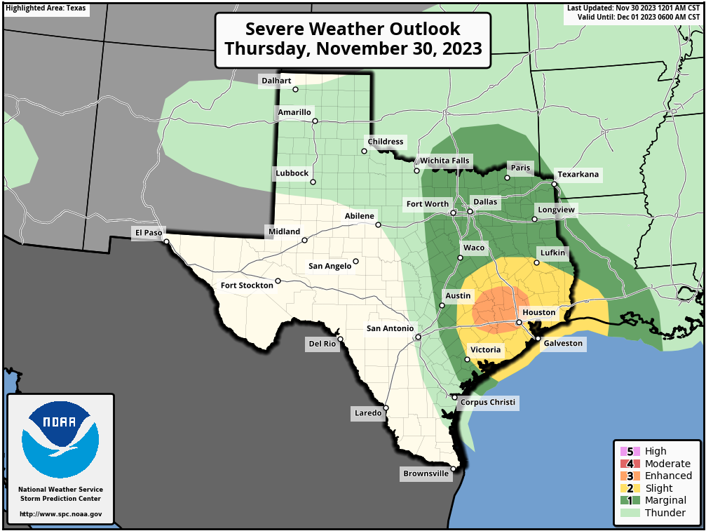
Good morning. As we’ve been discussing this week, there is the likelihood of storms today, with the threat of severe weather during the daytime hours. There are two potential threats that I want to highlight before jumping in to the daily forecast.
Heavy Rainfall
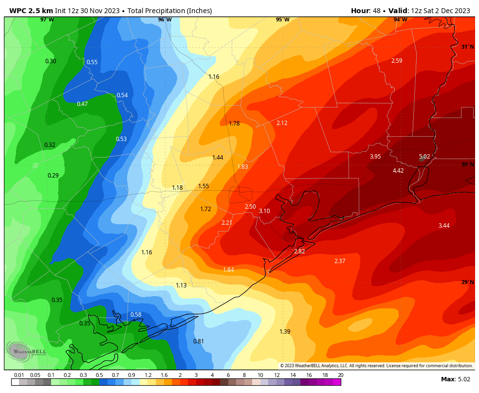
We are already seeing light rainfall this morning across the southern portion of the region, and these showers are likely to intensify during the mid-morning hours. Much of the area is likely to pick up 1 to 3 inches of rainfall, but there is a risk of higher totals beneath the stronger storms. It is likely that areas along, and to the south and east of Highway 59/Interstate 69, will be most at risk for these totals.

To account for potential flooding we are instituting a Stage 1 flood alert, which means there will be a risk of nuisance street flooding later this morning and into the afternoon hours. The worst of the rains should shift eastward during the mid- the late-afternoon hours, and take the threat of flooding with it. Note that the Houston area’s primary radar is down for maintenance. Matt discussed some workarounds in yesterday’s update.
Severe storms
The other threat today will come from an unstable air mass that could produce strong storms. The risk of severe thunderstorms will come a little bit later, beginning during the late morning hours and persisting into late afternoon. It’s a tricky forecast because some of the morning rainfall could sap the atmosphere of energy to produce severe weather. In any case there is decent chance for damaging winds, a few tornadoes, and possibly even some hail to develop in the Houston metro area today shortly before noon, and persisting throughout the afternoon.
Thursday
As outlined above, today will be something of a mess weatherwise. For parts of Houston I think effects will be minimal, but please do be weather aware today due to the potential for severe weather. In terms of temperatures, expect highs of around 70 degrees, with rising humidity. Winds, generally from the south, could gust up to 30 or 35 mph. The potential for rainfall and storms should really drop off by around sunset, and tonight should be fairly quiet with lows in the mid-60s.
Friday
A front will move into Houston from the northwest on Friday morning before stalling near or just offshore. Skies will be mostly cloudy, with highs in the low 70s. Some lingering showers and thunderstorms may redevelop near the coast during the daytime, due to the proximity of the front. Lows on Friday night will drop into the upper 50s for inland areas, while remaining a bit warmer closer to the coast.
Saturday
This will be another partly to mostly cloudy day, with highs of around 70 degrees. Some slight rain chances will linger near the coast. Sometime later on Saturday a reinforcing, drier air mass should move into Houston, ending any rain chances and bringing some cooler air. This will drop lows on Saturday night into the 50s for all but the the immediate coast.
Sunday
This should be a partly sunny day, with drier air, and highs in the mid-60s. Lows on Sunday night will drop into the 40s for inland areas, while staying in the 50s close to the coast.
Next week
Most of next week will bring partly to mostly sunny days, with highs in the 60s and lows in the 40s and 50s. Rain chances look minimal. This will be fairly typical weather for December. We likely will see a bit of a warming trend toward the weekend, with highs perhaps in the low 70s. We’ll see.
Fundraiser
We’re in the final days of our 2023 annual fundraiser. Click here to buy merchandise or donate to support Space City Weather. Thank you!


As of 6am Thur I see a significant rain mass off the coast of LA right now. Another mass is way north of the Hou Metro area, moving into AR / LA … so those are no longer a concern.
Questionable how the rest of the day holds for us up in Magnolia.
Not instantly 80 degrees??? What a miracle for the hottest year so far!!!
It looks like a lot of rain is east. Is it possible this has shifted and we are in the clear? Or is more coming/firing up as the day goes on? Thank you!
So, Deer Park is only at a slight risk for tornados and severe weather…sorry just having a little anxiety from this past January.
I’m in Deer Park too! House was hit in January. While I’m having anxiety, I’m also telling myself tornadoes rarely hit the same place twice. We had ours for the year!
Those who watched Ch 13 last night before bed might not have gotten much sleep last night as you spent the night driving to Dallas to escape the forecasted apocalypse. At least they did give themselves an out in case nothing happened and we actually woke up alive on Friday morning.
Yet another reason to stop watching TV weather news and stick with SCW: home of the “No Hype” forecasts.
Heck, just stop watching any TV news (like I’ve done). If it is a big news event, it will get to you via internet, social media, or carrier pigeon. And, it is all on auto-repeat anyway so you’ll hear about it ad nauseum.
Except that there is alot more disinformation on the internet… best to have options for news
This event isn’t gonna be as bad as it’s being made out to seem