Good morning. The Sun reaches its northernmost extent today in the sky, giving those of us in the northern hemisphere our longest daytime of the year. For today, sunrise came at 6:21 am, and sunset is not until 8:25 pm. More precisely, our day length will be 14 hours, 3 minutes, and 31 seconds. That’s in contrast to our shortest day of the year, on the winter solstice in December, when the day lasts just 10 hours, 14 minutes, and 2 seconds.
We’re going to feel every minute of that sunshine today, with one more particularly scorching day. However, we will see a brief reprieve to end the week, with some healthy (and much needed) rain chances tomorrow. Let’s discuss below.

Wednesday
Skies will be partly to mostly sunny today, with highs again reaching near if not above 100 degrees. However, we’re going to see high pressure start to retreat slightly, and this will open the door to a slight chance of showers and thunderstorms this afternoon. Don’t get too excited. We’re talking about 10 percent. But those odds will improve on Thursday. Lows on Wednesday night should drop into the upper 70s.
Thursday
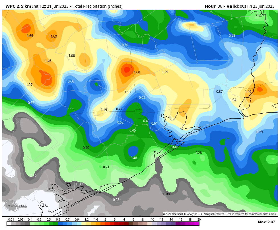
This will be the most interesting day of the week, weather-wise. With high pressure taking a break, we should see showers and thunderstorms developing to the northwest of our region, around the College Station area, before sunrise. Then a broken line of showers should move through during the morning hours. It’s impossible to say whether you’re going to see rainfall. I’d rate chances at about 50 percent, and these showers will likely be hit or miss, with a few areas seeing in excess of 1 inch, and others seeing nothing. On average chances should be better north of Interstate 10. Skies will turn partly sunny, with highs in the mid-90s.
Friday
This will be the second of our “cool” days this week. Look for highs in the mid-90s again, with mostly sunny skies. Another round of morning showers is possible, but overall chances will be much lower, in the vicinity of 20 percent.
Saturday and Sunday
Sunny and hot conditions return for the weekend, with highs of 100 degrees, as the dome of high pressure builds back over Texas in a big way.

Next week
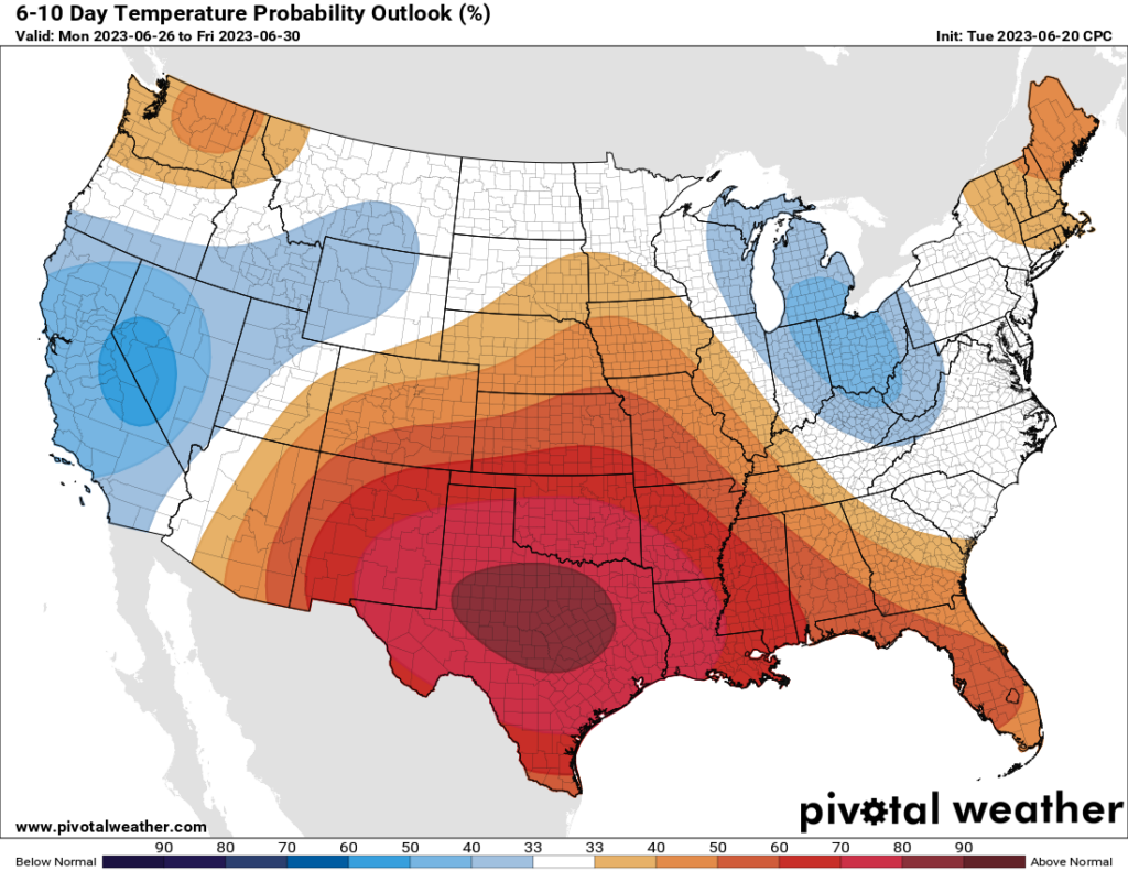
Not much to say, I’m afraid, other than that the heat remains in a pretty big way. There is some hint in the models that this pattern may finally break about 10 days from now, but that’s far enough into the future that my confidence in that is pretty darn low.


It’s been raining all week here. Happy solstice!
Is the high pressure dome going to stay over Texas all summer?
Well I sure hope not!
I’m celebrating the Summer Solstice – because each day’s hours of sunlight is now going to decrease. Fewer hours of sunlight means less heating.
I’ve never been a fan of the rain before but I’m hoping we can get two solid days of clouds and solid dousing. I’d hope the forecast is wrong and we get more next week.
I’m right there with you. The less sun, the better here at 30N in my book. Of course, environmental lag time/latency means that the worst is yet to come, as we are all too familiar with. It’ll take us a couple of weeks just to lose five minutes in a day.
how long can we have this high pressure-what does weather history tell us- I have never hated Houston as much as this year. Does this mean all of July and August can be 100 plus? So depressing. Why does anyone live here?
I ask myself this every summer! Ugh.
This year? Or this last month? We had a great spring and a pretty mild winter.
Hey Candy 🌺 I grew up here, and based on that experience, the end of July and most of August were the 100°+ days. It was the time I loaded water on my bike, which wasn’t even really a thing back then.
That said, the ‘good’ news is that this is a heat dome, and it feels like Dagobah but it won’t last forever. Then theoretically, it should ‘cool down’ to high 90s before some on & off days of 100°+ in late July & early August. That’s based on the past.
Right now, I’m asking as well, how long will this last? Bc its intensity is unnerving. It’s not the hot part of the summer yet (look for Sirius in the sky at that time). I’m hoping this will pass and be gone, and stay gone at least for a while (we’ve had them before, just not this early or at this high-fry level). I’m hoping it’s just an unstable jet stream eddy we’re temporarily trapped in.
This is not typical June weather in Houston. We’ll have to wait it out.
Stay cool. As the Buddhists, ‘This too shall pass’.
🌬❄❄❄
Agree with Cat. We’re stuck between a west coast low and an east coast low because of jet configuration. You can see it on wind animation and height anomaly charts. That pattern will end June 30. I put a date on it because like you, I need hope and I’m not accountable for accuracy like Sci Guy is
Hi Candy 🌺 I grew up in Houston. Based on that, it’s typical to have some 100° days scattered throughout late July and a lot of August. Not tons, but some. That was the time of the year I would strap water to my bike. When Sirius is up high in the sky.
I remember a few heat domes growing up, but not like this. I seem to remember them being in mid/later July & early August. Seemed to be around a week or so.
Also different now is the intensity of the heat: unnerving. I am hoping we’re just caught in a jet stream eddy that’ll straighten itself out. But with so many complicating factors like el Niño onset, unstable jet stream, warm Gulf, I don’t think anyone can really tell how long this’ll be here. Man, I hope not more than 10 days.
After that, I think it’s reasonable to expect to return the regular old hot and oppressive. I just hope no more of this particular stuff.
Eventually, ‘this too will pass’. Just lower your expectations for what passes as ‘decent’ as summer in other places, and it’ll get easier.
Stay hydrated. Wishing you the best.
🌬❄❄❄
Oh wow, my first reply didn’t register for a while. Now are two. sheepish smile 🙃
Just be thankful we live in an age with air conditioning and refrigeration. I noticed a lot of the June records were set in 1909 at a time when few had electricity and fans, and everyone else relied on shade, breeze, or a melting block of ice in the bottom of a well.
The Summer of 1909 was a rough one for sure. A cat 3 hurricane hit our area in July causing alot of damage along the coast. It also came with a really bad heatwave in August. It hit 100+ 6 days in a row with the hottest day being 108 on the 18th in Houston. That was before the advanced urbanization took place. I can only imagine how bad this same heatwave would be if it happened today with Houston’s modern day urban heat island effect.
It is difficult for me to get with “climate change” when some of these heat records and bad weather stories are so old. What was the rationale then? Yes I’ve read we’ve broken more hot records than cold records. The oceans influence weather and some of the so called sloshing oscillations (ENSO being the most famous) last for decades and they don’t line up. Weather patterns are a roll of the dice it seems.
Hey, I enjoy these weather comments here when its so dreadful outside.
Because there is scientific evidence that climate change exists. You can read the data if you want but I can see nothing will change your mind about it, based on your previous comments.
I am willing to accept that average temperatures are warming overall I just don’t agree with blaming every anomaly on climate change especially when much worse stuff happened decades and even hundreds of years ago. When I mentioned the urban heat island effect I was talking about the extra heat absorbed in big cities by concrete and buildings. That definitely makes it easier for records to be tied or broken. I agree heavily that the weather overall is very cyclical in nature and always will be regardless of human activities.
Dude just a TAD freaking off on Wednesday rain sir. Thunder storms rocked the galleria big time!
Why are the temperatures dropping so much (e.g. 87 to 73° at Hobby) every time there is a storm? On some days with storms in the past the temperature barely twitched. Is it because of the northerly winds?