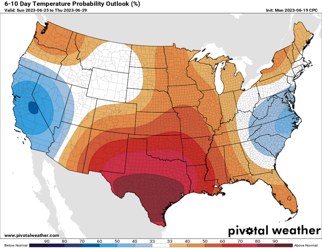
Houston turned up the heat to extreme levels this past weekend, and we’ve got one more day of highs near 100 degrees with humidity pushing the heat index above 110 degrees. After that temperatures will back off slightly for a few days. Unfortunately it now appears likely that this hotter-than-normal pattern will persist through the remainder of June. And after June comes July and August, which is really pleasant to contemplate, you know?
While there is not too much going on with our local weather besides the heat, the Atlantic tropics are unusually active for June. We’ve got all of that covered on The Eyewall. While there are definitely no near-term concerns for the Gulf of Mexico, this is not exactly a great trend for what we might expect later this summer when the Atlantic hurricane season typically get really cranked up.
Tuesday
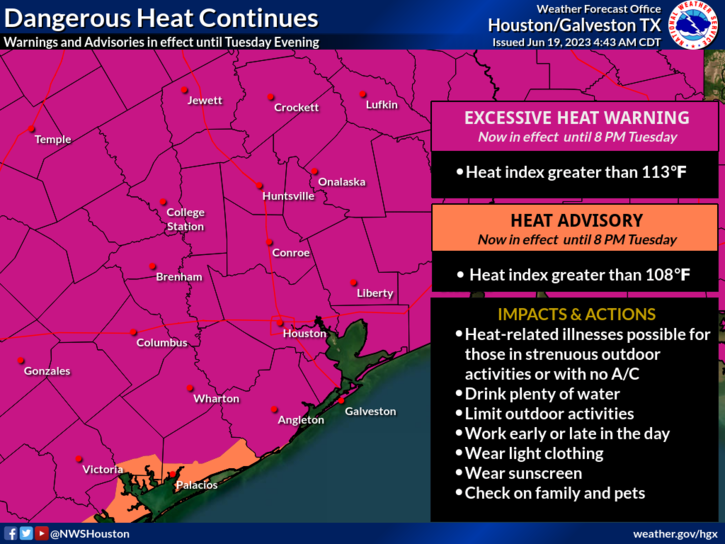
Like the last three days, today will be very hot and mostly sunny. Highs should reach about 100 degrees, with a heat index necessitating an “excessive heat warning” from the National Weather Service. If you must go outside during the middle of the day for a prolonged period of time, please drink plenty of fluids and avoid strenuous outdoor activities. Wear lightweight and loose fitting clothing when possible. South winds, at just 5 to 10 mph, will provide little relief. Lows tonight will not drop below 80 degrees.
Wednesday
Temperatures may be a degree or two cooler on Wednesday, but it’s still going to be brutally hot and mostly sunny. I’d say there’s about a 10 percent chance of rain showers for the eastern half of the area.
Thursday and Friday
These will be the most “moderate” days of the week as the high pressure system backs off slightly. Look for highs in the mid- to upper-90s, with nighttime temperatures perhaps a degree or two cooler. The big thing I’m watching for is rain chances. I don’t want to get anyone’s hopes up, because we’re only talking about a 20 or 30 percent chance of rain as instability works its way into the atmosphere. But this is the best chance of rain for the rest of the month, probably.
Saturday and Sunday
As high pressure builds again, temperatures should climb back to about 100 degrees each day. Sunny and hot, rinse and repeat.
Next week
Hey Eric, does it look like we’re finally going to get a break from this heat wave next week?
No.
Don’t do that to me man.
Ok, at least not during the first half of the week as high pressure remains entrenched over South Texas and Mexico. Maybe by Thursday or Friday of next week? Possibly. Sorry folks, it’s pretty grim.


This is why I never complain about cold, winter my weather. I’d take that over this BS in a heartbeat. How many days until Fall Day??
I agree 100% with this – you can always put on more clothes in colder weather but there’s a limit of how much you can take off in public before they arrest you.
Plus, this combo of heat and humidity is the worst of the options. I’d be okay with “hot + dry” or “cool + humid” but not this. Bring on Fall Day stat.
I second and third this preference to temperature.
Is it correct that the high pressure over us offers some protection from a tropical storm coming this way?
If so, would it be fair to predict that hurricane chances for arriving here are minimal for the next week, two weeks?
Thank you.
It sounds like you should check out The Eyewall, Eric & Matt’s other site, and see exactly what the current state is of the season overall!
Still better than 2011, when we had never ending triple digits and drought.
I use the weather app that comes with iPhone. It always shows percentage chance of showers last few days. Why? No chance.
Something is off with them. We were comparing weather apps at work last week and Apple’s weather app was showing 70-80% chance of rain over the weekend while every other app was showing 10% at the most – almost all of them were 0%.
Apple sucks
This close to the coast rain, no matter how little the chance, is always a possibility.
Any idea as to what needs to happen meteorologically (beyond the end of summer) to move the high pressure system permanently? I want to know what I should be praying for.
For me, I am looking for convection to be able to get in from Baja SW. Get one of the apps where you can look at animated wind. My recollection from the middle of the 2010s was you could see weather come in from that direction in the summer (barring tropicals from the GOM). The current animation shows wind blowing hard north-south along the southern west coast which maybe explains the cold SSTs there. I think that needs to change. I am not a meteorologist. I just have been studying the weather patterns here since the 2011 drought and have like 2 pages of apps. Ha ha. Being adjacent the high Mexican Plateau reminds me of the climate in countries on the other Gulf. And the climate here is remarkably different from say NOLA.
The upper level high pressure ridge that dominates our weather during the summer usually starts to break down and shift further South in September or October allowing for rain and cooler temperatures to return to our area. This is due to the tilt of Earth relative to the sun. For further details research Global Circulation. The short answer is that we will probably not see much relief until the Fall unless we can get a low pressure system stall out over us later this Summer. It may be a long time but relief will always arrive eventually.
While there have been a lot of 100 degree plus predictions we have only hit it once and it has been very breezy which helps. This high pressure is centered over Mexico and not Texas and Oklahoma as is typical for our normal heat waves. It’s hot but it could be a lot worse.
I know you’re right but every year when we get this heat it feels like it’s brand new, and I’ve lived here for 46 years, haha! I hate the heat! My AC can not keep up, thankfully we just bought a new house!
A question for Eric and Matt……
I monitor two different PWS sites tied in with the Weather Underground network. One is just to my east (maybe 200 yards away) and one is just to my west (maybe 1/2 mile away) The temperatures they report, actual air temperature and dew point, are a bit higher than what the TV guys say for Sugar Land or Pearland (all within 10 miles or so of me). And when you use them in a heat index value calculator, it computes to REALLY high values, like up to 120 F. These are a lot higher than what the TV guys report.
Am I missing something?
I would ask how these sensors are sited/situated and are they properly calibrated? There are specific housing and siting requirements for official recording sites.
Yes, I fully understand your comment. I have driven by both of these two houses, and in my opinion they are situated okay. As far as calibrations, I have not a clue. But there are actually two other PWS sites within 1 to 1.5 miles of me that also read the same range of temperatures and dewpoints.
Again, it just seems like the sites the TV guys use for their data (airports for most part) report lower than what we are really seeing around the area.
BUT, it is just nasty hot out here right now, that is a given.
The radiation shields (sun shields) may not be properly installed and may be getting bad readings from reflections of pavements, roofs, pools, or other factors to report an artificially inflated air temp.
Welp, time to start watering along the foundation it seems.