Good morning. I wanted nothing more than to start this week by writing a hopeful post about Houston’s forthcoming weather—to say something about cooler weather ahead, more moderate nights, or a few days of steady rainfall and cloudy days. Alas, this is a reality-based site, and I’m sorry to say the rest of July looks very sunny, very hot, and mostly rain free.
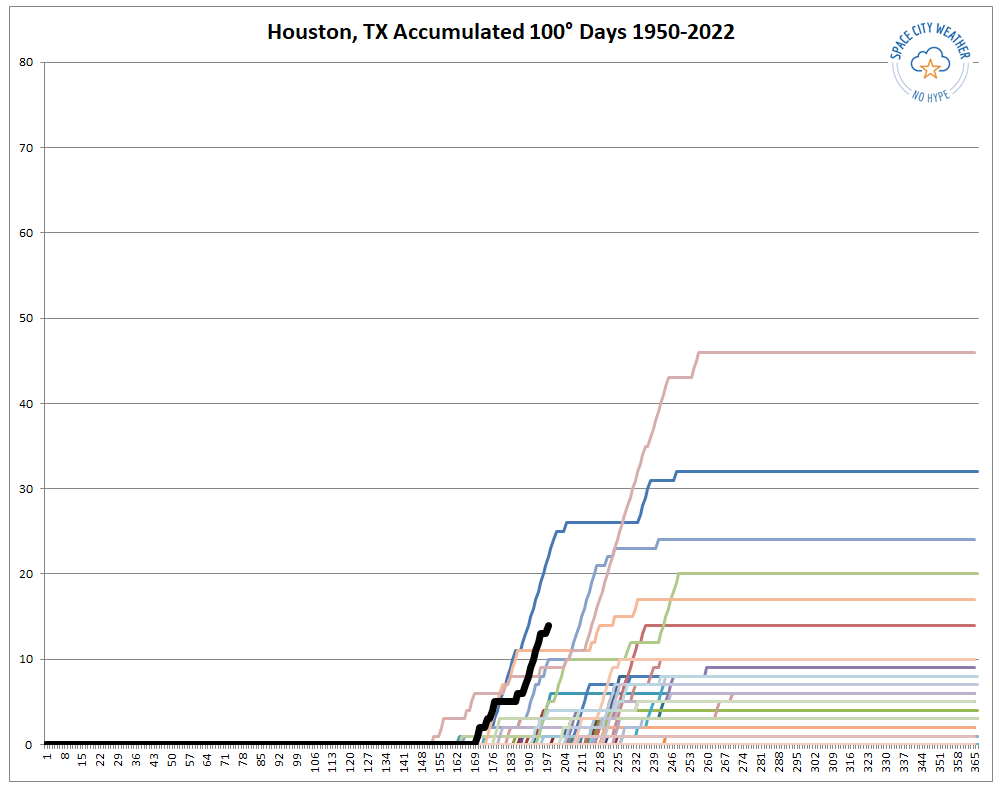
Before jumping into the forecast, dreadful though it may be, I wanted to provide a situational update on our 100 degree days this year. These are officially recorded at Bush Intercontinental Airport, which is the city’s official monitoring station. Through Sunday, the city has now recorded 14 such days, which places this year second only to 1980 in terms of accumulation through July 17. Matt has been tracking these dates, and prepared the line chart below to show how this year (black line) compares to to most summers. Of note are years 1980 (Blue) and 2011 (pink).
Monday
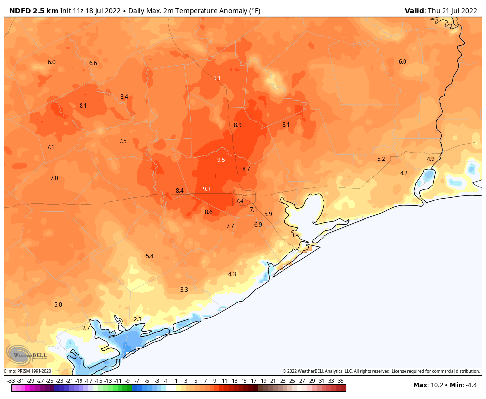
High pressure is back, and it will be the dominant factor in our weather for the week ahead. This means mostly sunny skies for today, with highs near or above 100 degrees for inland areas, with highs in the low- to mid-90s near the coast. Winds will be light, out of the south or southwest at 5 to 10 mph. Lows will be sultry, only dropping to about 80 degrees in Houston. Rain chances are 10 percent or less, due to a capping inversion that is helping to prevent air at the surface from rising.
Tuesday
Rinse and repeat, although there will be precious little rinsing due to a lack of rain.
Wednesday and Thursday
Both of these days will be sunny, and perhaps a degree or two warmer as the high really takes hold.
Friday
Some sort of weak disturbance may attempt to pass over the area toward the end of the week, and this could bump up our rain chances to about 20 or possibly even 30 percent. It ain’t much, but it’s probably the best we’ll see this week.
Saturday and Sunday
These should be mostly sunny days, with highs of around 100 degrees. Rain chances at this point don’t look to be zero, but they are less than 20 percent.
Next week
If you’re looking to the extended forecast with some hope of a pattern change, I would say two things. First of all, congratulations on being an optimist. The worlds needs more of you. The second thing I would say is to remind you that August begins in 13 days.
In the plot above, what year is the tan line with the most (later) days over 100?
Gotta be 2011, I would think.
Yea, the article says it’s pink but it looks kind of tan on my screen. So that’s 2011 for sure.
Wish also included Hobby with long term comparisons. What year did Houston’s official statistics switch an hour drive north? Substantial difference in weather that much further from Gulf.
If memory serves correct, Bush Intercontinental Airport became Houston’s official weather location in 1970.
No, I didn’t live here then and I remember when they changed. Sometime in the mid to late 80’s
Pretty close, according to weather.gov. Says IAH became the official location when it opened in ‘69. I was still a couple years from arrival at the time, so can’t confirm. :). But it seems official enough.
Forgot the link: https://www.weather.gov/hgx/climate_iah
Only (roughly) 66 days until it is traditionally autumn here in the Northern Hemisphere.
Even my optimistic self is frazzled by all of this relentless heat. The Borg Heat (cousins of the regular Borg) says: “Resistance is futile.”
I treasure your humor. And, yes, I am an optimist.
Blow Torch Season is upon us!!
Any thoughts on if the weather pattern will change to end the drought? I may have to buy more equipment to let my son’s boy scout troop safely have fires/heat in a way that complies with a burn ban.
July/August would not be times when you should expect a major shift in the N. American pattern. The jet stream is to our north and of a persistent amplitude. It’s generally a less active time of year. At this point, aside from weaknesses in the high that may occasionally occur and allow some sea breeze precip activity, some sort of tropical messiness will likely be the only saving grace.
I dont think I was very clear with my question. Is there any indication that the pattern of drought will continue through the fall and into the winter? We dont start camping until late September. I’ve lived in this area my whole life and I know all too well what August/September have in store for us. Thought I’d ask the experts here before I spend $300 of the troops money on portable pot belly stoves and welding blankets to put underneath them.
Gotcha, sorry. Odds for La Nina forecast decrease going into late summer, but it’s effects will still be felt here. It is forecast to pick up again fall into winter 22-23. Seasonal forecasting for summer into fall is risky, but absent a major pattern shift, which is high risk to forecast right now, it seems hard to expect there being significant change to the precip forecast. The answer you may be seeking, given it’s mid-July, is likely on slide #31 of this presentation: https://www.cpc.ncep.noaa.gov/products/analysis_monitoring/lanina/enso_evolution-status-fcsts-web.pdf
You should start tracking the Pacific Tropic SSTs on NOAA website. Great fun and then some of the mystery goes away for you. They update monthly. As TimL says there has been a persistent La Niña (falling SSTs w/ little summer temperature recovery) – good correlation with drought…summer and winter. While last year had just normal rainfall it did not make up for 2020 drought and now we’re in further water deficit over 3 years. This is an un-virtuous cycle of dry ground making more intense heat. I would expect fall to be dry if July SSTs don’t show warming. Enjoy!
“The second thing I would say is to remind you that August begins in 13 days.” This might be interpreted the wrong way by those of us who have recently moved here.
August is the dog days of summer with typically the worst heat and humidity, and an increased chance of tropical activity likely to threaten Houston.
August is usually our hottest month where we usually see some 100° days. As you may have noticed, this year we’ve had record heat and it will continue into the next month.
I too enjoy your humor, or very honest chagrin, regardless of the forecast. It’s a very personable read. Thank you!
Is it wrong to hope for a weak hurricane to get us some much needed rainfall?
I would prefer a disorganized tropical disturbance instead of a hurricane
What is the latest 100* day we’re ever recorded? Maybe that is when we can finally hope to cool down.. Looks like around the end of September from the graph.
It was on September 27th 2005. I remember that summer as a kid. That was a really hot relentless one. Luckily it is pretty rare that we see triple digits that far into September. Usually it’s on or about the 3rd week of September that we get our first fall ish front that drops lows down into the low 60s and sometimes upper 50s. Late October going into November is when we finally truly cool off to where most days are in the 70s for highs
It seems the jet stream, which could possibly get rid of the high pressure heat dome, now seems to summer in Canada and winter in Texas. This seems to add to summer heat and winter freeze.
You can thank a persisting La Nina for this. Going on three years now.
IF I recall, last summer there were zero days that reached 100 degrees
Yes that is correct. Last summer was also very rainy and cloudy which helped keep temperatures down. Multiple low pressure systems stalled out over Texas last year which kept it rainy and cooler. This summer has been a high pressure dominated summer.
On the positive side, the high pressure seems to be keeping the humidity down. Been seeing some really nice summer evenings the last few weeks. Some with nice breezes.
I absolutely agree. While these daytime temps have been high, the evenings have been wonderful with the low humidity. I don’t think that’s being appreciated enough.
Man dude, you sound depressed. This is Texas after all. And if I am not mistaken the last two summers were pretty mild. I’ve lived all over the state and guess what? It gets hot in the summer. Sometimes hotter than others. Pfft.
Thanks goodness that the MID-POINT in summer is August. (Sarcasm spoiler.)
Interesting correlation that 1980, 2011, and now 2022 are all years of rapidly intensifying solar cycles as well!