We again want to express our best wishes and thoughts for so many of our readers, Houstonians, and Texans who are outright suffering tonight because of the combination of a true “tail event” and who knows what else happened with the power grid (which I sincerely hope is transparently communicated to Texans in the days and weeks ahead). Please, if you’re one of the fortunate ones tonight, check on anyone you know that may not be so fortunate.
That said, we are a weather blog first and foremost and we want to let you know about a couple things: How tonight’s forecast is tracking and an update on Wednesday’s storm.
How cold tonight?
We’ve been asking this question for days when it was apparent that tonight would be the main event for cold. So, we have a lot of models and data and whatnot, but let’s actually compare to data from the most recent comparable event: December 1989. On December 23 and December 24, 1989, Houston (Bush Airport) hit 7° and 11° respectively, close analogs to what we believe tonight’s low temperature will be. One way to check on how things are going is to track the temperature at Bush Airport hour by hour and compare to the hourly observations in those events, as well as the NWS point forecast from just before 8 PM this evening.
Hourly Temperatures at IAH Airport December 1989 vs. February 2021 |
||||||||
| 12/23/1989 | 12/24/1989 | 2/15/2021 | NWS Point Forecast | |||||
| 6:00 PM | 19 | 24 | 21 | 21 | ||||
| 7:00 PM | 18 | 19 | 20 | 20 | ||||
| 8:00 PM | 16 | 16 | 19 | 17 | ||||
| 9:00 PM | 16 | 15 | 18 | 15 | ||||
| 10:00 PM | 15 | 14 | 14 | |||||
| 11:00 PM | 14 | 14 | 13 | |||||
| 12:00 AM | 13 | 12 | 12 | |||||
| 1:00 AM | 12 | 11 | 11 | |||||
| 2:00 AM | 11 | 12 | 11 | |||||
| 3:00 AM | 10 | 11 | 10 | |||||
| 4:00 AM | 10 | 11 | 9 | |||||
| 5:00 AM | 9 | 11 | 8 | |||||
| 6:00 AM | 7 | 11 | 8 | |||||
| 7:00 AM | 7 | 12 | 9 | |||||
| 8:00 AM | 8 | 15 | 12 | |||||
| 9:00 AM | 10 | 22 | 15 | |||||
| 10:00 AM | 14 | 27 | 18 | |||||
Through 9 PM at least, we are coming up short of both nights from 1989 as well as the current forecast. All that said, it’s very early still, relatively speaking, and temperatures on nights like this can easily drop like a rock under the right conditions. So don’t read too much into what you see here just yet, but I felt this would be an interesting way of looking at things.
If you are unable to sleep or have too much time on your hands tonight (like me, probably) and you want to track our progress through the night, you can check out real-time IAH observations at this link.
(Editor’s note: Replace “IAH” in that link’s URL with whatever airport code you desire, if you’d like to track conditions at that location. Some local ideas? GLS for Galveston, HOU for Hobby, EFD for Ellington Field, LVJ for Pearland, SGR for Sugar Land, TME for the west side of Katy, DWH for Tomball, and CXO for Conroe. You must keep the “K” before those three letters though!)
Wednesday’s Storm
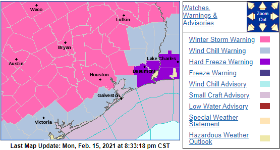
The National Weather Service has issued a Winter Storm Warning for Wednesday’s storm now.
Here’s what I can tell you confidently tonight:
- The precipitation will fall as either plain rain or freezing rain. Sleet or snow are unlikely in our area.
- Precipitation should break out around Midnight, give or take a few hours Tuesday night/Wednesday morning.
Exactly who sees freezing rain vs. plain rain? That’s the forecast challenge right now, as shallow, dense cold air is not always easy to dislodge. If we look at the HRRR model forecast for tomorrow evening at midnight, you can see roughly where it predicts the freezing line to be located.
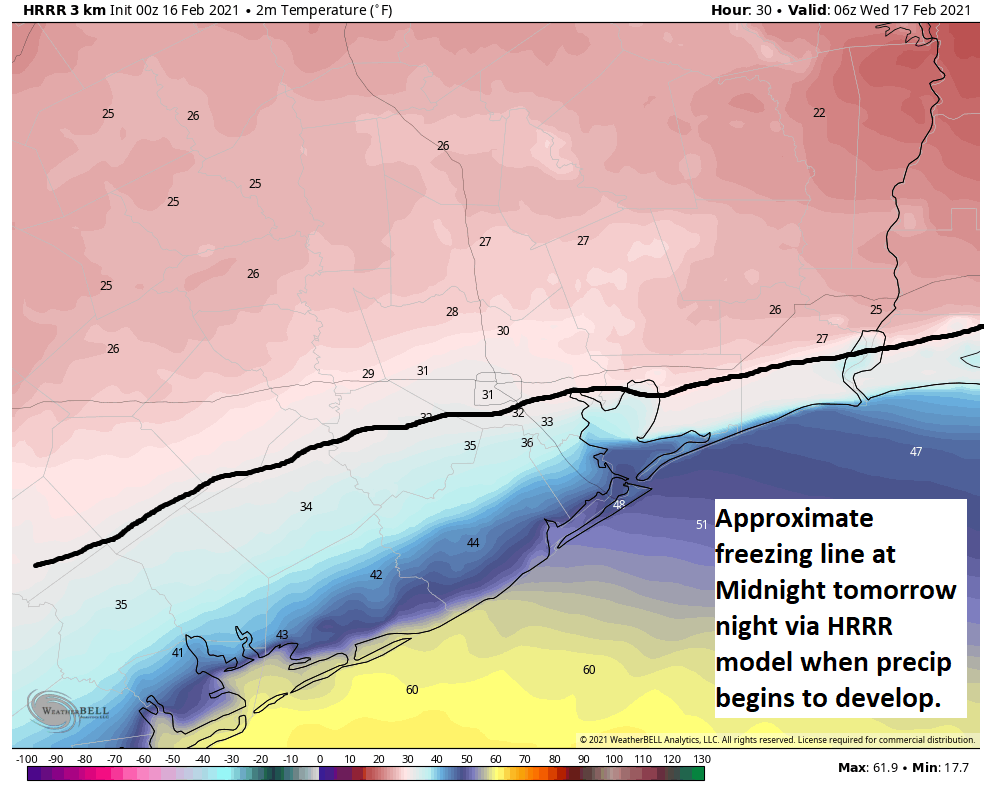
This is essentially just north of US-59 to Houston and east along or just south of I-10 to Port Arthur. The European model and NAM model are slightly warmer than this, and the GFS model is very similar to the HRRR. All models show temperatures getting above freezing by mid-morning or so Wednesday across the entire region. Expect at least a few hours of freezing rain in Houston, with a longer duration as you go north. Total icing may be as much as a glaze to a tenth of an inch across Harris County, with higher amounts possible as you go north into northern Liberty and Montgomery Counties and even more from Walker County northward. For most of us this shouldn’t be a “power outage” issue, but rather a travel one. Expect travel to become difficult to impossible north of I-10 or US-59 after midnight Tuesday night, but we will likely see improvement from south to north after sunrise.
Things could change, but that’s what it looks like right now. We want you to be aware and be smart about this next storm, so that’s why we have this here. Eric will have more for you in the morning. But right now, just focus on getting through tonight. Our thoughts are with you. Please stay safe.
ERCOT has a LOT of explaining to do when this is all over.
As always, thank you for being straight forward with your forecast! No hype! It’s appreciated. Stay warm and be safe
Always trust your reports, you tell it like you see it, and that, without hype in such horrific situations, is calming. Appreciate all you do, always👍👍👍🤗
You guys are so terrific,even under these circumstances. Thank you for your expertise and caring
Thanks for the coverage throughout the day.
Seems like some people must look for some one or some entity to blame for every happening as though they intended to cause people to suffer.
Sorry but 1.4MM people without power for more than 24 hrs on an anticipated, historic cold front does indeed require some explanations. And somebody (could be company) SERIOUSLY screwed up. People’s lives, man!
Thank you for letting us know when to expect updates and for your hard work providing them. I’ve been looking forward to reading your posts through this long day. My house has had no power since 2am last night. Yours was the only site I could find that clearly explained what happened to the power grid and what to expect. I appreciate it immensely.
Wishing everyone a safe night and sending lots of good vibes.
This would be an excellent time for Texas to reckon with the shortcomings of natural gas and wind power. We are a developed nation. This shouldn’t happen.
How does Europe do it?
Nuclear power: Always on.
Tweet from Eric about an hour ago at https://twitter.com/spacecitywx/status/1361500634780995587?s=21
Whoah. Just heard the South Texas Nuclear Plant is down. Another huge loss to state’s generating capacity. Explains why the number of outages are increasing this evening.
Eric and Matt, Thank you for running the best weather website in the city and your hard work during this storm!
Seems like there are lots of folks looking for someone to blame for any and every inconvenience in life. I’ve been in Houston since 1958. To say the least, this is a very unique event. The power outages are certainly regrettable, but sometimes Mother Nature can overwhelm even the best laid plans.
TJ, Very well said. Thanks! And thanks to the guys for Space City Weather, the best.
I’ve shared SCW posts/emails with my friends in Houston and as far away as Copenhagen. All are amazed at the clear language forecasts and explanations. Thanks!
My power came back on tonight just as we were ready to endure a real cold one inside. (It could roll off again… ) I want to thank both of you. Besides being a weather nerd, Eric is a true journalist and he has done the best reporting on this ERCOT issue that I’ve seen.
Thanks for a detailed report. https://www.reddit.com/r/houston/comments/lkucm6/16_hours_and_no_power_start_calling_your/ shows info on calling your rep on fixing this power outage & doing more disaster prep in the future.
Power in my ‘hood (Timber Creek/Spring Branch) back on at 1:45 am. Temp in the house was down to 46 degrees. Hoping power continues – at least thru today, if not thru the next “Event.”
Power back on in Westbury at 3am. Brrrr.
SusanW
Thanks SCW for the ongoing and succinct weather info. We’ve been out of power since 5:am here in Katy/Cinco. We’re hoping for power restored sometime Tuesday. I’m born/bred Texan/Houstonian, so bring on the heat!
League City/Brittany bay area. Lost power @5:45pmand that was it. Out all night. It’s cold, y’all.