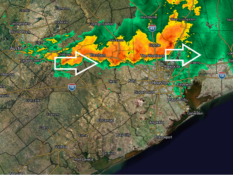
Very heavy rains that developed over the Brazos Valley earlier today have moved ever so slowly eastward, into Montgomery, Washington, Waller and San Jacinto counties this evening. As of 6:30pm CT some areas in these counties have received in excess of 6 inches of rain in the last couple of hours. For example, a location along Lake Creek between The Woodlands and Conroe picked up 6 inches between 4:30pm and 6:30pm. With heavy rains like these watersheds will fill up quickly. This is a serious flooding situation.
INTENSE RAINS
Unfortunately there’s a long line of storms stretching from north of Houston all the way to Austin. Based upon radar trends and short-term model forecasts it appears this line of storms will progress slowly to the east, likely through Montgomery County and northern Harris County for at least the next few hours.

These storms are producing very strong updrafts, and are building in additional storms behind them as they move to the east. They are also pulling in very moist air from the Gulf of Mexico which should help ensure the atmosphere remains charged with moisture for at least the next few hours.
Additionally, the boundary along which these storms are forming is continuing to sag slowly to the south, which could allow some of these heavier rains to move into the central Harris County area later this evening. I’m concerned about the possibility of heavy rain along and north of Interstate 10 during the overnight hours.
If that weren’t enough, some of the short-term models suggest another broad area of storms will move into the entire Houston metro area from the west-southwest early on Friday morning, pushing through the area sometime within a few hours of sunrise. I don’t have enough confidence to predict rainfall amounts. What we do know is that some of the stronger cells within the storms we are now seeing are capable of producing rainfall rates of 3 inches an hour, or higher. The bottom line is that flash flooding is likely over the northern half of the metro Houston area this evening, and by early Friday we may have some concerns about areas closer to the coast, too.
We’ll stay on top of it.
SEVERE WEATHER
Aside from flash flooding, these storms have also produced some severe weather. There was at least one confirmed tornado in Bryan/College Station today which damaged some homes. And wind gusts of up to 90mph were recorded along Highway 105 between College Station and Conroe today.
Posted at 7pm CT on Thursday by Eric Berger
We are in Kingwood and are bracing ourselves accordingly. Your excellent coverage is much appreciated!!
Thanks Kendra — good luck tonight.
Thanks for telling the science behind our weather! It’s always so interesting. The storms that may move along the northern part of I-10, you said “this evening.” Are you speaking more in rhe next couple of hours or more like over night?
Yes, “this evening” for me generally means 7-11 pm, and overnight is after that.
Traveling to Kinder Louisiana tomorrow, what are your thoughts on I 10 travel around 11 am?
I think Houston will probably be clearing out by mid-morning, so if you don’t leave until 11 am I think conditions will probably be OK.
Great! Thanks!
Thanks !!!!
Let’s hope we don’t have to come up with a new name this year for memorial weekend floods.
Maybe we change the name of our city to “Flood-ton” or simply go with “Atlantis”. Sheesh. This is getting beyond ridiculous.
8″ here in the back of The Woodlands so far.
My parents got over 6.5 inches of rain in two hours this afternoon in Panorama Village, Conroe. Power has been out since before 5:00 and trees down all over. Scary stuff.
Any last updates this evening?
One more just now, then bed!
I emptied my rain gauge about 9:30, it had almost 8 in. Typically it has somewhat less than the official rain fall amount as there are lots of trees around. (We are in The Woodlands.) The thunder and lightening have finally stopped for now.
Thanks for keeping us updated today.
Stay dry as best you can! Crazy rains up your way today (and tonight).