Houston will see some spotty rain chances today before a cold front blows into the area tonight and brings chilly, holiday-like weather to the region for Thanksgiving. This will provide a nice contrast to the holiday’s weather the last two years, which has been muggier, with high temperatures in the 70s.
Tuesday
Some showers popped up near the coast this morning, and we will probably see additional showers and perhaps a few isolated thunderstorms to the south and east of the city today. A majority of the city will probably see little or no rain at all, however, as mostly cloudy skies limit high temperatures to the mid-70s. I expect a warmish evening before the front pushes through the region between midnight and sunrise on Wednesday morning. A broken line of storms may accompany the front.
Wednesday and Thursday
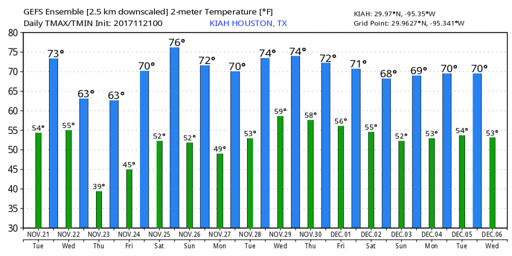
Expect breezy conditions when you wake up on Wednesday, as cooler and drier air will be blowing in from the north. We could see wind gusts in the upper teens to lower 20s of mph, and highs should only warm into the mid-60s under sunny skies.

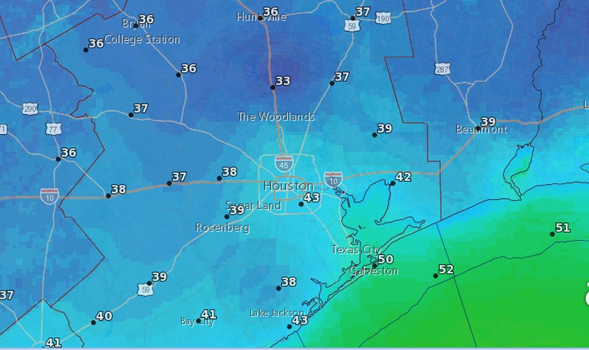
Wednesday night and Thanksgiving morning will be a cold one, with lows in the mid- to upper 30s for inland areas, and lower 50s right along the coast. After a clear and cold start to Thanksgiving, expect light winds, sunny skies, and a high of around 65 degrees during the afternoon.
Friday through Monday
The holiday weekend—and continuing into early next week—should see continued pleasant weather for the region. Daytime highs will climb into the upper 70s by Saturday, but a weak front should knock us back into the low- to mid-70s for Sunday and Monday with continued sunny skies. Overnight lows will hang around in the 50s. All in all, we should see some exceptional fall-like weather.
Over the next two weeks, none of the global models are suggesting too much in the way of precipitation. We’re also not seeing any signals for very strong cold fronts, or abnormally warm weather. All in all, it should be a nice start to December in Houston. It’s almost as if the weather will be too nice. Might it portend a winter ice storm later on? Or maybe we’re just getting some payback for Harvey’s misery.

Harvey wrap-up
Speaking of Harvey, Matt has started to write a weekly wrap-up of all the post-Hurricane Harvey news. There’s been a lot of it. We intend that this will become a weekly, informative feature as the region continues to recover from the storm and hardens its infrastructure for future flooding.

I have often wondered why the temperature in Conroe is usually lower than all the areas around it? Is the land topography there higher?
The airport location in Conroe is located in a “bowl” that generally sees low winds on cold nights, and this allows for more radiative cooling. Most areas around the official weather station in Conroe will be warmer than the temperature shown.
I have literally wondered about this for years. That makes sense. Thank you!
YES, YES, YES!!!!!!!!! THANK YOU PLANET EARTH!
Matt’s weekly wrap-up is a nice addition…appreciate the extra effort…thanks…hope you guys and family have a pleasant and safe Thanksgiving…
Same to you, Milt! Enjoy the cooler weather.
We deserve it!!! For the next 12 months!!!
(Would love to see a snow storm this winter. It’s always fun to watch people think the world is ending , claiming they couldn’t drive into work, and the seeing the mayor and county judge essentially shut down the whole county because we had 1/8″ of snow…or less…)
The problem here is we get a layer of ice under that 1/8″ of snow. In the northern tier the road surface temps are cold enough to allow the snow, for the most part, to act like dust. Here the snow melts before refreezing into black ice.
Watching the traffic reports in and around Chicago during the winter most folks up there can’t handle icy roads either…and they have a lot more practice then we do.
Apples and oranges…
Apples and oranges.
Our roads here tend to remain above freezing during snow events. The snow has time to melt before refreezing under that 1/8″ of snow. Black ice.
Looking at the carnage on the roads during ice events in the northern tier folks up there don’t fare any better then we do. And they have years more experience…
It seems to me that there may be a pattern of nearly drought conditions that seem to follow a hurricane. Wasn’t that the case with Rita and Ike as well, or am I just imagining things? It’s certainly been a bit unusually dry since Harvey.
Here ya go:
http://www.weather.gov/hgx/climate_iah_normals_summary
Except for a few outlier’s Sept. and Oct., along with Apr. tend to be our driest months.
Eric, have you seen the preliminary Atlas 14 data for Texas?
https://riparianhouston.com/2017/11/20/draft-provisional-atlas-14-data-out-for-peer-review/
The 1% annual chance, 24 hr event has increased more than I thought it would…
Michael Bloom
That is really interesting, Michael. Thank you for calling it to my attention.